Prologue: A Crack in the World’s Foundation
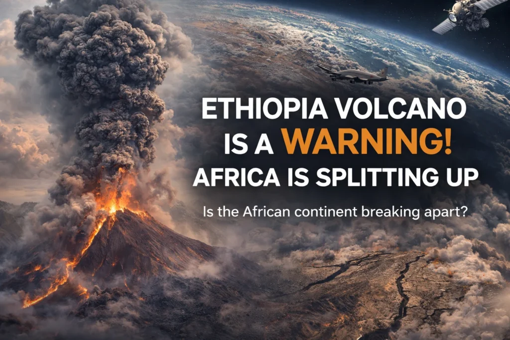
When the ground split open in Ethiopia’s Afar Depression on November 23, 2025, the event reverberated far beyond the immediate blast zone. For the nomadic Afar people who have inhabited this brutal landscape for centuries, the eruption of Hayli Gubbi volcano represented a cataclysm of biblical proportions—a mountain that had stood silent throughout all human memory suddenly speaking with the voice of primordial fire. For geologists watching from observatories across the globe, it represented something equally profound: the clearest signal yet that Africa’s slow-motion continental divorce has entered a new, more volatile phase.
This event, visible from space and felt across continents through disrupted flight patterns and altered atmospheric chemistry, serves as our entry point into one of geology’s most spectacular ongoing dramas. The story of the East African Rift is not merely about lava and fault lines—it is about the very mechanisms that build and destroy continents, the hidden forces that have shaped human evolution, and the inevitable future geography of our planet. What follows is a comprehensive exploration of how a single volcanic eruption connects to the grandest geological narrative on Earth.
Part I: The Awakening – Hayli Gubbi’s Return from 12,000 Years of Silence
Geological Context: A Sleeping Giant’s Biography
Hayli Gubbi stands as the southernmost sentinel in the Erta Ale volcanic range, a geological formation that serves as a surface thermometer for the Earth’s fiery interior. Unlike the steep-sloped stratovolcanoes that dominate popular imagination, Hayli Gubbi is a shield volcano—a gently sloping behemoth built over millennia by countless thin, fluid lava flows that spread great distances before cooling. This architectural style reveals its magmatic composition: basaltic magma, relatively low in silica, that flows easily rather than exploding violently.
The volcano’s pre-2025 dormancy placed it in a special category of geological features. As a Holocene dormant volcano, it had shown no activity throughout our current geological epoch—approximately the last 11,700 years. This period of silence encompassed the entirety of human civilization, from the dawn of agriculture in the Fertile Crescent to the development of satellite monitoring that would eventually capture its reawakening. The volcano’s quiescence was so complete that even local folklore, rich with tales of Erta Ale’s persistent lava lake to the north, contained no legends of Hayli Gubbi’s fiery potential.
The Precursors: Earth’s Whispered Warnings
The reawakening narrative began months before the actual eruption, with a series of subtle geophysical changes that created what scientists now recognize as a textbook case of volcanic precursors:
Seismic Stirrings (March-June 2025): The first signals emerged from Ethiopia’s sparse but strategically placed seismic network. Beginning in early spring 2025, instruments detected a gradual increase in low-frequency tremors—barely perceptible rumblings generated by magma moving through subterranean conduits. These harmonic tremors, distinct from the sharp jolts of tectonic earthquakes, represented the initial stirrings of molten rock at depths of 15-20 kilometers below the surface.
Ground Deformation (July-October 2025): As summer progressed, satellite-based interferometric synthetic aperture radar (InSAR) revealed the land itself was changing shape. Data from the European Space Agency’s Sentinel-1 satellites showed Hayli Gubbi’s flanks were inflating at a rate of approximately 3-4 centimeters per month—a dramatic swelling that indicated magma accumulating in a shallow reservoir just 2-5 kilometers beneath the surface. This inflation created a bullseye pattern on radar displacement maps that grew more pronounced with each satellite pass.
Geochemical Changes (August-November 2025): By late summer, the volcano began exhaling differently. Sensors detected increasing emissions of sulfur dioxide (SO₂) and carbon dioxide (CO₂)—magmatic gases escaping as fresh molten rock approached the surface. The ratio between these gases shifted tellingly, with SO₂ concentrations rising disproportionately, a signature often associated with impending explosive activity. Thermal infrared sensors aboard NASA’s Landsat and Terra satellites recorded steadily increasing ground temperatures around the summit, reaching 80°C above background levels by early November.
The Trigger: The Neighbor’s Influence
The immediate catalyst for Hayli Gubbi’s awakening came from its more famous neighbor, Erta Ale, located just 12 kilometers to the north. In mid-July 2025, Erta Ale—already one of Earth’s most active volcanoes with its permanent lava lake—entered a particularly vigorous eruptive phase. Beyond the surface spectacle, something crucial was happening underground: a substantial dike intrusion.
A dike is a vertical sheet of magma that forces its way through fractures in the crust. The July intrusion at Erta Ale traveled horizontally as well as vertically, propagating southward through subsurface pathways. Advanced satellite radar measurements revealed that this intruding magma body extended toward Hayli Gubbi, effectively creating a hydraulic connection between the two volcanic systems. The stress change induced by this intrusion likely “unclamped” the sealed magma chamber beneath Hayli Gubbi, much like releasing pressure on a shaken soda bottle.
The Eruption Chronology: Minute-by-Minute Cataclysm
The final act began in the predawn hours of November 23, 2025:
05:47 Local Time: A swarm of high-frequency volcanic earthquakes commenced, signaling the fracturing of rock as magma made its final ascent.
08:12 Local Time: Continuous harmonic tremor replaced discrete earthquakes—a sign that magma was now flowing freely through established pathways rather than forcing new ones.
11:30 Local Time: The initial explosion. The first breach was phreatomagmatic—groundwater flashing to steam upon contact with ascending magma. This violent steam explosion cleared the volcanic vent of debris, creating an opening approximately 300 meters across.
11:32 – 18:00 Local Time: Sustained Strombolian and Vulcanian activity. Incandescent lava bombs, some the size of small cars, were ejected to heights of 500 meters above the crater. A sustained eruption column developed, reaching its maximum altitude of 15 kilometers by early afternoon. The column’s vertical momentum was so powerful that it penetrated the tropopause—the boundary between the lower atmosphere and the stratosphere—injecting volcanic materials into altitudes where they could circulate globally.
Nightfall, November 23: The eruption entered its most visually spectacular phase. Pyroclastic fountains illuminated the ash cloud from within, creating a continuous lightning storm as ice particles and ash collided, generating static charges. Lava flows began issuing from fissures on the volcano’s southeastern flank, initially as narrow channels before broadening into expansive sheets that eventually covered approximately 8 square kilometers.
November 24-25: The explosive intensity gradually diminished, transitioning to effusive lava emission and persistent ash venting. By November 26, the eruption had effectively ended, though degassing and minor seismicity continued for weeks.
Immediate Local Impact: Life in the Shadow of the Eruption
For the Afar people, the eruption represented an environmental and humanitarian catastrophe of unprecedented scale in living memory:
Ashfall and Atmospheric Effects: Prevailing winds carried the bulk of the ash plume northeastward, but a significant portion settled locally. Communities within 50 kilometers of the volcano experienced total darkness at midday as the sun was blotted out. Accumulations reached 30 centimeters in the village of Afdera, 28 kilometers west of the volcano, collapsing roofs and rendering roads impassable.
Effects on Livelihoods: The pastoralist Afar economy faced devastation. Volcanic ash contaminated sparse grazing lands, posing multiple threats to livestock. The fine, abrasive particles caused severe dental abrasion in grazing animals, while ingestion led to gastrointestinal blockages known as phytobezoars—masses of undigestible material that can fatally obstruct digestive tracts. Water sources became contaminated with soluble fluoride leached from ash, causing acute poisoning in animals and humans alike.
Health Crisis: Respiratory ailments surged, particularly among children and the elderly. The fine ash particles, many smaller than 10 microns in diameter, penetrated deep into lungs, exacerbating existing conditions and causing new cases of acute silicosis. Eye infections from abrasive ash increased dramatically, compounded by limited access to clean water for washing.
Long-term Environmental Changes: The eruption permanently altered the local landscape. New cinder cones formed on the volcano’s flanks, while lava flows created impassable barriers across traditional migration routes. Perhaps most significantly, the eruption deposited mineral-rich volcanic materials that will alter soil chemistry for generations, potentially creating more fertile conditions in the long term but causing agricultural disruption in the immediate aftermath.
Part II: The Engine Beneath – Understanding the East African Rift System
Geological Framework: A Continent-Scale Divorce
The East African Rift System (EARS) represents one of the most significant and accessible examples of continental breakup on Earth. Stretching approximately 3,000 kilometers from the Afar Triple Junction in Ethiopia to Mozambique in the south, this colossal geological feature is essentially a wound in the Earth’s crust where the continent is tearing itself apart.
The fundamental mechanism is plate tectonics. The EARS marks a divergent boundary where two tectonic plates—the Nubian Plate to the west and the Somali Plate to the east—are moving away from each other at an average rate of 6-7 millimeters per year. While this pace seems negligible in human terms (roughly equivalent to the speed at which fingernails grow), over geological time it amounts to continental-scale deformation.
The Rift Architecture: Valleys, Volcanoes, and Lakes
The rift is not a single clean fracture but a complex system of interconnected geological features:
The Western Branch: Running along the borders of Uganda, Rwanda, Burundi, Tanzania, and Malawi, this branch is characterized by deep, freshwater lakes formed in fault-bounded basins. Lake Tanganyika, at nearly 1.5 kilometers deep, is the world’s second-largest freshwater lake by volume and represents a classic example of a rift valley lake.
The Eastern Branch: Passing through Ethiopia, Kenya, and Tanzania, this branch is more volcanically active, featuring numerous volcanoes like Ol Doinyo Lengai (the world’s only active carbonatite volcano), Mount Kenya (a dormant stratovolcano), and of course, the Erta Ale range containing Hayli Gubbi.
The Afar Triangle: Where the two branches converge in Ethiopia, they meet the Red Sea Rift, creating a triple junction—one of only a few such features on Earth. This region represents the most advanced stage of continental breakup, with the crust stretched so thin that it resembles oceanic rather than continental structure.
Crustal Dynamics: The Stretching and Thinning Process
The process of continental rifting follows a predictable sequence, though the timing at each stage varies considerably:
- Doming and Volcanism: Upwelling of hot mantle material causes the overlying crust to bulge upward, creating topographic highs. This stretching generates fractures through which magma can reach the surface, producing widespread volcanism.
- Rift Valley Formation: As stretching continues, the central portion of the dome collapses along bounding faults, creating a distinctive valley with steep walls—the classic rift valley topography.
- Crustal Thinning: Continued extension thins the continental crust from its normal thickness of 35-40 kilometers to less than 20 kilometers in the most advanced rifts like Afar.
- Oceanic Crust Formation: Eventually, the crust thins to the point where mantle material can rise, melt through decompression, and form new oceanic crust—the final stage of continental breakup.
The Afar region today exists between stages 3 and 4, with areas where the crust is essentially oceanic in character, while the southern portions of the rift remain in earlier stages of development.
The Mantle Plume Hypothesis: Africa’s Geological Heartbeat
Beneath the tectonic plates lies the ultimate driver of the rifting process: a mantle plume. This concept, first proposed in the 1970s and increasingly supported by sophisticated seismic imaging, suggests that a massive upwelling of exceptionally hot rock rises from deep within the Earth’s mantle—possibly from the core-mantle boundary nearly 3,000 kilometers down.
This “African Superplume” has several distinctive characteristics:
Thermal Anomaly: Seismic tomography reveals that the mantle beneath East Africa is 200-300°C hotter than surrounding mantle at equivalent depths. This thermal energy provides the buoyancy that lifts the crust and the heat that generates massive volumes of magma.
Chemical Signature: Volcanic rocks from the rift contain geochemical signatures indicating their source includes primordial material from the deep mantle, distinct from the shallower mantle sources that feed most mid-ocean ridges.
Dynamic Support: The plume’s upward force is responsible for elevating the East African Plateau, a region of anomalously high topography that includes much of Ethiopia, Kenya, and Tanzania. This plateau, averaging 1-2 kilometers above sea level, is essentially propped up by the buoyant mantle beneath.
The relationship between the mantle plume and surface volcanism is direct but complex. As the plume material rises, it experiences decreasing pressure, which causes partial melting. These melts then percolate upward, pooling at the base of the crust before finding pathways to the surface as volcanic eruptions. The Hayli Gubbi eruption represents one such release of this accumulated melt.
Comparative Rifting: East Africa in Global Context
The East African Rift is not unique in geological history, though it is exceptional in its current activity and accessibility. Other notable examples of continental rifting include:
The Atlantic Ocean: Approximately 200 million years ago, the supercontinent Pangaea began splitting apart, creating the Central Atlantic Magmatic Province (evident today in matching coastlines of Africa and South America) before eventually forming the Atlantic Ocean basin.
The Basin and Range Province, Western USA: This region represents a continental rift in its early stages, with widespread extension creating characteristic north-south trending mountain ranges separated by flat valleys.
The Rhine Graben, Central Europe: A well-studied but largely inactive rift system running through Germany, France, and the Netherlands.
What makes East Africa special is its combination of active extension, voluminous volcanism, and rapid evolutionary rates. It is essentially a real-time laboratory for observing processes that elsewhere occurred millions of years ago.
Part III: The Domino Effect – Volcanic Triggering and Interconnected Magmatic Systems
The Science of Volcanic Triggering
The concept that one volcanic event can influence another is well-established in volcanology but remains challenging to quantify. Several mechanisms can facilitate this triggering:
Static Stress Transfer: When magma moves within the crust (as with the dike intrusion at Erta Ale), it alters the stress field in surrounding rocks. This can effectively “unclamp” nearby faults or magma chambers, making them more likely to fail.
Dynamic Stress Transfer: Seismic waves from earthquakes or eruptions can pass through the crust, temporarily changing stresses as they propagate. While these changes are smaller than static stress changes, they can be sufficient to trigger activity in critically stressed systems.
Hydraulic Connections: In some volcanic fields, separate volcanoes may tap into interconnected magma reservoirs or share plumbing systems. A pressure change in one part of the system can therefore transmit to other parts.
Chemical Interactions: The injection of hot, fresh magma into a cooler, more evolved magma chamber can trigger mixing, which can dramatically increase volatility and pressure, potentially leading to eruption.
In the case of Hayli Gubbi and Erta Ale, evidence suggests a combination of static stress transfer from Erta Ale’s dike intrusion and possible hydraulic connections through deep crustal pathways.
Case Studies in Triggered Volcanism
The East African Rift has produced several historical examples of volcanic triggering:
2007-2011 Afar Rifting Episode: Between 2007 and 2011, a series of dike intrusions and eruptions occurred along a 60-kilometer segment of the rift in Afar. This episode began with an earthquake swarm, followed by a dike intrusion, which then triggered a series of smaller eruptions along its length over the following four years. The sequence provided volcanologists with unprecedented data on how rifting events propagate.
The 2018 Sierra Negra Eruption (Galápagos): While not in Africa, this eruption provided a clear example of triggering. Inflation measurements showed that the neighboring Fernandina volcano actually began deflating as Sierra Negra inflated and eventually erupted, suggesting magma transfer between the two systems.
The 2020 Taal Volcano Eruption (Philippines): This eruption was preceded by subtle inflation at the neighboring Laguna Caldera, suggesting possible magma movement between the two systems before the eruption.
These examples demonstrate that volcanoes, particularly those in close proximity within active tectonic zones, rarely behave as completely independent systems.
Monitoring Challenges in the Afar Region
Despite its geological significance, the Afar region presents extraordinary challenges for volcanic monitoring:
Sparse Instrumentation: The harsh environment, political instability, and remote location have limited the installation of permanent monitoring equipment. Until recently, the region relied on a handful of seismometers and occasional field campaigns for data collection.
Satellite Dependency: Consequently, satellite observations have become the primary monitoring tool. InSAR for ground deformation, MODIS and VIIRS for thermal anomalies, and Sentinel-5P for gas emissions provide crucial data streams, but these have limitations in temporal resolution and sensitivity to precursory signals.
Logistical Constraints: The region’s extreme heat (regularly exceeding 50°C/122°F), lack of infrastructure, and occasional security concerns make sustained field work difficult. Most monitoring is therefore conducted remotely from institutions in Europe, North America, and Ethiopia’s capital, Addis Ababa.
The Hayli Gubbi eruption highlighted both the value of existing satellite monitoring and the critical need for more ground-based instrumentation in this volatile region.
Part IV: Global Impacts – When a Local Eruption Disrupts a Connected World
The Atmospheric Journey of the Eruption Plume
The Hayli Gubbi eruption injected an estimated 220,000 tons of sulfur dioxide (SO₂) directly into the upper troposphere and lower stratosphere. The journey of this volcanic cloud demonstrates the interconnectedness of Earth’s atmospheric systems:
Days 1-2: Regional Transport
Initially, the plume drifted east-northeastward, carried by prevailing mid-level winds. Within 48 hours, it had traversed the full length of the Red Sea, affecting air quality in Yemen, Saudi Arabia, Oman, and reaching the Arabian Sea.
Days 3-5: Continental Scale Impact
By day three, the plume entered the subtropical jet stream—a high-altitude river of air flowing eastward at speeds exceeding 160 kilometers per hour. This carried the volcanic materials across the Arabian Sea to Pakistan and northwestern India. During this phase, the plume began to disperse both vertically and horizontally, creating a broader but less concentrated cloud of volcanic aerosols.
Days 6-10: Global Dispersion
The now-diluted but still chemically significant plume continued across northern India, affecting the densely populated regions of Punjab, Haryana, and Delhi, before moving over China and eventually dispersing across the northern Pacific. Satellite tracking showed detectable SO₂ concentrations circulating the entire Northern Hemisphere within two weeks of the eruption.
Aviation Disruption: The Modern World’s Vulnerability
The eruption’s most immediate global impact was on aviation, highlighting a critical vulnerability in our interconnected world:
The Physics of Ash-Aircraft Interaction:
Volcanic ash poses multiple hazards to aircraft:
- Engine Damage: At high turbine temperatures (exceeding 1,400°C), silicate ash particles melt and adhere to cooler turbine blades, disrupting airflow and potentially causing engine failure.
- Abrasion: Ash particles sandblast windshields, reducing visibility, and damage external sensors like pitot tubes.
- Electrical Systems: Ash can cause static discharge and short-circuiting in electrical systems.
- Air Quality: Fine ash penetrates cabin air systems, creating health hazards and potentially damaging air circulation equipment.
The Economic Toll:
Flight cancellations and reroutings had significant economic consequences:
- Direct Airline Losses: Major carriers reported combined losses exceeding $150 million from cancelled flights, extra fuel for rerouted flights, and aircraft inspections.
- Cascading Economic Effects: Disrupted travel affected tourism, business meetings, and cargo transport, with broader economic impacts estimated in the billions of dollars.
- Response Costs: Aviation authorities worldwide activated emergency protocols, with Volcanic Ash Advisory Centers (VAACs) working around the clock to model ash dispersion and advise airlines.
Regulatory Response:
The eruption prompted renewed discussion in international aviation forums about:
- Updates to ash concentration thresholds for flight operations
- Improved real-time ash detection technology
- Enhanced coordination between volcanologists and aviation authorities
Climate Implications: From Eruption to Potential Cooling
Large volcanic eruptions can influence global climate through the injection of sulfur dioxide into the stratosphere. When SO₂ reaches these heights, it oxidizes to form sulfate aerosols—tiny reflective particles that scatter incoming solar radiation back to space, potentially cooling the Earth’s surface.
For the Hayli Gubbi eruption, climate impacts were minimal but measurable:
Aerosol Loading: The eruption injected approximately 0.2 teragrams of SO₂ into the upper troposphere/lower stratosphere. While significant, this is approximately 1/50th of the 1991 Mount Pinatubo eruption that caused measurable global cooling.
Localized Climate Effects: Regional climate models suggested a slight cooling effect (0.1-0.2°C) over the Middle East and South Asia in the months following the eruption, though this was within normal seasonal variability.
Broader Implications: The event served as a reminder of how even moderately large eruptions can perturb the climate system, with potentially greater impacts if multiple volcanoes in the rift system were to erupt in closer succession—a possibility given the tectonic stresses affecting the region.
Part V: The Rift’s Deeper Story – Shaping Humanity’s Past and Future
Geological Foundations of Human Evolution
The East African Rift is often called the “Cradle of Humankind,” and this designation has profound geological underpinnings:
Topographic Diversity: The rifting process created a mosaic of environments within relatively small geographic areas—from mountain highlands to rift valleys, from freshwater lakes to volcanic highlands. This environmental patchwork provided diverse evolutionary pressures and opportunities for early hominins.
Fossil Preservation: The rift’s active geology created exceptional conditions for fossil preservation. Rapid sedimentation in rift basins buried bones quickly, while subsequent uplift and erosion exposed these fossil-rich layers for discovery millions of years later. The Awash Valley in Ethiopia, Olduvai Gorge in Tanzania, and Lake Turkana basins in Kenya—all within the rift system—have yielded the majority of early hominin fossils.
Climate Modulation: The uplift of the East African Plateau, driven by the mantle plume, altered regional climate patterns. The mountains created rain shadows, contributing to the replacement of forests with savannah grasslands—an environmental shift believed to have driven the adoption of bipedalism among our ancestors.
Resource Availability: Volcanic activity provided valuable resources for early humans, including obsidian for tools, mineral-rich soils for vegetation, and geothermal hotspots that may have served as early gathering places.
Archaeological and Paleoanthropological Treasures
The rift valley contains some of the most significant paleoanthropological sites in the world:
Hadar, Ethiopia: Site of the discovery of “Lucy” (Australopithecus afarensis), a 3.2-million-year-old hominin that walked upright but had a small brain.
Olduvai Gorge, Tanzania: Made famous by the Leakey family’s discoveries, including Homo habilis, one of the earliest members of our genus.
Lake Turkana, Kenya: Source of numerous important finds, including the 1.6-million-year-old “Turkana Boy” (Homo erectus), one of the most complete early human skeletons ever found.
Omo Valley, Ethiopia: Site of the earliest known Homo sapiens fossils, dating to approximately 200,000 years ago.
This concentration of evolutionary evidence is not coincidental—it is directly tied to the geological dynamics of the rift system.
The Future Rift: Africa’s Coming Geography
Projecting current geological processes millions of years into the future reveals a dramatically different African geography:
5-10 Million Years: The rift valley will have widened substantially, with the eastern branch potentially flooded by the Indian Ocean through a connection in the Afar region. A narrow seaway will separate the Horn of Africa from the mainland.
10-50 Million Years: The seaway will expand into a full ocean basin, with the Somali Plate carrying much of eastern Africa (including parts of Ethiopia, Somalia, and Kenya) drifting eastward. New mid-ocean ridges will form as seafloor spreading centers.
Beyond 50 Million Years: The new ocean basin will continue widening, eventually resembling the present-day Red Sea or Gulf of Aden in scale. The separated continental fragment—sometimes called “Greater Somalia” or “the Somalian Plate”—will develop its own distinct evolutionary trajectory, both geologically and biologically.
This process mirrors what happened when South America separated from Africa approximately 140 million years ago, eventually creating the South Atlantic Ocean. We are witnessing the early stages of a similar continental breakup in real time.
Implications for Biodiversity and Ecosystems
The continental separation will have profound biological consequences:
Vicariance Events: As the land splits, populations of plants and animals will be separated, leading to independent evolutionary trajectories on either side of the growing seaway—a process known as vicariance speciation.
Creation of New Coastlines: The formation of a new ocean will create thousands of kilometers of new coastline with associated marine ecosystems.
Climatic Effects: The changed geography will alter ocean currents and atmospheric circulation patterns, potentially affecting rainfall distribution across eastern Africa.
Endemism: Isolated fragments of the separating continent may become hotspots of endemic species, much like Madagascar today—itself a continental fragment that separated from Africa approximately 160 million years ago.
Part VI: Living with the Rift – Human Adaptation to a Changing Landscape
Indigenous Knowledge and Adaptation Strategies
The Afar people and other communities inhabiting the rift valley have developed sophisticated adaptation strategies to their volatile environment:
Seismic and Volcanic Lore: Traditional knowledge systems include methods for interpreting minor earthquakes as precursors to larger events, stories that preserve memory of past eruptions, and taboos that prevent settlement in particularly hazardous areas.
Pastoralist Mobility: The nomadic lifestyle of many rift communities represents an adaptation to environmental unpredictability. Mobility allows rapid evacuation from threatened areas and exploitation of scattered resources.
Water Management: In an arid region with limited surface water, communities have developed intricate knowledge of groundwater sources, including how to find water in apparently dry riverbeds and how geothermal features can indicate subsurface water.
Architectural Adaptations: Traditional building techniques use flexible materials that withstand minor tremors, and settlements are often located on stable geological formations rather than in active fault zones.
Modern Challenges and Resilience Building
Contemporary populations face new challenges in the rift region:
Urbanization: Growing cities like Nairobi, Kampala, and Addis Ababa increasingly encroach on geologically hazardous areas, with building codes often inadequately enforced for seismic safety.
Resource Exploitation: The rift contains valuable resources—geothermal energy, minerals, fertile soils—whose exploitation must be balanced against geological hazards and environmental protection.
Climate Change Interactions: Changing precipitation patterns may interact with volcanic and seismic hazards in complex ways, potentially increasing landslide risks or affecting groundwater interactions with magma systems.
Early Warning Systems: Efforts are underway to improve monitoring and early warning, but these face challenges of funding, maintenance, and integration with traditional knowledge systems.
The Role of International Science and Collaboration
The East African Rift serves as a natural laboratory attracting scientists from around the world:
Multidisciplinary Research: Geologists, geophysicists, geochemists, climatologists, and biologists collaborate to understand the rift system comprehensively.
Technology Development: The challenging environment drives innovation in remote sensing, ruggedized instrumentation, and data transmission from isolated locations.
Capacity Building: International partnerships increasingly focus on training African scientists and technicians to build local expertise in geohazard assessment and mitigation.
Knowledge Integration: Projects are working to integrate scientific monitoring with indigenous knowledge systems, recognizing that both have value in understanding and responding to geological hazards.
Part VII: Beyond Africa – Lessons for Understanding Planetary Evolution
Comparative Planetology: Rifts on Other Worlds
The study of Earth’s rift systems informs our understanding of other planetary bodies:
Venus: The planet shows evidence of extensive rift systems, though their formation mechanisms may differ due to Venus’s lack of plate tectonics and extreme surface temperatures.
Mars: Valles Marineris, the largest canyon in the solar system, represents a rift-like feature, though its formation likely involved different processes than terrestrial rifts.
Europa and Enceladus: These icy moons of Jupiter and Saturn respectively show evidence of rift-like features in their ice shells, potentially created by tidal forces rather than internal heat.
Exoplanet Implications: Understanding terrestrial rifting helps model the geological evolution of rocky exoplanets, with implications for their habitability.
The Rift in Earth System Science
The East African Rift exemplifies the interconnectedness of Earth systems:
Solid Earth-Atmosphere Interactions: Volcanic emissions affect atmospheric chemistry and climate, while climate patterns (like rainfall) can influence volcanic activity through groundwater interactions.
Geosphere-Biosphere Coevolution: The rift’s geological evolution has directly shaped biological evolution, while biological processes (like the rise of oxygen-producing photosynthesis billions of years ago) have influenced geological processes.
Human-Geosphere Interactions: Human activities, from groundwater extraction to reservoir construction, can potentially influence geological hazards by changing subsurface stress distributions.
Temporal Scaling: The rift operates on timescales from seconds (earthquakes) to millions of years (continental separation), challenging integrated observation and understanding.
Philosophical and Cultural Perspectives
The spectacle of a continent tearing itself apart has inspired philosophical and cultural reflections:
Deep Time Awareness: The rift makes tangible the concept of geological time—the realization that landscapes we perceive as permanent are in constant, if slow, transformation.
Human Scale vs. Geological Scale: Our brief human lifespans contrast dramatically with geological processes, raising questions about how societies can make decisions that account for processes operating on million-year timescales.
Mythology and Geology: Many creation myths from rift valley cultures feature themes of splitting, separation, and emergence from below—perhaps preserving cultural memory of geological events.
Artistic Inspiration: The dramatic landscapes of the rift have inspired countless artists, writers, and filmmakers, often serving as metaphors for division, creation, or transformation.
Epilogue: Listening to the Continent’s Heartbeat
The eruption of Hayli Gubbi in November 2025 was more than a spectacular natural event. It was a punctuation mark in a geological story that began tens of millions of years ago and will continue for tens of millions more. It reminded us that the ground beneath our feet—seemingly the epitome of stability—is in fact dynamic, mobile, and ever-changing.
This event highlighted both our vulnerability and our growing understanding. We are vulnerable because a geological event in one of Earth’s most remote regions can disrupt global transportation networks within days. Yet we are increasingly understanding because we can now connect that event to mantle plumes thousands of kilometers deep, to continental-scale tectonic processes, and to the very forces that shaped human evolution.
The East African Rift offers us a unique window into our planet’s inner workings. As we improve our monitoring, refine our models, and deepen our collaboration with the communities that call this dynamic landscape home, we move closer to a comprehensive understanding of this magnificent geological drama.
The final lesson of Hayli Gubbi’s awakening may be this: We are living on a planet that is still being born, still reshaping itself, still writing its geological story. The continents we see on today’s maps are temporary arrangements in Earth’s long history. Africa’s splitting is not an anomaly but a fundamental planetary process—one that has created new oceans in the past and will create new oceans in the future. Our challenge and opportunity is to understand this process, adapt to its hazards, and appreciate the profound geological forces that continue to shape our world.
As the Afar people return to their grazing lands, as airlines adjust their flight paths, and as scientists refine their models of magma ascent and plate divergence, the rift continues its slow, inexorable work. The continent keeps splitting, millimeter by millimeter, eruption by eruption, earthquake by earthquake. And we, fortunate to live in this particular geological moment, get to witness the extraordinary process of a world remaking itself.