
Prologue: The Quiet Crisis and the Digital Dawn
The Earth is losing its animal inhabitants at a rate that scientists are calling the sixth mass extinction. Unlike the dinosaurs’ demise, which was caused by a catastrophic asteroid impact, this one has a single cause: us. Habitat destruction, poaching, climate change, pollution, and the relentless expansion of human activity are pushing thousands of species toward the abyss. The International Union for Conservation of Nature estimates that more than 42,100 species are threatened with extinction. That’s 28 percent of all species assessed. The numbers are staggering, but behind each statistic is a story—a population of orangutans clinging to the last fragments of Bornean forest, a pod of vaquita porpoises drowning in fishing nets in the Gulf of California, a rhino mother and calf cut down for their horns in the African bush.
For decades, the guardians of the wild—the park rangers, biologists, and conservationists—fought back with limited tools: boots on the ground, paper maps, binoculars, and handwritten logs. They walked hundreds of miles through dense jungles, slept in leaky tents, and risked their lives confronting armed poachers. It was a noble fight, driven by passion and commitment, but it was often like trying to stop a flood with a garden hose. The forces arrayed against them were simply too powerful, too well-funded, too determined.
Then something began to shift. The same technological revolution that put smartphones in our pockets, connected the world through the internet, and sent robots to Mars began to trickle into the rainforests, savannas, and oceans. Conservationists realized that the tools of the modern world could become the shields of the ancient one. Drones developed for military surveillance could watch for poachers. Artificial intelligence designed for facial recognition could identify individual animals by their unique markings. Genetic sequencing techniques used in hospitals could detect the presence of rare species in a single cup of water. Video game technology could engage millions of people in real conservation work.
This is the story of that transformation—a global, ground-level, deeply human look at how drones, artificial intelligence, genetic sequencing, satellite imagery, acoustic monitoring, and even video games are changing what it means to save a species. It’s a story that spans seven continents and countless cultures, from the icy waters of the Antarctic to the steamy jungles of Sumatra, from the high-tech laboratories of Silicon Valley to the community conservation camps of the Maasai. It’s a story of hope, innovation, and the unshakeable belief that it’s not too late to make a difference.
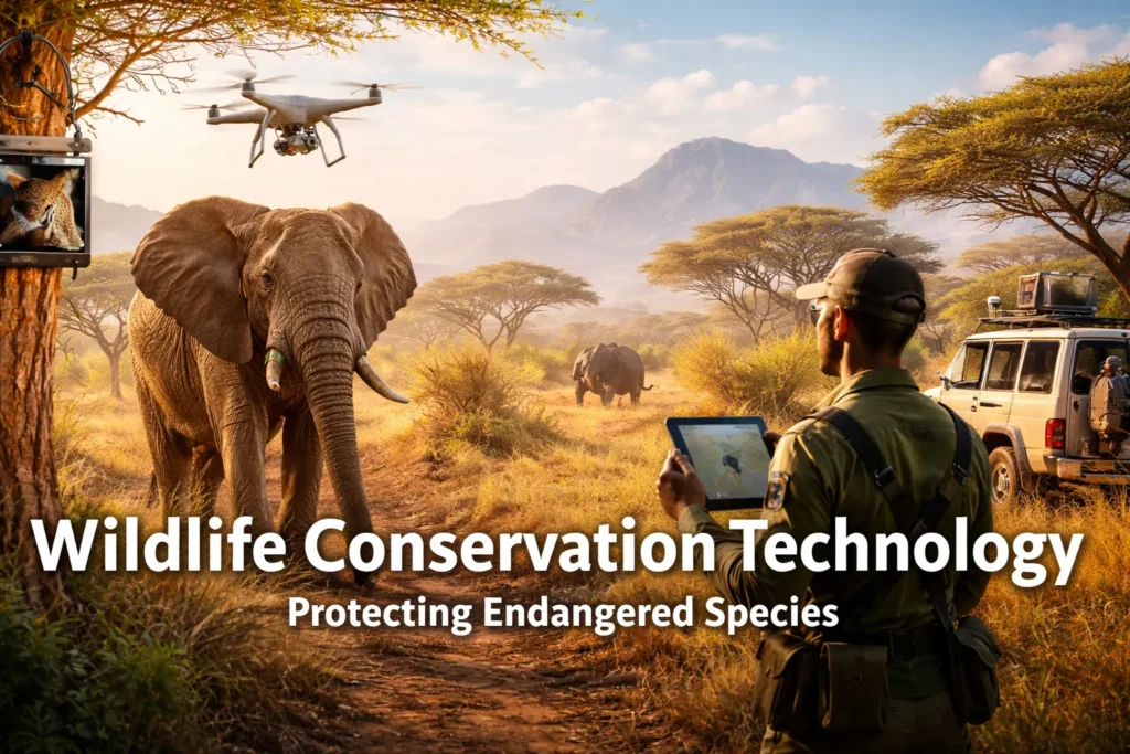
In the quiet before dawn at Kenya’s Ol Pejeta Conservancy, a different kind of bird takes flight. It isn’t made of feathers, but of carbon fiber and silicon. It doesn’t sing, but it listens. It doesn’t eat, but it watches. As it glides over the savanna, its thermal eye cuts through the darkness, picking up the heat signatures of rhinos moving through the tall grass—and, more importantly, the cooler shapes of humans who shouldn’t be there. This drone doesn’t get tired, it doesn’t get distracted, it doesn’t get scared, and it doesn’t forget what it sees. It is the new face of conservation, and it represents a beacon of hope in what often feels like a losing battle.
Meanwhile, on the other side of the world in Madagascar, a team of local conservationists huddles around a laptop that is covered in dust and sticky from humidity. The screen glows in the predawn darkness of their field camp, illuminating faces etched with exhaustion and excitement. On the screen, drone footage reveals something incredible: thermal images of the Critically Endangered Alaotran gentle lemur, a species so shy and rare that getting an accurate count has always been nearly impossible. For years, they relied on estimates and guesswork, on indirect signs and local reports. Now, they have data—hard, undeniable proof of where these tiny primates live, how many might be left, and how they use their threatened wetland habitat. The excitement in the tent is palpable, a reminder that in conservation, knowledge is not just power; it is survival.
And in a modest locker in Utrecht, Netherlands, millions of people are watching fish. Not on a nature documentary, not in an aquarium, but on a live stream from an underwater camera. With a click of a virtual doorbell, they are helping bream, pike, and perch swim through city locks to reach their spawning grounds upstream. What started as a simple idea from a local ecologist has become a global phenomenon, connecting people in Tokyo, New York, Sydney, and Cape Town to the migration patterns of fish in a Dutch river. It is a powerful reminder that conservation is no longer just for scientists and rangers working in remote locations—it is for everyone, everywhere, and it can start with something as simple as clicking a button.
This isn’t science fiction. This is the new face of wildlife conservation. For decades, protecting endangered species meant binoculars, notebooks, and a lot of patience. But as our planet faces an unprecedented biodiversity crisis, conservationists are trading in their field glasses for joysticks, coding languages, and data dashboards. They are discovering that sometimes, to save the natural world, you need a little help from the high-tech one. This article will take you on a journey across continents and through cutting-edge laboratories to explore how technology is revolutionizing the fight to preserve life on Earth. We’ll meet the people behind the machines, hear the stories of the animals being saved, and grapple with the ethical questions that arise when we use technology to watch over the wild.
Part One: The All-Seeing Sky
Chapter 1: Drones and the Art of Invisible Observation
Imagine trying to count every single person in a bustling city like New York or Tokyo, but you can’t use cameras, you can’t ask questions, you have to do it without anyone noticing you’re there, and the people you’re counting are actively trying to avoid you. They hide in basements and attics, they move only at night, and they have excellent reasons to be wary of humans. That’s the challenge conservationists have always faced when monitoring wildlife. Animals don’t stand still for census takers. They hide in dense vegetation, they move under cover of darkness, and they have evolved over millions of years to avoid predators—including the human kind.
Enter the drone. These unmanned aerial vehicles (UAVs) are like a Swiss Army knife for conservation. They are fast, they are quiet, and they can go where humans can’t—or shouldn’t. A drone can fly over a swamp that would take a human team days to traverse on foot, and it can do it without sinking into the mud or contracting waterborne diseases. It can hover at a height that doesn’t disturb nesting birds while still getting crystal-clear images. It can fly at night, seeing in thermal wavelengths that are invisible to the human eye. It can follow animal movements for hours without getting tired. And perhaps most importantly, it doesn’t get scared, it doesn’t need to stop for lunch, and it doesn’t require hazardous duty pay.
The technology has evolved rapidly and dramatically. Early conservation drones were essentially hobbyist models with consumer cameras strapped to them—think of the quadcopters you might see in a park on a weekend. They were fragile, had limited battery life, and could only carry lightweight cameras. Today, organizations like the World Wildlife Fund, the Nature Conservancy, the Wildlife Conservation Society, and countless smaller grassroots groups are using military-grade thermal imaging cameras that can detect the heat signature of a mouse from 200 feet up. They use multi-spectral sensors that can see through camouflage and detect plant health, identifying areas of forest degradation before they’re visible to the human eye. They deploy fixed-wing drones that can stay aloft for hours, covering hundreds of square kilometers in a single flight, mapping entire ecosystems with centimeter-level accuracy.
The cost has come down dramatically as well. What once required a budget of hundreds of thousands of dollars and a team of aerospace engineers can now be accomplished with equipment costing a few thousand dollars and a few days of training. This democratization of technology is perhaps its most important feature, making it accessible to cash-strapped conservation groups in developing nations who are often on the front lines of the battle to save biodiversity.
In the dense wetlands of Madagascar, the Durrell Wildlife Conservation Trust is using drones mounted with thermal sensors to do more than just spot lemurs. They are writing a new chapter for the species. The Alaotran gentle lemur, known locally as the bandro, lives only in the marshes around Lake Alaotra, the largest lake in Madagascar. These lemurs have been pushed to the brink by habitat destruction—the marshes are being converted to rice paddies—and by hunting. They are small, shy, and live in papyrus reeds that can grow taller than a person. Finding them has always been a nightmare of guesswork and frustration. Researchers would spend weeks wading through waist-deep water, getting leeched and mosquito-bitten, and might only catch glimpses of the animals as they fled.
By flying over the marsh at night, the drones see a completely different world. The thermal cameras don’t just show that a lemur is there; they reveal the heat of the lemurs’ bodies against the cool night air, making them glow like beacons in the darkness. The cameras can distinguish between individuals by their size and movement patterns. In a single season of drone surveys, the Durrell team gathered more data on lemur distribution than in the previous decade of ground surveys. They produced the first accurate, range-wide population estimate ever possible, revealing that there are far fewer lemurs than anyone had feared. This data is gold. It tells conservationists exactly where to focus their restoration efforts, which areas need the most protection, and whether their work is actually helping the population grow. For the first time, they aren’t guessing—they know.
The Madagascar project is just one example among hundreds. Across Africa, drones are being used to count elephant herds in countries like Malawi, Zimbabwe, and Botswana, where aerial surveys used to require dangerous, low-flying manned aircraft that cost thousands of dollars per hour and put pilots and observers at risk of crashing into trees or being shot at by poachers. Now, drone teams can launch from a village clearing, fly pre-programmed transects over the bush, and land back at base with high-resolution imagery that allows researchers to identify individual elephants by their ear patterns and tusk shapes. The data is more accurate, safer to collect, and a fraction of the cost.
Chapter 2: The Australian Sea Lion Mystery
It’s not just about counting heads. Sometimes, technology helps us ask better questions and get deeper answers. In Australia, scientists are facing a heartbreaking puzzle that has defied solution for decades. The Australian sea lion population has crashed by more than 60 percent in just forty years. These are not animals that live on easy-to-reach beaches with convenient parking lots and visitor centers. Their homes are on remote, rocky islands off the southern coast, battered by the fierce storms of the Southern Ocean and surrounded by waters that are too rough for small boats much of the year. They are incredibly hard to study, and their decline has happened largely out of sight and out of mind.
Researchers from the South Australian Research and Development Institute, working in partnership with the Department for Environment and Water, are now using a combination of helicopters and drones to survey these inaccessible coastlines. But they aren’t just flying over and taking pretty pictures. They are experimenting with photogrammetry—a sophisticated technique that creates detailed three-dimensional models from hundreds of overlapping photographs. Think of it as creating a digital twin of the island and every animal on it, a virtual world that scientists can explore and measure without ever leaving their offices.
Using photogrammetry, scientists can measure the body condition of individual sea lions without ever getting close to them. They can tell if a pup is growing at a healthy rate by comparing its size to the rocks around it. They can detect if an adult is malnourished by the visible outlines of its ribs and hips. They can assess whether a colony has enough food resources by tracking changes in average body condition over time. All of this information was previously impossible to gather without capturing and handling the animals, which is stressful, dangerous, and logistically challenging.
They are also using LiDAR, which stands for Light Detection and Ranging. LiDAR uses lasers shot from the aircraft to measure distance with incredible precision—think of it as radar but with light instead of radio waves. The laser pulses bounce off the ground and return to the sensor, and by measuring the time it takes for each pulse to return, the system builds a map of the terrain so detailed that it shows every rock, every crevice, every slope, every clump of vegetation. From this data, researchers can create elevation models accurate to within a few centimeters.
By combining photogrammetry and LiDAR, researchers aren’t just finding sea lions; they are building a complete picture of their habitat. They can see how sea level rise might affect pupping beaches over the coming decades, identifying which colonies are most vulnerable to climate change. They can analyze how storm patterns change the availability of resting areas and how that affects sea lion behavior. They can track how vegetation changes—perhaps due to introduced pests or changing rainfall—might impact the microclimate of the colony. This is the difference between treating a symptom and understanding the disease. The goal is to answer the fundamental question: why are these sea lions disappearing, and what can we do to stop it?
The project is also notable for its deep partnership with Indigenous communities. The Esperance Tjaltjraak Native Title Aboriginal Corporation is not merely consulted but is a genuine co-leader of the research. Traditional Owners are being trained to fly drones, analyze data, and conduct surveys, bringing their own knowledge of Sea Country—knowledge passed down through generations about animal behavior, weather patterns, and the health of the ecosystem. They know where the sea lions used to haul out decades ago, how their behavior changes with the seasons, and what the old people said about caring for these animals. This two-way exchange makes the science better, the conservation stronger, and ensures that the work is rooted in the place it seeks to protect.
Chapter 3: Silent Sentinels Over India
In India, drones known as “Garuda”—named after a mythical bird deity from Hindu mythology who is the king of birds and the mount of Lord Vishnu—are becoming a powerful weapon in the fight against poachers in famous parks like Kaziranga National Park, Corbett Tiger Reserve, and Manas National Park. Kaziranga, a UNESCO World Heritage site in the state of Assam, is home to the world’s largest population of one-horned rhinos, and it has been a battleground for decades. Poachers kill rhinos for their horns, which are falsely believed to have medicinal properties in some Asian cultures and are also prized as status symbols. The park’s rhino population has rebounded from near-extinction at the beginning of the 20th century to more than 2,400 today, thanks to aggressive protection, but the poachers haven’t given up.
Equipped with night-vision and heat-sensing cameras, these silent sentinels patrol the park at night when poachers are most active. They can spot a poacher’s cooking fire from miles away, detecting the infrared signature of flame and warm ash. They can detect the heat signature of a human body moving through the tall elephant grass, even if that person is trying to hide. They can track a patrol team’s movement through the dense jungle, ensuring that rangers are safe and that reinforcements can be dispatched if needed. The drone feeds video in real-time to a command center, where operators can direct ground teams to intercept intruders with precision.
The advantage is fundamentally tactical. In the past, poachers operated under cover of darkness, knowing that rangers were limited to flashlight beams and listening for sounds. The night was their ally. Now, the night belongs to the rangers. The drone doesn’t get tired, it doesn’t get scared, it doesn’t blink, and it gives the protection team the one thing they need most in a firefight: information. They know where the poachers are, how many there are, what weapons they might be carrying, and which direction they’re moving, all before ever getting within rifle range.
The technology has also proven to be a powerful deterrent. Word spreads quickly in the communities around the parks, through networks of families, friends, and informants. When poachers know that the sky is watching, that there’s no place to hide, they think twice before entering. The number of successful poaching incidents has dropped dramatically in areas where drone patrols are active, and the number of poachers arrested has increased. It’s a powerful example of how technology can shift the balance of power decisively in favor of the protectors.
But the drones do more than catch bad guys. They also help with habitat management in ways that were previously impossible. The high-resolution imagery allows park managers to monitor grassland health, tracking changes in vegetation density and species composition over time. They can detect the spread of invasive plant species that threaten native habitats, often spotting infestations years before they would be noticed from the ground. They can map water sources during the dry season, identifying which pools are drying up and which still hold water, helping managers decide where to focus anti-poaching efforts and where to guide tourists. They can see how animals are using different parts of the park—where they concentrate, where they avoid, where they cross roads—and adjust management strategies accordingly. The drone that watches for poachers by night becomes a tool for ecological understanding by day.
Chapter 4: The Forest Canopy from Above
In the Amazon rainforest, the largest and most biodiverse tropical forest on Earth, drones are solving a problem that has vexed scientists for generations: how to study the canopy. The roof of the jungle, hundreds of feet above the ground, is where most of the biodiversity lives. It’s home to countless species of monkeys, sloths, birds, insects, and epiphytic plants that never touch the forest floor. The canopy is the engine of the rainforest, where photosynthesis happens, where flowers bloom and fruit ripens, where the majority of animal interactions occur.
But it’s also incredibly difficult to reach. Climbing trees is dangerous, slow, and requires specialized equipment and training. A single climb can take hours and disturbs the very animals you’re trying to study. Building towers is expensive, limited to a single location, and still doesn’t give you access to the broader landscape. Using manned aircraft is noisy, disruptive to wildlife, prohibitively expensive for most research projects, and often impossible in remote areas without landing strips.
Drones are changing that completely. Researchers are now using small drones that can launch from a forest clearing, fly up through a gap in the trees, and then navigate above the canopy, collecting high-definition video and photos of the treetops without ever disturbing the animals below. They can spot howler monkeys moving through the branches, counting individuals and documenting their behavior. They can find the massive stick nests of harpy eagles, some of the rarest and most powerful raptors in the world, and monitor breeding success. They can identify flowering trees that are critical food sources for pollinators, mapping resources that were previously invisible.
In Peru, the Amazon Conservation Association is using drones to map forest carbon stocks with unprecedented accuracy. By creating three-dimensional models of the forest from drone imagery, they can calculate how much carbon is stored in the trees with far greater precision than satellite estimates allow. This is crucial for carbon offset programs, which rely on accurate measurements to ensure that carbon credits represent real, additional, and permanent reductions in atmospheric carbon. It’s also essential for understanding the role of the Amazon in regulating the global climate, providing the data needed to model future climate scenarios.
The drones are also used to detect illegal gold mining operations, which are tearing up large areas of forest and poisoning rivers with mercury. From the air, the bright blue pools of mining ponds are unmistakable against the green forest. The dredges, the camps, the denuded landscapes are all visible. Rangers can be dispatched to shut down operations before more damage is done, and the imagery provides evidence for prosecutions. In some cases, the mere presence of drones has deterred miners from entering an area, knowing they can be seen and documented.
In Borneo, drones are helping to protect the last remaining habitat of the critically endangered Bornean orangutan. As oil palm plantations expand, the forest becomes fragmented into isolated patches, creating islands of habitat surrounded by a sea of agriculture. Orangutans, which need large areas of continuous forest to find enough food, become trapped in these fragments, unable to move between them. Drones map these fragments, showing which are still connected by wildlife corridors and which are becoming islands. Conservationists can then work with local communities and plantation companies to restore corridors, planting native trees to reconnect habitats and allow orangutans and other animals to move safely between fragments. It’s a landscape-level view that was impossible to get from the ground, and it’s essential for making good decisions about where to invest limited restoration resources.
Chapter 5: Drones Over the Ocean
The ocean is the next frontier for drone conservation. While we often think of drones as tools for terrestrial environments, they are equally valuable over water. Marine conservation faces unique challenges—the sheer size of the ocean, the difficulty of accessing remote areas, the mobility of marine animals, and the opacity of water that hides what lies beneath. Drones are helping to overcome these challenges in remarkable ways.
In the waters off British Columbia, researchers are using drones to study killer whales, one of the most iconic and endangered marine mammals in the world. The Southern Resident killer whale population, which frequents the waters between Washington State and British Columbia, has declined to just 73 individuals. Understanding their health is critical for conservation, but getting close enough to assess body condition has always been difficult. Boats disturb the whales and are subject to strict approach regulations. Researchers have now developed drone-based photogrammetry techniques that allow them to measure the whales from above without ever getting close. They can assess whether a whale is pregnant, whether a juvenile is growing properly, and whether the population is getting enough to eat.
In Australia, drones are being used to study humpback whales during their annual migration along the east coast. The drones capture aerial footage that reveals the whales’ body condition, their behavior, and even the presence of new calves. This data is helping researchers understand how climate change is affecting whale populations by altering the availability of their prey in feeding grounds.
In the Maldives, drones are being used to study manta rays, the graceful giants of the reef. The drones can follow mantas as they feed in shallow waters, revealing how they use different habitats and how they respond to tourist pressure. This information is being used to design better marine protected areas and to regulate the growing manta ray tourism industry.
In the fight against illegal fishing, drones are becoming essential tools. Illegal, unreported, and unregulated fishing is one of the biggest threats to ocean health, costing billions of dollars and devastating fish populations. Drones can patrol large areas of ocean, spotting fishing vessels that are operating in protected areas or using illegal gear. In the Galapagos Marine Reserve, one of the largest and most biodiverse marine protected areas in the world, drones are used to monitor for illegal fishing vessels. When a vessel is spotted, the drone can capture video evidence and alert patrol boats, which can then intercept the vessel. The drones extend the eyes of the patrol force, covering far more area than boats alone could monitor.
Chapter 6: The Ethics of Aerial Surveillance
As drones become more common in conservation, they raise important ethical questions that the conservation community is only beginning to grapple with. The same technology that can watch for poachers can also watch local communities. The drone that flies over a national park also flies over villages on the park boundary. The camera that captures a rhino also captures a farmer tending his fields, children playing, women collecting water.
This raises concerns about surveillance, privacy, and consent. Conservation organizations are guests in these landscapes, and they have a responsibility to respect the rights and dignity of local people. Some communities have pushed back against drone surveillance, expressing concerns that they are being watched without their permission. Others have welcomed the technology, seeing it as a tool that can help protect their lands and resources.
There are no easy answers to these questions, but there are emerging best practices. Many organizations now consult with local communities before beginning drone operations, explaining what they’re doing, showing examples of the imagery, and addressing concerns. Some have developed protocols for blurring or deleting images that include people, only retaining data relevant to wildlife. Others have trained local community members to operate the drones, giving them control over the technology and ensuring that surveillance is done by and for the community, not by outsiders.
The ethical questions don’t stop with privacy. There are also questions about the impact of drones on wildlife. While drones are generally less disturbing than manned aircraft or ground approaches, they can still stress animals. Some species are more sensitive than others. Birds of prey have been known to attack drones, sometimes damaging them and potentially injuring themselves. Marine mammals may be disturbed by the presence of drones overhead. Researchers are studying these impacts and developing guidelines for drone use that minimize disturbance, such as maintaining minimum altitudes, avoiding sensitive areas during breeding seasons, and limiting flight times.
There are also questions about equity and access. Drones are becoming cheaper, but they’re still expensive. Organizations in wealthy countries have access to the latest technology, while those in developing countries often make do with older equipment or go without. This creates a technological divide that mirrors economic divides. Some organizations are working to address this by providing equipment and training to partners in developing countries, by developing open-source drone designs that can be built locally, and by advocating for technology transfer as part of conservation funding.
Part Two: The Digital Ranger
Chapter 7: Artificial Intelligence on Patrol
Gathering all that footage from drones and camera traps creates a massive problem: what do you do with millions of photos and hundreds of thousands of hours of video? A typical camera trap study in a moderately sized national park might generate tens of thousands of images in a single month. A multi-year study across multiple sites can generate millions. Hiring a team of interns to scroll through them all would take years and cost a fortune. And humans get tired, they get bored, they get distracted, and they make mistakes. They miss things. They misidentify species. They fall asleep at their screens.
This is where a new “digital ranger” comes to the rescue: Artificial Intelligence (AI). AI is like a super-powered intern who never sleeps, never gets bored, never gets distracted, and never misses a detail. It can scan through millions of images in hours, identifying animals, counting them, and even recognizing individuals. Machine learning algorithms can be trained to distinguish between different species, to ignore wind-blown grass that might trigger a motion sensor, and to flag images that show something unusual or unexpected.
The training process is fascinating. To teach an AI to recognize a jaguar, you show it thousands of images of jaguars. It learns the patterns—the shape of the body, the arrangement of spots, the way the animal moves. You also show it thousands of images of things that aren’t jaguars—other animals, vegetation, empty frames. It learns to distinguish between them. The more images you show it, the better it gets. Modern AI systems can achieve accuracy rates that rival or exceed human experts, and they can do it at speeds that humans can’t match.
In Scotland, conservationists were trying to protect the elusive flapper skate, a type of fish that looks like something from the dinosaur age. These massive rays—they can grow to six feet across and weigh over 200 pounds—are critically endangered in European waters. They live on the seabed in relatively deep water and are incredibly difficult to study. Divers rarely see them because they’re too deep and the water is too murky. Trawl surveys damage their habitat and are banned in many areas. But they do swim through certain areas, and researchers set up AI-powered camera traps on the seabed to watch for them.
The results were astonishing and came faster than anyone expected. The AI could instantly identify the skates as they glided past the cameras, distinguishing them from other fish like cod and haddock, from crabs and lobsters moving along the bottom, and from debris moving in the current. In protected areas where fishing is banned, the detection rate of these rare fish jumped by 92 percent compared to areas where fishing was allowed. This was powerful, undeniable evidence that marine protected areas work—that giving fish a place to recover actually allows them to recover. It gave conservationists the data they needed to advocate for expanding those protections and for creating new protected areas in other regions. Without AI, the sheer volume of footage would have made the study impossible. With AI, they got clear, compelling, statistically significant proof.
Chapter 8: Listening to Jaguars
In the lush jungles of Mexico’s Dzilam de Bravo State Reserve, on the Yucatan Peninsula, the Tech4Nature project has given a voice to the jaguar. This ambitious partnership between technology companies, conservation organizations, and the Mexican government has created one of the most sophisticated wildlife monitoring systems in the world. They installed over 20 camera traps and 60 audio monitors across thousands of hectares of protected forest, creating a network of digital ears and eyes that never sleeps.
The cameras are smart—far smarter than traditional camera traps. Using advanced pattern recognition algorithms, they can identify individual jaguars by their unique spot patterns. Just like a human fingerprint, no two jaguars have the same arrangement of rosettes. When a jaguar walks past a camera, the AI compares its pattern to a database of known individuals, recognizing who it is in real-time and logging the sighting. This tells researchers which jaguars are using which parts of the reserve, how far they travel, what time of day they’re active, and whether they are staying in protected areas or venturing onto nearby farmland where they might come into conflict with people.
The audio monitors are even more remarkable. They record the sounds of the forest 24 hours a day, seven days a week, 365 days a year. They capture the predawn chorus of birds, the midday drone of insects, the evening calls of frogs, the nighttime rustlings of mammals. The AI listens to this constant stream of data, filtering through millions of sounds to find the ones that matter. It ignores the wind in the trees, the rain on the leaves, the distant rumble of thunder. It’s trained to pick out the deep, guttural growl of a jaguar, the rasping call that carries through the jungle for miles. Every time a jaguar calls—to mark territory, to find a mate, to communicate with its cubs, to warn off rivals—the AI hears it and logs the location.
In just the first year of the project, the system confirmed the presence of nine individual jaguars living in the reserve. That might not sound like many, but in a landscape where jaguars have been heavily hunted and their habitat fragmented, finding nine individuals is a significant discovery. The system also detected 147 other species sharing their habitat, including ocelots, pumas, jaguarundis, tapirs, white-lipped peccaries, collared peccaries, brocket deer, coatis, raccoons, and a stunning diversity of birds. It’s building a complete picture of the reserve’s biodiversity, showing how all these species interact and coexist.
For the first time, we aren’t just guessing where jaguars live and what they do. We aren’t relying on occasional sightings, track counts, or local reports. We are watching them through cameras and listening to them through microphones, building a detailed, data-rich picture of their lives without ever disturbing them. We know where they hunt, where they rest, where they raise their young. We know which areas they use most intensively and which they avoid. We know how they respond to seasonal changes, to disturbances, to the presence of humans.
The data is also helping to prevent conflict between jaguars and people. When the system detects a jaguar approaching a village or a farm, it can alert local authorities in real-time. They can then take steps to protect livestock—bringing animals into enclosures at night, using guard dogs to warn of approaching predators, installing flashing lights or other deterrents. This proactive approach is far better than waiting for a jaguar to kill a cow and then having angry farmers go out with guns and dogs to hunt the “problem” animal. It’s a way of helping people and predators coexist, of reducing the conflict that is one of the biggest threats to large carnivores worldwide.
Chapter 9: The World’s Rarest Primate
Even the world’s rarest primate, the Hainan gibbon, is getting an AI assist. With only about 42 individuals left in the forests of Hainan Island in southern China, every single one matters. Every birth is celebrated. Every death is mourned. The entire species could fit on a single city bus, and if something goes wrong—a disease outbreak, a typhoon, a poaching incident—the species could be gone forever.
These gibbons live high in the canopy of Bawangling National Nature Reserve, a protected area of tropical monsoon forest on Hainan Island. They are incredibly shy and wary of humans. They move quickly through the trees, swinging from branch to branch with breathtaking speed and agility, and they are almost impossible to see from the ground. The forest is dense, the light is dim, and the gibbons are masters of staying hidden. Researchers used to rely on listening for their morning calls, which carry for miles through the forest. But that only told them if a group was somewhere in the general area, not exactly where they were, not how many there were, not what they were doing.
Now, acoustic monitoring is changing everything. Researchers have placed solar-powered recording devices throughout the forest, carefully positioned to cover the entire known range of the gibbons. These devices are connected to 4G cellular networks where available, and where they’re not, they store data locally for periodic collection. They transmit data in near-real-time, creating a continuous stream of audio from the heart of gibbon territory.
The AI listens to these recordings constantly, 24 hours a day. It’s been trained on recordings of Hainan gibbon calls, learning to distinguish their unique songs from the calls of other animals, from the sounds of wind and rain, from the distant noise of human activity. Each family group of gibbons has a distinct song, almost like a dialect or a family signature. They sing in the mornings, often in beautiful duets between the mated pair, and their songs can be recognized by human experts. The AI has learned to recognize these different group signatures, identifying which group is calling from which location.
This allows researchers to track the movement of each family group throughout the day and across seasons. They can see where the gibbons sleep—they build sleeping trees that they use repeatedly. They can see where they feed—following them as they move through the forest to find fruiting trees. They can see which parts of the forest they prefer and which they avoid. They can even detect changes in behavior that might indicate stress or disturbance.
The system also provides early warning of threats. If a group stops calling, or if their calls become agitated, or if they move unusually quickly through the forest, it might indicate the presence of poachers or some other disturbance. Rangers can be dispatched to investigate, potentially intercepting poachers before they can do harm. In a species with only 42 individuals, every minute counts.
The data is also being used to guide habitat restoration. By knowing exactly where the gibbons spend their time, conservationists can focus their tree-planting efforts on the areas that matter most. They can identify gaps in the forest that need to be filled, creating corridors of connected habitat that allow the gibbons to move between fragments. They can select tree species that provide the foods the gibbons prefer, accelerating the recovery of degraded areas. For a species on the edge of extinction, every piece of information is critical, and AI is providing it.
Chapter 10: Counting Penguins with Pixels
In the frozen landscapes of Antarctica, AI is helping to count penguins. It sounds like a strange problem—how hard can it be to count a bird that lives in huge colonies on open ice, where there’s nowhere to hide? But Antarctica is vast, remote, brutally cold, and incredibly expensive to work in. Getting scientists to every colony is logistically impossible and financially prohibitive. Many colonies have never been surveyed. And penguins don’t stand still for photos—they move, they crowd together, they come and go from the colony at all hours.
Researchers are now using satellite imagery combined with AI to conduct penguin censuses from space. High-resolution commercial satellites can take pictures of penguin colonies from orbit, capturing images with enough detail to see individual birds. The challenge is processing those images—a single satellite image might cover hundreds of square kilometers and contain millions of pixels. Looking for penguins in that vast expanse would be like looking for a needle in a haystack.
The AI solves this problem. It scans the satellite images, looking for the distinctive signatures of penguin guano—the pinkish-brown stain that penguin colonies leave on the ice and snow. Penguin colonies are incredibly messy places, and after a few weeks of occupation, the ice around them is stained with years of accumulated droppings. These stains are visible from space, and they provide a reliable indicator of colony locations.
Once the AI has identified a potential colony, it zooms in for a closer look. It analyzes the density of penguins in different parts of the colony, distinguishes between adults and chicks (chicks are fluffier and have different shapes), and estimates the total population. By comparing images taken at different times of year, it can track breeding success—how many eggs were laid, how many chicks hatched, how many survived to fledging.
This technique has revealed some surprising findings. In some areas, penguin populations are much larger than previously thought, suggesting that earlier ground-based surveys missed significant numbers. In other areas, populations are declining faster than expected, providing early warning of problems. The satellite data has shown the dramatic impact of climate change on some colonies—when sea ice melts earlier in the season, penguins have to travel farther to find food, and chick survival drops. When large icebergs ground near colonies, they can block access to feeding grounds and cause catastrophic breeding failures.
This data is essential for understanding how climate change is reshaping Antarctica’s ecosystems. It provides the evidence base for advocating for marine protected areas, for regulating krill fishing (krill are the penguins’ main food), and for international agreements to reduce greenhouse gas emissions. Without AI, we would be flying blind. With AI, we have a continuous, comprehensive monitoring system that operates from space.
The same techniques are being adapted for other species. Researchers are using satellite imagery and AI to count seals on remote beaches, to track walrus haul-outs in the Arctic, to monitor elephant seal colonies on sub-Antarctic islands. Any species that forms large, visible aggregations is a candidate for space-based monitoring. The sky—and beyond—is no longer the limit.
Chapter 11: AI and the Fight Against Poaching
Perhaps the most dramatic application of AI in conservation is in the fight against poaching. Poaching is a complex problem driven by organized crime, poverty, corruption, and demand for wildlife products. It’s a multi-billion-dollar illegal trade that threatens elephants for their ivory, rhinos for their horns, pangolins for their scales, tigers for their bones, and countless other species. Stopping poachers requires outsmarting them, predicting their moves, and being in the right place at the right time.
AI is helping to do exactly that. The Protection Assistant for Wildlife Security (PAWS) is an AI system developed by researchers at the University of Southern California and used in parks across Africa and Asia. PAWS analyzes data on past poaching incidents, patrol routes, animal movements, terrain, weather, moon phases, and even socioeconomic factors to predict where poachers are most likely to strike.
The logic is similar to predictive policing in cities. Poachers, like criminals anywhere, are not random in their behavior. They follow patterns. They prefer certain types of terrain. They avoid certain conditions. They strike when the moon is dark so they can move unseen. They target areas where animals are concentrated. By analyzing all these factors, PAWS can generate risk maps showing which areas of a park are most vulnerable on any given night.
Rangers can then use these maps to plan their patrols, focusing their limited resources on the highest-risk areas. In tests in Cambodia’s Srepok Wildlife Sanctuary and Uganda’s Queen Elizabeth National Park, PAWS-guided patrols were significantly more effective at detecting poaching activity than patrols based on traditional methods. They found more snares, more traps, more poacher camps. They arrested more poachers. They covered less ground but achieved more.
The system also learns from its mistakes. When rangers go on patrol, they record what they find—or don’t find. This data is fed back into PAWS, which updates its models and improves its predictions. Over time, the system gets better and better at anticipating poacher behavior.
Other AI systems are being used to analyze acoustic data for signs of poaching. Gunshots have distinctive acoustic signatures, and microphones placed in the forest can detect them instantly. AI can distinguish gunshots from other loud noises—thunder, falling trees, vehicle backfires—and alert rangers to the location in real-time. This allows for rapid response, increasing the chances of intercepting poachers before they can escape with their kill.
Drones equipped with AI can also spot poachers. The AI analyzes the drone’s video feed in real-time, looking for human shapes moving through the bush. When it detects a potential poacher, it alerts the drone operator, who can zoom in for a closer look and direct rangers to the location. This turns the drone from a passive observer into an active participant in the anti-poaching effort.
Chapter 12: The Limits of AI
For all its power, AI is not a magic bullet. It has limitations that conservationists are learning to navigate. The most fundamental limitation is that AI is only as good as the data it’s trained on. If you train an AI on images of African elephants, it won’t recognize Asian elephants—they look different, with smaller ears and different head shapes. If you train it on images of healthy animals, it might miss signs of disease or injury. If your training data is biased toward certain habitats or lighting conditions, the AI will perform poorly in other conditions.
This means that building good AI systems requires large, diverse, carefully curated datasets. It requires experts who understand both the technology and the biology. It requires ongoing validation to ensure that the AI is performing as expected. And it requires humility—recognizing that AI is a tool, not a replacement for human judgment.
There are also concerns about bias. If the data used to train an AI reflects historical patterns of poaching, and those patterns were shaped by biased enforcement (for example, if certain communities were unfairly targeted), the AI may perpetuate that bias. It may direct patrols to areas where poachers are more likely to be caught, not where poaching is most prevalent. Conservationists are working to address these concerns by being transparent about their methods, by involving local communities in the design and implementation of AI systems, and by continuously auditing for bias.
Another limitation is that AI can be fooled. Researchers have shown that adding small, imperceptible perturbations to images can cause AI to misidentify objects—a panda becomes a gibbon, a stop sign becomes a speed limit sign. In the conservation context, this raises concerns about adversarial attacks. Could poachers find ways to evade AI-powered detection systems? Could they use their own technology to blind drones or confuse camera traps? These are real concerns that researchers are actively working to address.
Finally, there’s the challenge of interpretability. Many AI systems, particularly deep learning models, are “black boxes”—they produce answers without explaining how they arrived at them. This can be problematic in conservation, where understanding why an AI made a particular prediction is often as important as the prediction itself. If the AI predicts that poaching will occur in a certain area, rangers need to know why, so they can understand the threat and plan their response. Researchers are working on “explainable AI” systems that provide not just predictions but also explanations.
Part Three: Voices of the Forest
Chapter 13: Ears in the Wilderness
Sometimes, the best way to see an animal is to not see it at all. Some of the most exciting and rapidly advancing technologies in conservation are those that listen to the forest or read its hidden clues. These methods are non-invasive, meaning they don’t disturb the animals at all. They don’t require capture, handling, or even direct observation. They simply observe from a distance, gathering information that would be impossible to get any other way.
Bioacoustics is exactly what it sounds like: using sound to study life. It’s based on a simple but powerful idea: every place on Earth has a unique soundscape. The dawn chorus of a Costa Rican rainforest sounds completely different from the calls of the Australian outback, which sounds completely different from the songs of a European woodland, which sounds completely different from the sounds of a coral reef. These soundscapes contain an incredible amount of information about the health of an ecosystem, the species that live there, and the changes occurring over time.
In the dense rainforests of Costa Rica, the three-wattled bellbird’s call is one of the most distinctive sounds in nature. It’s a loud, clear, bell-like tone that carries for miles through the forest, echoing off the hillsides. Early naturalists described it as sounding like a hammer striking an anvil. But finding the bird itself is a nightmare. It lives high in the canopy, often in remote and inaccessible areas. It’s constantly on the move, following fruiting trees as they come into season. And it blends perfectly into the dappled light, its plumage a subtle combination of brown, chestnut, and white that disappears against the bark and leaves.
Researchers used to spend weeks in the forest, listening and triangulating, and they might only get a few sightings. They would follow the sound, trying to get close, but the bird would always move just ahead of them, staying just out of sight. It was frustrating, time-consuming, and yielded limited data.
Now, they place small, autonomous recording devices in the trees. These “forest ears” are about the size of a smartphone, weatherproof, and powered by batteries that can last for months. They can be programmed to record at specific times—dawn and dusk, when birds are most active—or to record continuously, capturing the entire symphony of the jungle. Every bird call, every insect buzz, every howler monkey roar, every rustle of wind in the leaves is captured and stored.
The AI then scans these thousands of hours of audio, looking for the specific acoustic signature of the bellbird call. It’s like searching for a single word in a library of books, or a single face in a stadium full of people. But the AI can do it in hours, not years. It tells scientists exactly where the bellbird lives, when it is most active, how its calling patterns change with the seasons, and how its population is responding to habitat loss and climate change. All without a single human footprint left behind in the forest.
Chapter 14: The Great Animal Orchestra
Bioacoustics is revealing secrets across the globe, in every ecosystem imaginable. The concept of the “Great Animal Orchestra,” coined by musician and bioacoustician Bernie Krause, captures the idea that every landscape has its own symphony, composed of the voices of all the creatures that live there.
In the Amazon, researchers are using sound recordings to monitor the health of forests recovering from logging, mining, or fire. A healthy forest has a rich, complex soundscape with many different species calling at different frequencies, creating a dense acoustic texture. A degraded forest is quieter, with fewer voices, more gaps in the acoustic spectrum. By listening to the soundscape, scientists can tell how well a forest is recovering without ever setting foot in it. They can detect the return of species, the arrival of new ones, the persistence of disturbance. It’s like taking the forest’s pulse by listening to its heartbeat.
In the oceans, hydrophones—underwater microphones—are listening to the sounds of whales, dolphins, fish, and even invertebrates. The oceans are far from silent, despite the common phrase “the silent deep.” Whales sing complex songs that can travel for hundreds of miles, songs that change over time and vary between populations. Dolphins click and whistle to communicate and echolocate, creating a constant chatter of social interaction. Fish grunt, pop, hum, and drum to attract mates, defend territories, and warn of danger. Shrimp snap their claws so loudly that they create a constant crackling background noise on healthy reefs.
Researchers have discovered that the sound of a healthy coral reef is distinctive. It’s a crackling, popping, buzzing symphony created by thousands of creatures going about their daily lives. When a reef is degraded by bleaching, pollution, or overfishing, it becomes quiet—eerily so. The crackling stops. The pops fade. The buzz disappears. Scientists are now using these soundscapes to monitor reef health and to attract fish to restoration sites. By playing the sounds of a healthy reef over underwater speakers, they can encourage juvenile fish to settle and help rebuild damaged ecosystems. It’s like playing habitat sounds to attract birds to a new woodland.
In the Arctic, bioacoustics is tracking the movement of beluga whales as sea ice melts and shipping traffic increases. The recordings show how the whales change their behavior in response to noise pollution. They move away from shipping lanes, abandoning traditional feeding areas. They alter their calls to be heard over the rumble of engines, calling louder and at different frequencies. They show signs of stress. This data is helping to inform policies that protect critical whale habitats from the impacts of increased industrial activity, such as establishing shipping lanes that avoid important areas and imposing speed limits to reduce noise.
In the forests of North America, bioacoustics is being used to study the elusive and endangered spotted owl. These owls are notoriously difficult to survey visually—they’re nocturnal, secretive, and live in dense, old-growth forests. But they call regularly, especially during breeding season. Acoustic monitors placed throughout their range can detect their calls, providing data on distribution, abundance, and habitat use that would be impossible to gather through traditional methods.
Chapter 15: Reading Nature’s DNA
Then there’s eDNA, or environmental DNA. Think of it as a crime scene investigation for the natural world. Every living thing leaves a little bit of itself behind as it moves through the world. A few skin cells flake off as an animal rubs against a tree. A scale falls from a fish as it swims through the water. A drop of waste is left in a pond or stream. A hair catches on a branch. A feather drifts to the ground. A bit of saliva remains on a chewed leaf. These tiny traces contain DNA—the genetic blueprint of the animal that left them.
Scientists can now take a simple sample of water, soil, sediment, or even air and analyze the DNA floating in it. The process is surprisingly straightforward. They collect the sample, often using a simple bottle or a specialized filter. They bring it back to the lab, where they filter it to capture any organic material. Then they use a technique called PCR (polymerase chain reaction) to amplify tiny fragments of DNA so they can be sequenced. By comparing the sequences to genetic databases, they can identify every species that has passed through that area.
In a single cup of water from a stream, researchers can detect the presence of fish, amphibians, insects, crustaceans, and even mammals that came to drink hours or even days before. They can find evidence of endangered species without ever seeing them. They can detect invasive species before they become established, allowing for rapid response. They can monitor the return of species to restored habitats. They can track the spread of diseases through wildlife populations.
This is a genuine game-changer for conservation. In the past, surveying a river for fish might require electrofishing—stunning fish with an electric current to catch and identify them. It was stressful for the fish, potentially harmful, and labor-intensive for the researchers. It required permits, specialized equipment, and trained personnel. Now, they can take a water sample, send it to a lab, and get a complete list of every fish species in that stretch of river. It’s non-invasive, incredibly powerful, and surprisingly affordable.
Chapter 16: Detecting the Invisible
eDNA is particularly valuable in murky waters where you can’t see a thing. In the rivers of Southeast Asia, scientists are using eDNA to search for the last remaining populations of the Mekong giant catfish, one of the largest freshwater fish in the world. These catfish can grow to nearly ten feet long and weigh up to 600 pounds, but they have become incredibly rare due to overfishing, habitat destruction, and dam construction that blocks their migration routes. Spotting one is nearly impossible—the Mekong is vast, muddy, and complex. But their DNA lingers in the water.
By sampling water from deep pools in the Mekong River and its tributaries, researchers can detect whether giant catfish are still present in different areas. They can track their movements during spawning season, identifying critical habitats that need protection. They can monitor population trends over time, seeing whether conservation measures are working. This information is essential for designing effective conservation strategies for a species that may be down to its last few hundred individuals.
The same technique is being used to search for the baiji, the Yangtze River dolphin, which may already be extinct. The last confirmed sighting was in 2002, and extensive surveys have failed to find any survivors. But if any baiji remain, hidden in some remote tributary, eDNA might find them where human eyes have failed. It offers a last hope for a species that may already be lost.
In the forests of North America, researchers are using eDNA from soil samples to detect the presence of rare salamanders. These small amphibians live underground, under logs, or in leaf litter, and they are almost impossible to survey visually. A single person might spend hours searching and find nothing. But they leave DNA in the soil as they move through their underground tunnels, as they shed skin cells, as they deposit waste. By analyzing soil samples from different habitats, scientists can map the distribution of different salamander species and understand how they are being affected by climate change, habitat loss, and disease.
In the oceans, eDNA is being used to study whale sharks, the largest fish in the sea. These gentle giants are filter feeders, swimming with their mouths open to strain plankton from the water. As they feed, they constantly shed cells into the water, leaving a trail of DNA. By sampling water where whale sharks are known to aggregate, researchers can identify individuals, track their movements, and estimate population sizes without ever getting close to them.
Chapter 17: The Future of eDNA
The technology is advancing rapidly, opening up new possibilities that would have seemed like science fiction just a few years ago. Scientists are now working on ways to collect eDNA from air samples. Imagine being able to walk through a forest with a simple handheld device that sucks in air and analyzes it for DNA. You could detect every animal that had passed through in the last few hours—birds that flew overhead, mammals that walked the trail, insects that landed on nearby leaves. You could monitor biodiversity in real-time, without any disturbance to the animals.
Early experiments have been promising. Researchers have successfully detected DNA from a wide range of animals in air samples collected from zoos and forests. The technology is still in development, but it points toward a future where monitoring biodiversity is as simple as breathing.
Another frontier is real-time eDNA analysis. Currently, samples have to be collected and brought back to a lab for processing, which can take days or weeks. Researchers are developing portable devices that can analyze eDNA in the field, providing results in minutes or hours. This would allow for rapid response—if an endangered species is detected, conservationists can act immediately. If an invasive species is found, they can mount a rapid eradication effort before it becomes established.
There’s also the possibility of using eDNA to reconstruct past ecosystems. By analyzing DNA preserved in sediment cores, lake beds, and permafrost, scientists can see what species lived in an area hundreds or thousands of years ago. This provides a baseline for understanding how ecosystems have changed over time and how they might respond to future changes. It’s like reading the history books of nature.
The biggest challenge for eDNA is the reference databases. To identify a species from its DNA, you need to have that species’s genetic sequence in a database. For many species, especially in the tropics, those sequences don’t exist yet. Every time a new species is sequenced, it expands the power of eDNA. Efforts like the Earth BioGenome Project, which aims to sequence the DNA of all complex life on Earth, will dramatically increase the utility of eDNA in the coming years.
Part Four: The Global Village
Chapter 18: The Fish Doorbell Phenomenon
Perhaps the most heartwarming and unexpected innovation in conservation is one that turns wildlife protection into a global community event, accessible to anyone with an internet connection and a caring heart. It started with a simple problem in the Dutch city of Utrecht, a charming medieval city with canals, cobblestones, and a thriving urban ecosystem.
There’s a lock on the river that fish need to pass through to reach their spawning grounds upstream. The lock, called the Weerdsluis, is necessary for boats to navigate the different water levels in the city’s canals. But it creates a barrier for fish. They gather at the gates, waiting for them to open, but the lock operators don’t know they’re there. The fish could wait for hours, days, even weeks, missing their spawning window.
Ecologist Mark van Heukelum, who works for the local water authority, had a wonderfully simple idea. What if we put a camera underwater and let the public decide when to open the lock? What if we turned fish-watching into a participatory activity that engaged the whole community?
They called it the “fish doorbell,” or “visdeurbel” in Dutch. A live stream shows the underwater view of the lock gates, with the dark shapes of fish visible against the concrete. Anyone in the world with an internet connection can watch. If you see a fish waiting, you click a virtual doorbell on the website. That “ring” sends a screenshot to the water authority’s control room. When enough fish have gathered—when the doorbell has been rung enough times—the lock operators open the gates and let the fish through.
The project launched quietly in the spring of 2021, during the peak fish migration season. Within weeks, it had gone viral. News outlets around the world picked up the story. Social media exploded with screenshots of fish and enthusiastic doorbell-ringing. People from all over the world—from Tokyo to Toronto, from Sydney to San Francisco—were watching the fish cam, clicking the doorbell, and sharing their sightings with friends and family.
During the spring spawning season, the site gets millions of views. School classes watch as part of their science curriculum, learning about fish migration and urban ecology. Retired people watch as a relaxing hobby, checking in on the fish between cups of tea. Families watch together, cheering when a fish finally gets through. It’s become a form of “slow TV”—a quiet, contemplative window into a world we rarely see, a chance to slow down and appreciate the hidden life in our cities.
The fish doorbell has proven to be both relaxing and empowering. Anyone can be a fish helper. You don’t need a PhD in marine biology. You don’t need expensive equipment. You don’t need to travel to a remote location. You just need an internet connection and a caring eye. In 2023 alone, visitors rang the doorbell over a million times, helping countless fish—bream, pike, perch, roach, and others—reach their spawning grounds and complete their life cycles.
The success of the fish doorbell has inspired similar projects around the world. In Canada, there’s a salmon cam that lets people watch salmon migrating upstream in British Columbia, with viewers able to report sightings and help researchers track migration timing. In the United States, there are eagle cams that have documented the lives of bald eagle families for years, attracting millions of viewers and creating a global community of eagle enthusiasts. In Scotland, there’s a puffin cam on the Isle of May, allowing people to watch these charismatic seabirds as they nest and raise their chicks.
These projects don’t just gather data; they build connection. They remind people that nature is not somewhere else—it’s right here, in our cities, in our rivers, in our backyards. They prove that conservation doesn’t always have to be serious, sad, and depressing. It can be joyful, communal, and fun. It can bring people together across continents and cultures, united by a shared love for the natural world.
Chapter 19: Gaming for Good
The idea of meeting people where they are is being taken a step further by innovative groups like Internet of Elephants, a social enterprise based in Nairobi and Louisville that believes the future of conservation engagement lies in the world of video games. Their reasoning is simple but powerful: the average young person today spends thousands of hours gaming. By the time they graduate from high school, they’ve spent more time in virtual worlds than in nature. What if those games could also teach them about wildlife and conservation? What if they could inspire the next generation of conservationists through the medium they already love?
Internet of Elephants is creating games using real GPS tracking data from elephants, lions, gorillas, chimpanzees, and other endangered species. In one of their flagship games, players follow the daily movements of a real elephant named Limpopo, who lives in Kenya’s Samburu National Reserve. They see where she goes, who she meets, what dangers she faces, and how she finds food and water in a challenging landscape. The game is based on actual data from Limpopo’s GPS collar, so players are experiencing the real challenges of elephant life in real-time.
When Limpopo approaches a village, players see the potential for conflict. When she finds a water hole, they celebrate. When she crosses a road, they worry about vehicles. Over time, players develop a genuine emotional connection to this individual elephant. They learn her personality, her habits, her favorite places. They become invested in her survival.
In another game, players become a wildlife ranger, patrolling a virtual national park, setting camera traps, analyzing data, and intercepting poachers. The scenarios are based on real incidents and real data from anti-poaching operations in parks across Africa. Players learn about the complexities of conservation—the trade-offs, the difficult decisions, the limited resources, the constant pressure. They come away with a deeper understanding of what rangers actually do and why their work matters.
The games are designed to be fun first and educational second. If they aren’t fun, no one will play them, and the educational content won’t matter. But the educational content is woven seamlessly into the gameplay. Players learn about elephant social structure, migration patterns, habitat requirements, and threats without ever feeling like they’re in a classroom. The learning is embedded in the experience, emerging naturally from the gameplay.
In Africa, storytellers are being trained to weave indigenous knowledge and local perspectives into these games. The goal is to ensure the stories are authentic and powerful, not just Western narratives imposed on African wildlife. Local elders share their knowledge of animal behavior and traditional conservation practices, which become part of the game world. Local artists contribute to the visual design, ensuring that the games reflect the cultures of the places where the animals live. This creates a richer, more nuanced experience for players and ensures that local voices are heard and valued.
Other organizations are exploring different gaming approaches. The conservation organization WWF has created games that let players explore the Amazon rainforest, learn about endangered species, and take actions to protect them. Zoos and aquariums are incorporating game elements into their exhibits, turning visitors into active participants in conservation. Mobile apps like Seek by iNaturalist turn nature exploration into a game, rewarding users for identifying plants and animals they encounter.
Chapter 20: Citizen Science Goes Global
The fish doorbell and conservation games are part of a much larger movement called citizen science. This is the idea that ordinary people, without specialized training, can contribute to real scientific research. It’s not just about clicking doorbells or playing games, though those are valuable contributions. Citizen scientists are collecting data, analyzing images, transcribing records, and making discoveries that would be impossible for professional researchers alone.
One of the most successful citizen science platforms in history is iNaturalist. It’s essentially a social network for nature lovers, combined with a powerful identification tool. Users take photos of plants and animals they see—in their gardens, in local parks, on hikes, anywhere—and upload them to the app. The app uses AI to suggest identifications based on the image and the location. Then the community of users—millions of nature enthusiasts around the world—confirms or corrects those identifications. Every observation becomes a data point that scientists can use for research.
To date, iNaturalist users have contributed over 150 million observations of more than 400,000 species. That’s an astonishing dataset, representing billions of hours of observation time that would have cost millions of dollars to replicate with professional scientists. Scientists have used this data to track the spread of invasive species, document range shifts due to climate change, discover new populations of rare plants, and even find species that were thought to be extinct. All of this data comes from ordinary people with smartphones and a curiosity about the natural world.
Another platform, eBird, does the same thing for birds. Birdwatchers around the world record their sightings, creating a massive database of bird distributions, abundances, and migrations. Scientists have used eBird data to create detailed maps of bird movements, identify important stopover sites for migrants, track population declines, and understand how birds are responding to climate change. It’s the largest biodiversity citizen science project in the world, with over 100 million bird sightings added each year.
Other citizen science projects focus on specific taxa or questions. Project FeederWatch engages people in monitoring birds at their backyard feeders. FrogWatch USA trains volunteers to listen for frog calls and report their observations. The Great Backyard Bird Count is an annual event that engages tens of thousands of people in counting birds for a few days each year. The Christmas Bird Count, now over 120 years old, is one of the longest-running citizen science projects in history.
These platforms democratize science in a profound way. You don’t need a PhD or a research grant to contribute. You don’t need expensive equipment or specialized training. You just need to pay attention to the nature around you and share what you see. A kid in a city park, photographing a butterfly, is contributing to our understanding of urban biodiversity. A hiker in the mountains, recording a bird call, is helping track climate change impacts. A gardener, noting the first appearance of a particular insect, is documenting phenological shifts. It’s a powerful reminder that science belongs to everyone.
Chapter 21: The Power of Community Monitoring
In developing countries, citizen science takes on an even more important and urgent role. Local communities are often the first to notice changes in their environment—a new species arriving, an old one disappearing, a river becoming polluted, a forest being cleared. They live in these landscapes, depend on them for their livelihoods, and have intimate knowledge of their rhythms and patterns. But they haven’t always had a way to share that information with scientists and decision-makers who can act on it.
Technology is changing that. Simple smartphone apps allow community members to report wildlife sightings, poaching incidents, habitat destruction, and other observations in real-time. These reports can be geotagged, photographed, and uploaded to central databases where they become part of the scientific record.
In Kenya, the Mara Training Centre has developed an app that lets Maasai herders report lion sightings and livestock predation in real-time. Lions and people have coexisted in the Maasai Mara for centuries, but as human populations grow and lion habitat shrinks, conflict is increasing. Lions sometimes kill cattle, goats, or sheep, leading herders to kill lions in retaliation. The app allows herders to report lion sightings and attacks immediately. Conservationists can then respond, helping to protect livestock and, if necessary, moving lions away from areas of high conflict. The data also helps researchers understand where and why conflict happens, allowing them to target interventions more effectively.
In Indonesia, community members use smartphones to monitor orangutan nests. They hike through the forest, recording the location of every nest they find, along with information about the tree species, nest condition, and signs of orangutan activity. The data is uploaded to a central database, giving researchers a clear picture of orangutan populations across vast areas of forest. The community members are paid for their work, creating economic incentives for conservation and providing income in areas where jobs are scarce.
In the Amazon, indigenous communities are using drones and GPS to map their territories and document illegal logging, mining, and ranching. They create their own maps, showing where their sacred sites are, where they hunt and fish, where they gather medicinal plants, and where the forest is healthy. These maps become powerful tools for advocacy, helping communities defend their lands against encroachment by loggers, miners, and land speculators. When government officials or company representatives claim that an area is empty or unused, the communities can present maps showing centuries of sustainable use.
This approach respects local knowledge and local sovereignty in ways that traditional top-down conservation often failed to do. It recognizes that the people who have lived in these landscapes for generations have valuable expertise that outsiders lack. It gives them a seat at the table when decisions are made about their lands and resources. And it builds long-term capacity for conservation that will last long after outside researchers and NGOs have gone home.
Chapter 22: The Ethics of Citizen Science
As citizen science grows, it raises important ethical questions that the community is grappling with. Who owns the data that citizen scientists collect? If someone uploads an observation to iNaturalist, does that observation belong to them, to the platform, or to the public? Most platforms have policies that attempt to balance these interests, but the questions are complex.
There are also questions about data quality. How can scientists trust observations from untrained volunteers? Platforms address this through various mechanisms—AI validation, community review, expert verification. But errors still occur. Some species are misidentified. Some locations are inaccurate. Some observations are hoaxes. Scientists using citizen science data have to account for these uncertainties in their analyses.
Privacy is another concern. If someone uploads a photo of a rare orchid, that photo includes location data. Poachers could potentially use that information to find and collect the orchid. Some platforms now obscure the exact locations of sensitive species, showing only a general area rather than precise coordinates. But this is a constant balancing act between sharing data for science and protecting species from harm.
There are also questions about equity and representation. Citizen science participants tend to be wealthier, more educated, and more likely to be from developed countries. This means that the data is biased toward places where such people live and recreate. Large parts of the world, and many species, are underrepresented. Efforts are underway to address this by reaching out to underrepresented communities, providing equipment and training, and designing projects that are accessible to everyone.
Despite these challenges, citizen science has fundamentally changed the relationship between science and society. It has shown that ordinary people can make meaningful contributions to knowledge. It has engaged millions of people in the process of discovery. And it has built a global community of people who care about nature and are willing to act on that care.
Part Five: The Knowledge Keepers
Chapter 23: Bridging Two Worlds
In the rush to embrace new technology, it’s easy to forget that there were “conservationists” long before the word existed. Indigenous communities have lived sustainably on their lands for centuries, even millennia, accumulating a deep body of knowledge about the animals, plants, and ecosystems around them. They know when certain fish spawn, where animals go during droughts, which plants have medicinal properties, how fires shape the landscape, and what the weather will do next week. This knowledge is not primitive or outdated—it is sophisticated, nuanced, and essential for survival in challenging environments.
Today, forward-thinking conservation projects are working to bridge the gap between this traditional wisdom and modern data. They recognize that indigenous knowledge and Western science are not competing approaches to understanding nature; they are complementary, each with strengths that the other lacks. When combined, they create a more complete picture of how ecosystems work and how to protect them.
In Africa, organizations like the Maasai Wilderness Conservation Trust are working to incorporate “indigenous knowledge data” into their digital tools. When elders gather to discuss the health of their lands, their observations are recorded and added to the same databases that hold satellite imagery, GPS tracking data, and camera trap photos. This creates a richer, more layered understanding of the landscape. The satellite might show where the forest is today, but the elders know what it was like fifty years ago. The GPS collar might show where the elephants are now, but the elders know where they used to go during droughts, before the water sources were altered.
This two-way exchange benefits both sides. Scientists get access to knowledge that would take them decades to gather on their own, if they could gather it at all. Indigenous communities gain access to tools that can help them document and defend their territories, monitor changes, and communicate their knowledge to a wider audience. Together, they can create conservation strategies that are both scientifically sound and culturally appropriate.
Chapter 24: Sea Country Science
In Australia, the ambitious project to save the Australian sea lion is co-designed with Indigenous partners like the Esperance Tjaltjraak Native Title Aboriginal Corporation. This is not token consultation, not a box to be checked, not a public relations exercise. The Indigenous partners are genuine co-leaders of the research, involved in every stage from planning to execution to interpretation.
For the Traditional Owners of this region, the sea lions are not just研究对象, not just data points, not just a species to be managed. They are part of the fabric of life, part of the dreaming, part of the stories passed down through generations. The elders have names for different sea lion behaviors, knowledge about where they pup and when, observations about how their populations have changed over the decades, and stories about the relationship between people and sea lions going back countless generations. This knowledge is now being integrated with the drone data, the photogrammetry, the genetic analysis, creating a richer and more nuanced understanding of sea lion ecology.
The partnership also ensures that the research benefits the community directly. Local Indigenous rangers are employed in the surveys, bringing income and valuable skills to their communities. Young people see their elders working alongside scientists, learning that traditional knowledge is valued and respected, that it has a place in the modern world. The project builds pride and capacity, creating a new generation of Indigenous conservation leaders who are comfortable with both traditional ways and modern technology.
Similar partnerships are happening across Australia, which has been a leader in integrating Indigenous knowledge with conservation science. In the Northern Territory, Indigenous rangers are using drones to monitor saltwater crocodile nests and warn communities when crocodiles are approaching populated areas. In the Kimberley, they are using satellite imagery to track fires and manage traditional burning practices, which reduce the risk of catastrophic wildfires and maintain habitat diversity. In the Torres Strait, they are using underwater drones to survey seagrass beds and monitor the health of turtle and dugong habitats, which are critical for both conservation and Indigenous food security. In every case, technology amplifies traditional knowledge rather than replacing it.
Chapter 25: The Amazon’s Guardians
In the Amazon, the largest and most biodiverse rainforest on Earth, indigenous territories cover more than 200 million hectares—an area larger than Mexico, larger than Indonesia, larger than Alaska and Texas combined. These lands are the best-defended parts of the Amazon, with far lower rates of deforestation than unprotected areas, national parks, or other types of protected areas. Indigenous stewardship works. But these territories are under constant, escalating threat from illegal loggers, miners, ranchers, and land speculators who see the forest as empty land to be exploited.
To defend their territories, indigenous groups are using a combination of traditional patrols and modern technology. The Coordinating Body of Indigenous Organizations of the Amazon Basin (COICA), which represents indigenous communities across nine Amazonian countries, has trained hundreds of indigenous monitors to use GPS devices, drones, and satellite imagery to document illegal activities on their lands. When they find illegal miners encroaching on their territory, they record the exact coordinates, take photos and video, and upload the evidence to a central database.
This evidence is then used to pressure governments to act. It has led to raids on illegal mining camps, the seizure of equipment worth millions of dollars, and the prosecution of offenders. It has also been used in international advocacy, showing the world what is happening in the Amazon and demanding action to protect it. When indigenous leaders testify before international bodies, they come with data, with maps, with proof.
The monitors also use technology to document their own sustainable use of the forest. They record where they hunt, where they fish, where they gather medicinal plants, where they have their gardens. This data helps them manage their resources sustainably, ensuring that they don’t overharvest and that future generations will have what they need. It also demonstrates to the outside world that they are responsible stewards of their lands, countering the narrative that indigenous people are a problem to be solved and showing instead that they are part of the solution.
In Brazil, the Suruí people of Rondônia have become world leaders in this approach. They use drones to monitor their territory for illegal logging, GPS to map their lands, and online platforms to share their story with the world. They’ve developed their own forest monitoring system, staffed by young Suruí trained in the latest technology. When they detect illegal activity, they report it to the authorities and use social media to publicize it, creating pressure for action. Their success has inspired other indigenous groups across the Amazon and beyond.
Chapter 26: Relearning Ancient Wisdom
Sometimes, technology helps us rediscover ancient wisdom that had been lost or forgotten. In Hawaii, researchers are using drones to map ancient fishponds built by Native Hawaiians centuries ago. These ponds, known as loko i’a, were sophisticated aquaculture systems that provided sustainable food for communities. They used rock walls to create enclosed areas along the shore, with gates that allowed small fish to enter but prevented them from leaving. The fish would grow fat on natural food in the pond, creating a reliable food source without depleting wild populations.
Many of these ponds fell into disrepair after Western contact, as Hawaiian society was disrupted and traditional practices were suppressed. But there is now a growing movement to restore them, driven by Native Hawaiian communities who see them as a way to revive cultural practices, provide local food, and restore coastal ecosystems.
The drones create detailed maps showing the original outlines of the ponds, the locations of rock walls and gates, and the flow of water through the system. This information is being used to guide restoration efforts, helping communities decide where to rebuild walls, how to manage water flow, and what species to cultivate. Modern technology is helping to revive ancient practices, creating a bridge between past and future.
In California, indigenous tribes are using controlled burns to restore forests that have become dangerously overgrown after a century of fire suppression. Before European colonization, Native Americans regularly burned the landscape to reduce fuel loads, maintain open habitats, and promote the growth of useful plants. These burns were carefully managed and based on deep knowledge of fire behavior and ecological responses.
After a century of suppression, California’s forests are choked with undergrowth, creating conditions for the catastrophic wildfires that have become increasingly common. Tribes are now working with land management agencies to reintroduce cultural burning. Drones are used to monitor the burns, ensuring they stay within intended boundaries, tracking their effects on vegetation and wildlife, and documenting the results for science and policy. The combination of traditional knowledge and modern technology is creating a new approach to fire management that benefits both people and nature.
In the Arctic, Inuit hunters are using GPS to track their routes and record their observations of wildlife, ice conditions, and weather. This data is combined with satellite imagery and scientific surveys to monitor the impacts of climate change on caribou, seals, polar bears, and other species. The hunters’ deep knowledge of ice conditions and animal behavior adds context and depth to the scientific data, helping researchers understand what the numbers mean.
These examples show that technology is not a replacement for traditional knowledge. It is a tool that can help preserve, amplify, and apply that knowledge in new ways. The future of conservation lies not in choosing between the old and the new, but in bringing them together, creating a synthesis that is greater than either alone.
Part Six: The Elephant in the Room
Chapter 27: The Privacy Paradox
For all its promise, this high-tech revolution isn’t without its thorns, its complications, its unintended consequences. It raises difficult questions that conservationists are just beginning to tackle, questions that don’t have easy answers and that will require ongoing dialogue and adjustment.
One of the biggest is data privacy. This might sound strange at first—privacy for wild animals? But the issue is serious and has real-world consequences.
If you put a GPS collar on a rhino, you are also tracking its location. That data is incredibly valuable for research and protection. It tells you where the rhino goes, what habitats it uses, where it finds food and water, who it associates with. But if that data falls into the wrong hands, you aren’t protecting the rhino; you are handing a map to a poacher. This is not a hypothetical concern, not a theoretical risk. There have been documented cases where poachers have intercepted radio signals from tracking collars, hacked into databases to find animal locations, or simply bribed people with access to the data.
This forces organizations to be incredibly careful about who has access to their data and how it is shared. Some groups now encrypt their tracking data, making it unreadable to anyone without authorization. Others delay the release of location data, only publishing it after animals have moved on, so that the information is no longer actionable. Some share data only with trusted partners and never make it public. Some use data aggregation, showing general patterns rather than specific locations.
The same drone that films a jaguar might also accidentally film a local villager going about their day—bathing in the river, tending their garden, walking to market. This raises concerns about surveillance and privacy for human communities living near protected areas. Should conservation organizations be in the business of watching people? Where do you draw the line between protecting wildlife and invading privacy? What consent is required, and from whom?
These questions don’t have easy answers. Conservation organizations are developing guidelines and ethical frameworks to navigate them. The general principle emerging is that technology should be used to protect, not to surveil. Data should be collected only when necessary, stored securely, and shared only with those who need it. Communities should be consulted, their rights respected, and their concerns addressed. Transparency is essential—people have a right to know when and how they are being watched.
Chapter 28: The Cost Barrier
Then there is the cost. A thermal drone with high-resolution cameras and long flight times can cost tens of thousands of dollars. A single AI-powered camera trap with real-time transmission might cost several thousand. A full acoustic monitoring system with dozens of recorders and the associated data storage and processing can run into the hundreds of thousands. For a well-funded reserve in North America or Europe, with access to grants and donors, these tools are affordable and increasingly standard. For a community-run park in a developing country, struggling to pay ranger salaries and buy basic equipment, they can feel like a distant dream, a luxury they can’t afford.
This creates a technological divide that mirrors and amplifies economic divides. The places with the richest biodiversity—the Amazon, the Congo Basin, Southeast Asia, Madagascar, New Guinea—are often the poorest. They have the greatest need for conservation technology but the least ability to afford it. Meanwhile, wealthier countries can deploy the latest tools to protect their relatively species-poor landscapes, while the places that need them most are left behind.
Organizations like the World Wildlife Fund, Conservation International, and the Wildlife Conservation Society are working to bridge this gap by providing equipment and training to partners in developing countries. Technology companies are sometimes willing to donate equipment or provide it at discounted rates for conservation purposes. Open-source software and DIY solutions are making some tools more accessible. But the cost barrier remains significant and is likely to persist.
There is also the issue of infrastructure. In the heart of a dense Indian forest, or a remote corner of the Congo Basin, or a high-altitude cloud forest in the Andes, there’s often no cell signal to transmit that crucial real-time alert, and no reliable electricity to charge batteries or power equipment. Solar panels can help, but they add cost and complexity, and they don’t work well in dense forest understory. Equipment can be damaged by humidity, heat, dust, rain, and curious animals that chew on wires or knock over cameras. Maintaining high-tech tools in remote, harsh environments is a constant challenge that requires ingenuity, spare parts, and technical skill.
The solution is not to abandon technology, but to make it more appropriate for the contexts where it’s needed most. This means developing tools that are durable, ruggedized, low-power, and easy to repair with local materials. It means providing thorough training and ongoing technical support. It means designing systems that work with existing infrastructure rather than requiring new infrastructure to be built. The goal is to make technology accessible to everyone who needs it, not just those who can afford it.
Chapter 29: The Data Deluge
Another challenge is the sheer, overwhelming volume of data that conservation technology generates. A single camera trap in a moderately active location can produce thousands of images per month. A park with 100 camera traps might generate millions of images per year. A drone survey of a large area can generate terabytes of data in a single flight—high-resolution photos, thermal video, multi-spectral imagery. An acoustic monitoring system with dozens of recorders can record continuously for years, generating petabytes of audio data.
Storing, processing, managing, and analyzing all this data requires significant computing power, storage capacity, and technical expertise. Many conservation organizations, especially smaller ones, lack the IT infrastructure and data science skills to handle it. They end up with hard drives full of unprocessed images and recordings, terabytes of data that could be valuable but isn’t being used. The data sits, accumulating, while the questions it could answer go unanswered.
Cloud computing is helping to solve this problem. Instead of storing data locally on hard drives that can fail or be lost, organizations can upload it to cloud servers where it can be stored securely and processed by powerful computers. AI algorithms can run continuously in the cloud, analyzing new data as it arrives and flagging important findings. This shifts the burden from local infrastructure, which may be limited, to cloud providers with virtually unlimited capacity.
But cloud computing has its own challenges. It requires reliable, high-speed internet connectivity, which isn’t always available in remote field locations. Uploading terabytes of data over a slow satellite connection can take weeks or months. It also has ongoing costs that can add up over time, creating a financial burden that may be unsustainable. And it raises questions about data ownership and control. Who really owns the data once it’s in the cloud? Who can access it? What happens if the cloud provider goes out of business or changes its terms of service? These are questions that conservation organizations are still working through.
Chapter 30: The Human Element
Perhaps the biggest challenge, and the one that is easiest to overlook in the excitement about new technology, is ensuring that technology doesn’t replace the human element of conservation. At its heart, conservation is about people—people who care, people who act, people who sacrifice, people who dedicate their lives to protecting something larger than themselves. Technology is a tool, a means to an end, not an end in itself. It can amplify human effort, extend human reach, and enhance human effectiveness, but it can’t replace human passion, human judgment, human commitment.
There is a danger that we become so enamored with the latest gadgets, so excited about the possibilities of AI and drones and genetic sequencing, that we forget the basics. The best drone in the world is useless without skilled pilots to fly it and dedicated rangers to act on the information it provides. The most sophisticated AI is worthless if there are no boots on the ground to respond to its alerts, no community engagement to address the root causes of poaching, no political will to enforce protections.
Technology can also create distance between people and nature. When we watch animals through screens and listen to them through speakers, when we interact with them through data dashboards and AI-generated reports, we risk losing the direct, visceral connection that inspires conservation. There is something irreplaceable about being in the presence of a wild animal, feeling the awe and wonder that comes from sharing a moment with another living being. There is something irreplaceable about the smell of the forest after rain, the sound of birds at dawn, the feeling of sun on your skin as you walk through the savanna.
The most effective conservation programs recognize this. They use technology as a force multiplier, extending the reach of human effort without replacing it. They train local people to use the tools, building capacity that lasts beyond any individual project or funding cycle. They ensure that technology serves the mission, not the other way around. They never lose sight of the fact that conservation is ultimately about relationships—relationships between people and nature, between people and each other, between present and future generations.
Part Seven: The Future is Calling
Chapter 31: Training the Next Generation
Despite these challenges, despite the complications and the costs and the ethical questions, the future of conservation is undeniably and irreversibly intertwined with technology. We are moving from simply documenting the decline of nature, from measuring the damage and mourning the losses, to actively preventing that decline and restoring what has been lost. This shift requires a new kind of conservationist—someone who is comfortable with both binoculars and code, both field craft and data science, both traditional knowledge and cutting-edge technology.
Projects like WildDrone and WildBotics are training this new generation. These are doctoral training programs, funded by the European Union and other sources, that bring together students from biology, ecology, computer science, robotics engineering, and data science. They don’t just study in separate departments and occasionally interact. They work together in interdisciplinary teams, learning to speak each other’s languages, to understand each other’s perspectives, to combine their skills in novel ways.
A biologist teaches a roboticist about animal behavior—how animals move, what disturbs them, what they need. A computer scientist teaches an ecologist about machine learning—how algorithms work, what they can and can’t do, how to train them effectively. A roboticist teaches a biologist about sensors and platforms—what drones can carry, how long they can fly, what the limitations are. Together, they develop solutions that none of them could have created alone, solutions that are technically sophisticated and ecologically informed.
These students are working on cutting-edge projects that will shape the future of conservation. They are teaching drones to fly in swarms, like birds or insects, to cover even more ground and coordinate their observations. A swarm of small drones can map a large area much faster than a single drone, and if one drone fails or is damaged, the others can continue the mission. Swarms are also less intimidating to wildlife than a single large drone, reducing disturbance and allowing for closer observation.
They are developing AI that can not only identify an elephant, but also assess its body condition and health from a single image. By analyzing the shape of the elephant’s back, the condition of its skin, the way it holds its head, the gait of its walk, the AI can detect early signs of illness, injury, or malnutrition. This allows rangers to intervene before an animal becomes critically sick, potentially saving lives that would otherwise be lost.
They are building robots that can crawl through dense undergrowth, swim through murky rivers, climb trees, and burrow into the ground to collect data in places that are too dangerous, too difficult, or too sensitive for humans to go. These “biobots” are inspired by the animals they study—snake robots that can slither through dense vegetation without disturbing it, fish robots that can swim with schools and observe natural behavior, bird robots that can perch on branches and survey the canopy, insect robots that can crawl into burrows and nests.
Chapter 32: Predicting the Future
Soon, satellites won’t just count elephants from space; they will predict where human-wildlife conflict is likely to happen next week, next month, next year. By combining high-resolution satellite imagery with weather data, animal tracking data, land use maps, and historical records of conflict, AI models can forecast high-risk areas with remarkable accuracy. Rangers can be deployed proactively to those areas. Fences can be reinforced. Communities can be alerted and prepared. All before conflict occurs.
This predictive approach is already being tested and refined in several locations. In Kenya, researchers have developed a model that predicts lion attacks on livestock based on a range of factors: moon phase (lions hunt more on dark nights), vegetation greenness (which affects the distribution of wild prey), proximity to protected areas, recent rainfall (which affects water availability), and historical patterns of conflict. When the model predicts high risk, community alert teams are mobilized. They help bring livestock into secure enclosures early, they increase nighttime vigilance, and they watch for lions approaching villages.
Similar models are being developed for elephant crop-raiding in India and Sri Lanka, where elephants regularly leave forests to raid fields of rice, corn, and other crops. The models predict when and where elephants are most likely to raid, allowing farmers to take preventive measures—using chili fences, noise makers, watchtowers—before the elephants arrive. In Europe, models are being developed to predict wolf attacks on livestock, helping shepherds protect their flocks. In Australia, models predict shark encounters, allowing beaches to be closed or warnings to be issued when conditions favor sharks approaching shore.
AI will also predict poaching hotspots with increasing accuracy. Models can analyze past poaching incidents, weather patterns, moon phases, animal migration routes, terrain, vegetation, proximity to roads and villages, and even socioeconomic data like unemployment rates and market prices for wildlife products. They can forecast where poachers are most likely to strike, allowing rangers to be deployed strategically. In tests, these predictive models have significantly reduced poaching incidents compared to random patrols or traditional methods.
The same approach can be applied to illegal logging, illegal fishing, and other environmental crimes. Any activity that follows patterns can be predicted, and any prediction allows for proactive response. This is the difference between reacting to damage after it occurs and preventing it before it happens.
Chapter 33: The Internet of Animals
Imagine a world where every significant animal on Earth is connected to a global network. Not just the big, charismatic, well-studied species—the elephants, lions, whales, and pandas—but also the small ones, the overlooked ones, the ones we barely know exist. The insects, the amphibians, the reptiles, the fish, the birds. Their movements, their health, their interactions, their responses to environmental change—all streamed continuously to a central database, creating a living, breathing map of life on Earth.
This is the vision of the “Internet of Animals.” It’s not science fiction. It’s already beginning to happen.
ICARUS (International Cooperation for Animal Research Using Space) is a ambitious project that uses tiny, lightweight tags attached to animals. These tags weigh only a few grams—light enough to be carried by birds, bats, and even large insects without affecting their behavior. They contain GPS receivers, accelerometers, temperature sensors, and other instruments. They communicate with the International Space Station, which passes overhead several times a day and relays their data to researchers on the ground.
The tags are so small and light that they can be attached to species that were previously impossible to track—migratory songbirds, sea turtles, dragonflies, bats. For the first time, we can follow these animals on their entire journeys, seeing where they go, what routes they take, where they stop, what dangers they face. We can watch them cross oceans, mountains, deserts, borders.
As the tags get smaller, cheaper, and more capable, it will become possible to track many more species. We will see, in near real-time, how animals respond to climate change—shifting their ranges, changing their migration timing, altering their behavior. We will see how they navigate through increasingly human-dominated landscapes, finding corridors and crossing points, adapting to cities and farms. We will see how diseases spread through populations, and we may get early warning of outbreaks that could affect humans.
This data will transform how we design protected areas. Instead of drawing arbitrary lines on a map based on convenience or politics, we can design reserves that follow actual animal movements. We can protect migration corridors that connect seasonal habitats. We can identify critical stopover sites where migrants rest and refuel. We can create dynamic protected areas that shift with the seasons and with animal movements, rather than static boundaries that animals may ignore.
The Internet of Animals will also change how we manage human-wildlife conflict. We will know when animals are approaching farms, villages, cities, airports. We can take preventive action before conflict occurs. We can warn communities, close roads, redirect animals. We can build a world where humans and wildlife coexist more peacefully.
Chapter 34: Biodegradable Sensors and Living Networks
Another frontier, still in the early stages of research but advancing rapidly, is biodegradable sensors. Current tracking devices are made of plastic, metal, and electronic components that don’t break down in the environment. They have batteries that can leak toxic chemicals into soil and water. When an animal dies, the tracker remains, becoming a piece of electronic waste in the wilderness. Over time, as more animals are tagged, this could become a significant pollution problem.
Biodegradable sensors would solve this problem elegantly. Researchers are developing sensors made from materials that break down harmlessly in the environment over time—silk, cellulose, chitin, biodegradable polymers, and other natural substances. These materials can be engineered to carry electronic components—tiny circuits, sensors, antennas—that function for a set period and then dissolve, leaving no trace.
Imagine scattering thousands of these biodegradable sensors across a forest landscape. They would be tiny, barely visible, mixed into the leaf litter and soil. They would create a living network that reports on soil health, moisture levels, temperature, light, and animal movement. When an animal walks past, a sensor could detect its heat, its vibration, its sound, and log the event. When a fire starts, sensors could detect the temperature spike and alert authorities within minutes. When a drought begins, sensors could track declining soil moisture and predict impacts on vegetation.
After a few months or years, when the sensors’ job is done, they would dissolve into the soil, adding nutrients rather than pollution. They would become part of the forest they were monitoring, returning to the earth from which they came.
This technology is still in the laboratory stage, with researchers working on materials, power sources, and data transmission. But it points toward a future where monitoring is ubiquitous and invisible, where we have a constant stream of data from every corner of the natural world, without leaving behind a trail of plastic and batteries.
Chapter 35: The Return of the Native
Technology isn’t just about monitoring and protecting what remains. It’s also about restoration—about bringing back what was lost, about healing damaged ecosystems, about returning species to landscapes where they once thrived. As habitats are restored and species recover, we need tools to help accelerate and guide that process.
In New Zealand, researchers are using drones to disperse seeds of native trees across remote islands and inaccessible mountain slopes. The drones fly over rugged terrain that would take days to hike, carrying pods filled with seeds of native species. The pods are designed to break open on impact, releasing the seeds into the soil. Some pods contain seeds coated with nutrients and growth stimulants to give them a head start. Others contain seeds mixed with clay to protect them from predators.
This technique is being used to restore islands after invasive predators like rats and stoats have been removed. Once the predators are gone, the native forest can return—but it needs help. The seeds of many native trees don’t disperse far, and without help, it could take centuries for forest to recolonize remote areas. Drones accelerate this process dramatically, planting thousands of seeds per hour across vast areas.
In the Galapagos Islands, scientists are using genetic analysis to guide the restoration of giant tortoise populations. These iconic reptiles were decimated by whalers and pirates who collected them for food, and by introduced species that preyed on their eggs and young. Several subspecies went extinct. Others were reduced to tiny remnant populations.
By analyzing DNA from living tortoises and from museum specimens collected centuries ago, scientists can identify which tortoises belong to which lineage and ensure that restoration projects use the correct genetic stock. When they breed tortoises in captivity for release, they can select pairs that maximize genetic diversity and preserve unique adaptations. This preserves the unique evolutionary history of each population and ensures that restored populations are as close as possible to what was lost.
In the coral reefs of Florida and the Caribbean, researchers are using underwater drones to plant coral fragments. Coral reefs are dying at alarming rates due to warming oceans, pollution, and disease. But scientists have learned to grow corals in nurseries, fragments that can be transplanted onto damaged reefs.
The drones can work at depths that are dangerous for human divers, and they can plant hundreds of fragments in the time it would take a diver to plant dozens. They can precisely place each fragment in the optimal location—on stable substrate, at the right depth, with the right light and water flow. As coral reefs face unprecedented threats, this technology could be essential for preserving these ecosystems.
Chapter 36: The Ethical Framework
As we develop and deploy these powerful new technologies, we must also develop the ethical frameworks to guide their use. Technology is not neutral. It reflects the values of its creators and the purposes for which it’s deployed. The same drone that can protect a rhino could also be used to hunt it. The same AI that can identify a jaguar could also be used to track people. The same genetic techniques that can detect an endangered species could also be used to violate privacy.
The conservation community is beginning to grapple with these questions, to develop principles and guidelines for the ethical use of technology. Some emerging principles:
Transparency: Communities have a right to know when and how technology is being used to monitor their lands. Conservation organizations should be open about their methods, their data, and their purposes.
Consent: Where possible, conservation organizations should seek the free, prior, and informed consent of local communities before deploying monitoring technologies. Communities should have a voice in decisions that affect them.
Proportionality: The use of technology should be proportional to the threat. Don’t use a drone where a camera trap will do. Don’t collect data you don’t need. Don’t surveil communities to protect wildlife.
Accountability: There should be clear lines of accountability for the use of technology. If something goes wrong—if data is leaked, if privacy is violated, if animals are harmed—there should be consequences and remedies.
Benefit-sharing: The benefits of technology should be shared with local communities. This might mean employing local people, sharing data, providing training, or supporting community priorities.
Precaution: In the face of uncertainty, err on the side of caution. If you’re not sure whether a technology will harm animals or people, don’t use it until you know more.
These principles are just a starting point. They will evolve as technology evolves and as we learn from experience. The important thing is that we have the conversation, that we don’t just adopt new technologies uncritically, that we think carefully about their implications and work to ensure they’re used for good.
Epilogue: A New Dawn for Conservation
The story of wildlife conservation is entering a new chapter. It’s a story where a ranger in Kenya can have a drone as a wingman, watching the sky while she watches the ground, protecting rhinos that have been on Earth for millions of years. It’s a story where a scientist in Australia can partner with Indigenous rangers to watch over sea lions from the sky, combining ancient knowledge that goes back millennia with the latest in thermal imaging and LiDAR technology. It’s a story where a kid with a smartphone in a big city can press a virtual doorbell and help a fish find its way home, becoming part of a global community of care.
Technology isn’t replacing the passion, the patience, the courage, and the love for the wild that drives conservation. It is amplifying it. It is giving the guardians of the natural world the superpowers they need to fight back against the extinction crisis. It is turning data into action, information into protection, and hope into reality.
We are not going to save every species. The scale of the crisis is too great, the forces arrayed against us too powerful, our efforts too late for some. Species will continue to disappear. Ecosystems will continue to degrade. That is the tragic truth we must face.
But we are going to save many. We are going to pull species back from the brink of extinction. We are going to restore habitats that were thought lost forever. We are going to create corridors that allow animals to move and adapt. We are going to build a future where humans and wildlife can coexist, where development and conservation are not opposing forces but partners.
This is not a dream. It is not a fantasy. It is happening now, in forests and oceans and mountains and cities around the world. It is happening because people refuse to give up, refuse to accept that the loss of biodiversity is inevitable. It is happening because technology has given us new tools for an ancient fight, tools that extend our reach and enhance our effectiveness. And it is happening because, deep down, we know that a world without wildlife is a world impoverished—a world less beautiful, less wonderous, less whole.
The tools will keep improving. The drones will get smarter, the AI will get faster, the sensors will get smaller, the data will get richer. But the heart of conservation will always be the same: the determination to protect the incredible diversity of life on Earth, for its own sake and for ours. The courage to stand between extinction and survival. The love for the wild that drives us to act.
The guardians of the wild have new weapons in their arsenal. The future is calling, and for the first time in a long time, we have a chance to answer.
In the quiet before dawn at Kenya’s Ol Pejeta Conservancy, a drone lifts off for another patrol. Below, a rhino mother and calf sleep peacefully, unaware of the watchful eye above. On the other side of the world, a school classroom watches the fish doorbell, cheering as a pike finally swims through. In a lab in Europe, a doctoral student trains an AI to recognize individual elephants by the wrinkles on their trunks. In an indigenous community in the Amazon, a young man flies a drone over his territory, watching for illegal miners.
They are all part of the same story—the story of how technology is helping us protect the wild. It’s a story still being written, with many chapters yet to come. And we all have a part to play.


**mitolyn**
Mitolyn is a carefully developed, plant-based formula created to help support metabolic efficiency and encourage healthy, lasting weight management.
**heroup**
HeroUP is a premium mens wellness formula designed to support sustained energy, physical stamina, and everyday confidence.
**prime biome**
The bodys natural process of skin cell renewal is essential for preserving a smooth, healthy, and youthful-looking complexion.
**manergy**
Manergy is an advanced male vitality supplement created to help support healthy testosterone levels
**nervegenics**
NerveGenics is a naturally formulated nerve-health supplement created to promote nerve comfort, cellular energy support, antioxidant defense
**glpro**
GL Pro is a natural dietary supplement formulated to help maintain steady, healthy blood sugar levels while easing persistent sugar cravings.
yxoxtk