Imagine a place so vast and so flat that when a shallow blanket of rainwater covers it, the sky seems to fall to Earth. You can walk among the clouds, not in an airplane, but with your own two feet firmly planted on the ground. This isn’t a scene from a fantasy novel; it’s the Salar de Uyuni in southwest Bolivia during the rainy season. Known as the world’s largest natural mirror, this breathtaking landscape shifts between two distinct personalities throughout the year—a reflective wonderland and a seemingly infinite expanse of crystalline salt patterns. Let’s embark on a journey to explore this geological marvel, understand why satellites use it as a calibration target, and uncover the stories hidden beneath its salty crust.
Chapter 1: A Giant Born from Ancient Lakes
To understand the Salar de Uyuni, we have to travel back in time tens of thousands of years. This wasn’t always a dry, salty desert. Long ago, the area was part of a series of gigantic prehistoric lakes, the most famous being Lake Minchin. Imagine a massive body of fresh water, covering most of what is now southwest Bolivia, nestled high in the Andes Mountains at an altitude that would make your head spin.
The story begins during the last ice age, when the climate across South America was much wetter and cooler than it is today. Giant glaciers covered the high peaks of the Andes, and as they slowly melted each summer, they fed enormous lakes in the altiplano, the high plateau region. Lake Minchin was the largest of these, covering more than 50,000 square kilometers at its peak. To put that in perspective, it was roughly the size of Costa Rica or the state of West Virginia, all sitting two and a half miles above sea level.
Over millennia, the climate changed, becoming drier and warmer. These ancient lakes began to evaporate. As the water vanished, it left behind something important: the salt and minerals that had been washed down from the surrounding mountains. Think of it like making a cup of tea and leaving it in the sun. As the water evaporates, the tea leaves and sugar leave a ring at the bottom. Now imagine that process happening on a massive scale for thousands of years.
This process repeated itself over and over for thousands of years, with lakes forming and drying up multiple times. Scientists have identified at least four major lake cycles: Lake Escara, Lake Minchin, Lake Tauca, and finally Lake Coipasa. Each time a new lake formed, it dissolved the previous salt deposits, and each time it dried up, it left behind new layers of minerals. The last of these, Lake Coipasa, eventually evaporated around 11,000 to 13,000 years ago, leaving behind two modern lakes and two giant salt deposits. The larger of these is the Salar de Uyuni.
Today, the Salar sits at a breathtaking altitude of about 3,656 meters above sea level. To put that in perspective, that’s higher than many mountain peaks in the United States, higher than Denver by more than a mile, and high enough that visitors from sea level often feel lightheaded and short of breath for the first few days. The air is thin and crisp, and the sun feels intensely hot even when the temperature is cool because there’s less atmosphere to filter the ultraviolet rays.
The result of this ancient history is a massive, 10,582-square-kilometer expanse of salt—roughly 100 times the size of the famous Bonneville Salt Flats in Utah. If you took the entire country of Jamaica and flattened it completely, you’d get something about the size of the Salar. Underneath a crust that ranges from a few centimeters to over 10 meters thick lies a pool of brine, a salty soup rich in lithium, magnesium, boron, and potassium. The total salt reserves here are estimated at around 10 billion tons. That’s enough salt to feed the entire world’s population for thousands of years, though most of it is not suitable for eating because of the other minerals mixed in.
Chapter 2: The Salar’s Unique Location and Formation
The location of the Salar de Uyuni is no accident. It sits in the Altiplano basin, a high plateau nestled between two massive mountain ranges: the Cordillera Occidental to the west and the Cordillera Oriental to the east. The Western Cordillera is a chain of active volcanoes that form the border between Bolivia and Chile. These volcanoes have been erupting for millions of years, spewing ash and lava that gradually filled parts of the ancient lakes.
The Eastern Cordillera is older and more eroded, but it’s also the source of many rivers that still flow into the Salar today. These rivers carry dissolved minerals from the mountains, constantly replenishing the salt flat with new materials. The combination of volcanic activity to the west and erosion to the east created a closed basin with no outlet to the sea. Like a giant bathtub with a stuck drain, water could only leave through evaporation, leaving all its dissolved minerals behind.
This geological setting explains why the Salar is so incredibly flat. When Lake Minchin and Lake Tauca existed, sediments settled evenly across the entire basin floor. Fine clay particles drifted down through the deep water and created a perfectly level surface. When the lakes finally dried up, the salt crust formed on top of this ancient lakebed, preserving its remarkable flatness.
The thickness of the salt crust varies across the Salar. Near the edges, it might be only a few centimeters thick, thin enough that you could potentially break through if you weren’t careful. In the center, the crust can be more than 10 meters thick, with layer upon layer of salt accumulated over thousands of years. Below the crust lies the brine, a liquid that is actually saltier than the ocean. This brine is saturated with dissolved minerals and is so dense that if you tried to swim in it, you’d float like a cork, just like in the Dead Sea.
The color of the salt changes throughout the day depending on the angle of the sun. In the early morning, it glows with soft pink and orange hues. At noon, it’s so brilliantly white that you absolutely must wear sunglasses or risk temporary blindness. During sunset, the salt reflects the reds, purples, and golds of the sky, creating a spectacular light show. And on moonlit nights, the Salar glows with an eerie silver light that makes you feel like you’re walking on another planet.
Chapter 3: The Dry Season: A Geometric Wonderland
From around May to November, the Salar de Uyuni is in its dry season phase. During these months, the landscape transforms into a dazzling, stark white desert that seems to stretch into infinity. The most striking features of this dry period are the geometric patterns that cover the ground. The salt crust cracks into near-perfect hexagonal shapes, creating a mosaic that looks almost designed by a mathematician.
Why hexagons? As the sun beats down on the salt flat, the water beneath the surface evaporates. The surface layer of salt contracts as it dries, creating tension. Just like mud in a dry riverbed, the salt cracks to relieve this stress. But why the six-sided shapes? It’s actually the most efficient way to cover a flat surface with equal-sized cells. It’s the same principle you see in a honeycomb or in the cooling cracks of lava flows. Nature loves hexagons because they pack together perfectly with no wasted space and distribute stress evenly along all sides.
These patterns are not static. They form, break apart, and reform with each wet and dry cycle. If you visit the Salar at the beginning of the dry season, the patterns might be fresh and sharp. By the end of the dry season, wind and occasional rain have softened the edges, and the surface becomes smoother. Then the next rainy season floods it all again, and the process starts over.
This is the time when you can drive a 4×4 vehicle across the blinding white expanse and visit places that are inaccessible when the water returns. The feeling of driving across the Salar is surreal. There are no roads, no signs, no landmarks except distant mountains that never seem to get any closer. Your driver navigates by instinct and experience, heading toward what looks like a tiny island on the horizon. The salt crunches under the tires like fresh snow, and behind you, a trail of white dust hangs in the dry air.
One of the must-see spots during the dry season is Isla Incahuasi, or Cactus Island. This hilly, rocky outpost is actually the top of an ancient volcano that was submerged during the Lake Minchin era. When the lakes dried up, this hill became an island in a sea of salt. Its surface is covered with towering, giant cacti, some of which are over a thousand years old. Standing on the island and looking out at the endless white plains below is a surreal experience, a sharp contrast of green and brown against the pure white.
These cacti grow incredibly slowly in this harsh environment, perhaps only a centimeter per year. The oldest ones have been standing here since before the Vikings reached North America, before the rise of the Inca Empire, watching the seasons change for a millennium. Walking among them feels like walking through a living museum, where each cactus tells a story of survival in one of the harshest environments on Earth.
The island itself is made of ancient coral and fossilized algae, proof that this area was once covered by deep water. If you look closely at the rocks, you can see the remains of sea creatures that lived here millions of years ago, long before humans ever walked the Earth. It’s a humbling reminder that our time on this planet is just a blink in geological terms.
Another fascinating spot accessible during the dry season is the small town of Coquesa on the edge of the Salar. Here, you can visit ancient tombs built into the cliffs by the pre-Inca people who lived in this region. These tombs contain mummies and offerings that are over a thousand years old. The people who built them must have looked out at the Salar and wondered at its mystery, just as we do today.
Chapter 4: The Wet Season: Walking on a Reflection of the Sky
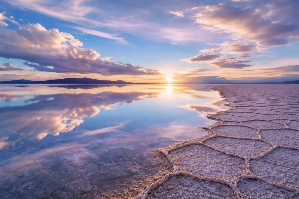
Then, the rains come. Between December and April, the dry, cracked desert begins to disappear. A thin layer of water—often only a few centimeters deep—flows from nearby rivers and lakes onto the perfectly flat surface of the salt flat. Because the ground is so impermeable and level, the water doesn’t soak in or pool in deep spots; it just sits there, creating a gigantic, shallow puddle. And this is when the true magic happens.
This shallow water turns the Salar de Uyuni into the world’s largest mirror, stretching over 80 miles across. The effect is so perfect that the horizon vanishes. The sky above, with its fluffy clouds and brilliant blue, reflects so clearly on the water that it becomes nearly impossible to tell where the Earth ends and the sky begins. Visitors often describe it as walking on air or floating through the clouds.
The physics behind this mirror effect is fascinating. For a surface to act as a perfect mirror, it must be incredibly smooth. The Salar’s salt crust, when flooded, creates a surface that is smooth at the scale of light waves. Any ripples would scatter the light and blur the reflection, but under perfectly calm conditions, with no wind, the water layer becomes optically flat. The light rays bounce off the water at the same angle they arrived, creating a mirror image that is virtually indistinguishable from the real sky.
This effect is most dramatic during sunrise and sunset. Imagine standing in water that reflects the sky so perfectly that you seem to be floating in clouds while the sun paints everything in shades of orange, pink, and purple both above and below you. Photographers from around the world flock to the Salar during these months to capture images that look like they belong in a dream.
It’s also the time for creative photography. Because there are no reference points in the reflection, you can play with perspective in ways that are impossible anywhere else. Tour groups spend hours taking photos where one person appears to be standing on another’s hand, or where a toy dinosaur looks like a giant monster attacking the group. The lack of depth perception in the photos creates optical illusions that delight visitors and produce images that go viral on social media.
Recent scientific studies have finally put a number on just how smooth this mirror is. Using radar data from the European Space Agency’s Sentinel-3 satellites, researchers discovered that when the Salar is flooded with perfectly calm water, it becomes what they call a radar-smooth surface. In February 2024, a field team ventured onto the salt flat during a satellite overpass and confirmed that the water was a mere 1.8 centimeters deep and as flat as glass. The radar signal bounced back with a strength of 120 plus or minus 0.3 dBsm, which is essentially the theoretical maximum for a perfect mirror. For a few weeks each year, the Salar de Uyuni is the flattest place on Earth.
But the wet season also presents challenges. The same water that creates the mirror can make travel difficult or impossible. Four-wheel-drive vehicles must navigate carefully, following routes that drivers know are safe. Getting stuck in the mud at the edge of the salt flat is a real risk. And sometimes, heavy rains can make the entire Salar inaccessible for days at a time. Tour operators monitor weather forecasts closely and may cancel trips if conditions are too dangerous.
Despite these challenges, visitors who time their trip right and get lucky with calm weather experience something truly unforgettable. There are only a handful of places on Earth where you can witness such a phenomenon, and none on this scale. The Salar during the wet season is a reminder that our planet still holds wonders that defy explanation and can only be experienced firsthand.
Chapter 5: A High-Tech Tool: Why Satellites Love This Place
Its beauty is enough to draw tourists from around the globe, but the Salar’s incredible flatness and stability serve a much more high-tech purpose. It is one of the most important natural calibration sites for Earth-observing satellites in the world. Think of it as a giant, natural test pattern for the most advanced cameras and altimeters in space.
Here’s why it’s so perfect for the job:
Flatness is the primary reason. The average elevation across the entire 4,000-square-mile area varies by less than one meter. For a satellite trying to measure the exact height of an ocean or an ice sheet, having a known, perfectly flat spot on the ground to check its instruments against is invaluable. It’s like a tailor using a perfectly flat table to measure fabric—if the table is warped, the measurements will be wrong.
Scientists call this process vicarious calibration. Instead of calibrating instruments in a lab before launch, they use natural features on Earth to check and adjust the measurements after the satellite is in orbit. The Salar is ideal for this because it’s large enough that a satellite can see it clearly, flat enough that scientists know exactly what elevation to expect, and stable enough that it doesn’t change much over time.
High reflectivity is another crucial factor. The bright white salt reflects sunlight extremely well, which is great for calibrating optical instruments that measure light and color. Scientists call this absolute radiometric calibration. If a satellite’s readings are off by even a tiny bit, it could change how we interpret data about forest health, crop irrigation needs, or ocean temperatures.
Imagine you’re trying to measure the greenness of a forest from space. If your instrument thinks a perfectly white surface is slightly gray, then your forest measurements will be wrong too. By pointing the satellite at the Salar, scientists can check exactly what the instrument sees when it looks at something they already understand perfectly. Any errors in the reading can be corrected, ensuring that all the data the satellite collects is accurate.
Stability and size also matter. The Salar is huge, stable, and located in a dry, high-altitude area with very little atmosphere in the way. The thin atmosphere means less interference from water vapor and air molecules that can scatter light and distort measurements. This combination makes it about five times better for calibration than the surface of the ocean. Missions like NASA’s ICESat have used it to achieve elevation measurement accuracy of less than 2 centimeters.
Different satellites use the Salar for different purposes. Radar satellites use it to check their ability to measure elevation. Optical satellites use it to check their color sensors. Even satellites that measure Earth’s gravity field use the Salar as a reference point because its mass is so consistent and well-understood. Every major space agency—NASA in the United States, ESA in Europe, JAXA in Japan, and others—has used the Salar de Uyuni for calibration at some point.
However, even this perfect spot can have an off day. In early 2022, extreme weather caused heavy flooding that washed sediment from the surrounding mountains onto the salt flat. Satellite images showed the brilliant white replaced by swirls of brown and green, caused by the sediment and resulting algae blooms. For a while, the mirror was dirty, and scientists had to wait for it to dry out and return to its pristine white state to resume calibration work.
This event taught scientists something important. The Salar is not as unchanging as they once thought. Climate change could bring more extreme weather events that alter the surface more frequently. Scientists are now monitoring the Salar more closely, watching for changes that might affect its usefulness as a calibration target. They’re also using the Salar to study these weather events themselves, learning how sediment moves across the landscape and how ecosystems respond to extreme flooding.
Chapter 6: The Treasure Below: A World Leader in Lithium
Beyond its beauty and scientific utility, the Salar de Uyuni holds another secret: it sits on top of one of the largest reserves of lithium in the world. Lithium is a soft, silvery-white metal that is a critical component in the rechargeable batteries that power our laptops, smartphones, and electric vehicles. Because of this, the Salar is at the heart of the global Lithium Triangle.
The lithium isn’t in the solid salt crust itself, but dissolved in the brine that lies underneath. The concentration here is about 0.3%, which is high enough to be commercially valuable. Estimates suggest that Bolivia holds about 22% of the world’s known lithium resources, with the vast majority located under the Salar de Uyuni. That’s enough lithium to build billions of electric car batteries.
How did all this lithium get here? The same way the salt got here. For millions of years, hot springs and volcanic activity in the surrounding mountains released lithium from deep within the Earth. Rivers carried this dissolved lithium down into the ancient lakes. As the lakes evaporated, the lithium concentrated in the remaining brine. Today, the brine under the Salar is like a giant underground ocean of liquid battery material.
This has put Bolivia in a unique position. For decades, there has been a global race to extract this white gold. As the world moves toward electric vehicles and renewable energy storage, demand for lithium is skyrocketing. Automakers are scrambling to secure supplies, and countries with large lithium deposits suddenly find themselves holding a valuable resource.
However, the story of lithium in Bolivia is complicated. In the 1980s and 1990s, foreign companies attempted to build mining operations, but they faced strong opposition from local communities who were worried that the profits would leave the country and that mining would damage their sacred and beautiful landscape. The indigenous people of the region have lived here for centuries, and they see the Salar as more than just a resource to be exploited.
The Bolivian government has historically been cautious, wanting to control its own resources. Instead of letting foreign corporations take over, they have aimed to develop their own lithium industry, though it has been a slow and challenging process. Building a lithium industry from scratch is difficult. It requires advanced technology, skilled workers, and massive investment. Bolivia has struggled to attract partners on terms that satisfy both the government and local communities.
The lithium here is also mixed with more impurities like magnesium, making it harder and more expensive to process than in neighboring Chile. Chilean lithium comes from salt flats where the brine is purer and the weather is drier, allowing for faster evaporation. In Bolivia, the rainy season slows down the evaporation process, and the magnesium must be removed through additional chemical steps.
So, while the Salar’s surface is a place of serene beauty, what lies beneath is a source of intense economic and political interest. The Bolivian government has signed agreements with Chinese and Russian companies to help develop the lithium industry, but large-scale production has been slow to materialize. Meanwhile, the world watches and waits, knowing that the future of electric vehicles may depend in part on what happens in this remote corner of Bolivia.
Local communities have mixed feelings about lithium development. Some see it as a path to jobs and prosperity. Others worry about the environmental impact. Extracting lithium requires pumping brine to the surface and letting it evaporate in huge ponds, which could potentially affect the delicate balance of the ecosystem. The flamingos that breed in nearby lagoons depend on specific water conditions, and any change could threaten their survival.
Chapter 7: Life on the Salt: Flamingos and Other Survivors
It might seem impossible for anything to live in such a harsh, salty environment, but the Salar de Uyuni and its surrounding areas are teeming with life. The real hotspots are the lagoons that sit on the edges of the salt flat, particularly the stunning Laguna Colorada and Laguna Verde.
Laguna Colorada, or Red Lagoon, is a shallow salt lake that gets its striking red color from algae and sediments that thrive in its mineral-rich waters. The algae produce pigments to protect themselves from the intense ultraviolet radiation at this altitude, and those pigments turn the water various shades of red, orange, and brown. Depending on the light and the time of day, the lagoon can look like a scene from Mars, with water the color of rust against the white salt and blue sky.
And where there’s algae, there’s food. This lagoon is a major breeding ground for three species of South American flamingos: the Andean flamingo, the James’s flamingo, and the Chilean flamingo. Every November, thousands of these elegant pink birds gather here to nest and feed, creating a breathtaking spectacle of color against the stark red water and white salt borders.
The flamingos get their pink color from the same algae that colors the lagoon. They filter the water through their specialized beaks, straining out tiny shrimp and algae that contain pigments called carotenoids. The more they eat, the pinker they become. During the breeding season, their colors intensify as they prepare to attract mates and raise their young.
These flamingos are specially adapted to life at high altitude. They can fly at 15,000 feet, higher than most birds, and they have special mechanisms in their legs to prevent heat loss in the cold Andean nights. They build cone-shaped mud nests to protect their eggs from the salt and wind, and both parents take turns incubating the eggs and feeding the chicks.
The Andean flamingo is the rarest of the three species, with only about 38,000 individuals left in the world. Most of them breed here in Bolivia, making the protection of these lagoons critical for the species’ survival. Conservationists monitor the flamingo populations closely, counting nests and tracking migration patterns to understand how climate change and human activity might be affecting them.
In the drier areas around the salt flat, you can spot other hardy creatures. Vizcachas, which look like a cross between a rabbit and a chinchilla with long tails, can be seen sunbathing on rocky outcrops. These relatives of the chinchilla are perfectly adapted to the harsh conditions, with thick fur that keeps them warm at night and large ears that help them release heat during the day.
Herds of llamas and alpacas, domesticated by local communities for centuries, graze on the tough grasses of the high-altitude plains. These animals are essential to the local economy, providing wool, meat, and transportation. The Quechua and Aymara people who live here have bred them for thousands of years, selecting for traits that help them survive in this challenging environment.
The shy Andean fox, known locally as the culpeo, might dart across the road in front of your vehicle. These opportunistic predators eat rodents, birds, and whatever else they can find. They’re cautious around humans but can sometimes be spotted at dawn or dusk hunting along the edges of the salt flat.
Even in the salt itself, life finds a way. Scientists have discovered microorganisms living within the salt crystals, tiny bacteria and archaea that tolerate extreme salinity, intense UV radiation, and freezing temperatures. These extremophiles are of great interest to astrobiologists who study the possibility of life on other planets. If life can survive here, in conditions that resemble those on Mars, then maybe it could survive there too.
Chapter 8: A Journey Through Time: The Train Cemetery and Salt Hotels
A visit to the Salar de Uyuni is not just about nature; it’s also a trip through human history. Just outside the town of Uyuni lies one of the region’s most bizarre and photogenic attractions: the Train Cemetery.
In the late 19th and early 20th centuries, Uyuni was a bustling railway hub. The discovery of vast mineral deposits in the surrounding mountains created a boom in mining for silver, tin, and other metals. But Bolivia is a landlocked country, and getting those minerals to market required a railroad to the Pacific coast.
British engineers were brought in to build an extensive rail network. They brought locomotives and rail cars from England, shipped them across the Atlantic, up the coast of South America, and then laboriously hauled them up to the altiplano. The railroad was a marvel of engineering, crossing mountains, canyons, and salt flats to connect Bolivia’s mines with the ports of Chile.
The trains ran for decades, carrying minerals to the coast and bringing manufactured goods back to Bolivia. Uyuni became a thriving railroad town, with hotels, restaurants, and a cosmopolitan atmosphere unusual for this remote region. Engineers, miners, and merchants from around the world passed through its streets.
But by the 1940s, the mining industry collapsed. The tin mines played out, and world demand for Bolivian minerals decreased. The railroad company went bankrupt, and many of the steam locomotives and rail cars were simply abandoned in a desert yard a few miles from town. Left to rust in the dry air and intense sun, they became a graveyard of mechanical dinosaurs.
Today, the cementerio de trenes is an open-air museum. The rusty, decaying hulks of these once-mighty machines contrast sharply with the brilliant blue sky and the distant white of the salt flat. It’s a hauntingly beautiful spot that feels like the set of a post-apocalyptic movie. In fact, it was used in the filming of Star Wars: The Last Jedi, where it stood in for the planet Crait.
Walking among the trains, you can still see the details of their construction: the brass fittings, the steam gauges, the couplings that once connected them to long strings of ore cars. Graffiti covers some of the cars, added by visitors over the years. The desert wind whistles through their hollow frames, and the salt dust coats everything with a fine white powder.
The trains are slowly deteriorating. Without maintenance, they’ll eventually collapse into piles of rust. Some people have proposed preserving them, while others argue that their decay is part of their charm. For now, they remain as they were left, a monument to a forgotten era of industry and ambition.
After a day of exploring the train cemetery and the salt flat, many visitors choose to stay in one of the region’s famous salt hotels. The idea started in the 1990s when a hotel was built in the middle of the salt flat entirely out of salt blocks. Though that first hotel had to be torn down due to pollution concerns, new ones have been built on the edge of the Salar.
These hotels, like the famous Palacio de Sal, are constructed from hundreds of thousands of salt blocks. The blocks are cut from the Salar itself during the dry season, then stacked like giant bricks to form walls. Water is sprayed on them, which dissolves a little salt and then recrystallizes, bonding the blocks together into solid walls.
The experience of staying in a salt hotel is unique. The walls, the floors, the beds, the tables, and even the sculptures are all made of salt. The beds have mattresses on top of salt platforms, and the furniture is solid salt. The rule is simple: don’t lick the furniture. But you can run your hand along the walls and feel the rough crystalline texture, and you can look up at ceilings made of salt blocks.
These hotels are surprisingly comfortable. The salt helps regulate temperature, staying cool during the hot day and releasing warmth slowly at night. They’re well-insulated against the cold Andean nights, and the salt walls create a peaceful, quiet atmosphere. Waking up in a room made of salt, looking out at the endless white expanse through a window framed in salt, is an experience you won’t find anywhere else on Earth.
Chapter 9: The People of the Salt: Culture and Tradition
The Salar de Uyuni is not just a natural wonder; it’s also home to indigenous communities who have lived here for centuries. The Aymara and Quechua people have adapted to this harsh environment, developing unique cultures and traditions centered around the salt and the resources it provides.
Long before the Spanish arrived, the people of this region traded salt with communities throughout the Andes. Salt was essential for preserving food and for human health, and the Salar was the largest source in the southern Andes. Caravans of llamas carried salt blocks across mountain passes to the jungles of the east and the coast of the Pacific, exchanging it for coca leaves, maize, and other goods.
Today, salt harvesting continues, though on a smaller scale. Local families have rights to harvest salt from certain areas of the Salar. They use traditional methods, scraping the salt into piles, letting it dry, then cutting it into blocks or grinding it for sale. The salt is sold throughout Bolivia and exported to other countries, prized for its purity and its origin.
The people also raise llamas and alpacas, which are perfectly adapted to the high-altitude environment. These animals provide wool for weaving, meat for food, and leather for various uses. The weaving traditions here are ancient, with patterns and techniques passed down through generations. The women weave colorful textiles using wool from their own animals, dyed with natural pigments from local plants and minerals.
The communities around the Salar have their own beliefs and traditions related to the salt. They see the Salar as a living entity, a place of power and meaning. In Aymara cosmology, the mountains are protective spirits called apus, and the Salar is their creation. Offerings are still made to the Pachamama, or Earth Mother, asking for protection and abundance.
These traditions mix with Catholicism in fascinating ways. The Spanish brought their religion, but the indigenous people adapted it to their own beliefs. In the village churches around the Salar, you’ll see saints dressed in traditional Andean clothing, and rituals that blend Catholic and indigenous elements. During festivals, dancers wear elaborate costumes and masks, performing dances that tell stories of conquest, resistance, and survival.
Tourism has brought changes to these communities. Young people who might have left for the cities now have opportunities to work as guides, drivers, and hotel staff. But it also brings challenges. How do you preserve traditional ways of life while welcoming thousands of visitors each year? How do you share your culture without exploiting it?
Some communities have chosen to develop their own tourism projects, building small hostels and offering tours that showcase their traditions. Visitors can stay with families, learn to weave, help with the salt harvest, and eat traditional foods. These community-based tourism projects aim to share the benefits of tourism more equitably and to give visitors a deeper understanding of life on the salt.
Chapter 10: The Active Volcanoes: Guardians of the Salar
The Salar de Uyuni is surrounded by volcanoes, many of them still active. These mountains are not just scenic backdrops; they’re an integral part of the Salar’s story. They provided the minerals that formed the salt flat, and they continue to shape the landscape today.
To the west, along the border with Chile, a chain of volcanoes rises to over 6,000 meters. The most famous is Licancabur, a perfect cone that dominates the horizon. Its summit crater contains one of the highest lakes in the world, at nearly 6,000 meters above sea level. Despite the extreme cold and thin air, this lake contains life—microorganisms that have adapted to conditions similar to those on early Mars.
Licancabur is sacred to the indigenous people. Its name means people’s mountain in the Kunza language. Archaeological remains found near its summit suggest that the Inca conducted ceremonies here, climbing to the edge of the crater to make offerings. The mountain was a link between earth and sky, a place where humans could approach the gods.
Other volcanoes in the chain include Ollagüe, which still emits plumes of steam from its summit, and Tunupa, which stands alone on the northern edge of the Salar. Tunupa has its own legend. According to Aymara tradition, Tunupa was a goddess who traveled through the Andes teaching people how to live. When she was betrayed by those she tried to help, she wept tears that mixed with her milk to form the salt flat. Her body became the mountain that watches over the Salar today.
These volcanoes are not just part of the past; they’re part of the present. Scientists monitor them for signs of activity, knowing that an eruption could have serious consequences for the communities around the Salar. The volcanoes also provide opportunities for adventure travelers who want to climb to their summits and look down on the salt flat from above.
The high altitude makes these climbs challenging. Even getting to the base camp requires acclimatization, and the final push to the summit can be exhausting. But those who make it are rewarded with views that few people ever see: the Salar spread out below like a white ocean, the chain of volcanoes stretching to the south, and the deep blue of the high-altitude sky above.
Between the volcanoes and the Salar lie the altiplano plains, home to vicuñas and viscachas, and dotted with small villages where life continues much as it has for centuries. Here, you can see traditional farming terraces still in use, irrigation canals built by pre-Inca peoples, and the ruins of ancient settlements that once thrived in this harsh environment.
Chapter 11: Planning Your Visit: When to Go and What to Know
Deciding when to visit the Salar de Uyuni depends entirely on what you want to experience. Each season offers a completely different, but equally amazing, adventure.
If your dream is to see the mirror effect, you need to visit during the rainy season, from December to April. January and February are typically the best months for the most dramatic reflections. However, this comes with a trade-off. Heavy rains can sometimes make parts of the salt flat inaccessible, and you might not be able to reach places like Isla Incahuasi. Tours still run, but the itinerary may be adjusted for safety, as driving across a giant mirror can be tricky.
During the rainy season, the weather is warmer but also more unpredictable. Afternoon thunderstorms are common, and the skies can change from brilliant blue to dark gray in minutes. The mirror effect requires calm conditions; even a light breeze can ripple the water and blur the reflection. The best times for photography are early morning and late afternoon, when the wind is usually calmest and the light is most dramatic.
If you want to explore the entire region, drive to the cactus island, and see the famous hexagonal salt patterns, then the dry season from May to November is for you. The weather is cooler, the skies are incredibly clear, and you can drive anywhere. The downside? No mirror. You get to see the vast, textured, blinding white desert instead.
During the dry season, temperatures can drop below freezing at night, especially from June to August. Days are sunny and pleasant, but you’ll need warm clothing for the evenings and early mornings. The clear skies make for spectacular stargazing, and many tours offer night excursions onto the salt flat to see the Milky Way reflected in the dry salt.
Getting to Uyuni is relatively straightforward. You can fly from La Paz to the small airport at Uyuni, a short flight that offers spectacular views of the Andes. Alternatively, you can take a bus from La Paz or from cities in Chile and Argentina. The bus ride is long, often 10 to 12 hours, but it’s an adventure in itself, winding through mountain passes and past spectacular scenery.
Once in Uyuni, you’ll find dozens of tour agencies offering trips to the salt flat. Prices vary widely, and it’s worth doing some research to find a reputable company. The cheapest tours may cut corners on safety, food quality, or driver experience. Look for agencies that are well-established, with good reviews and proper equipment.
A standard tour lasts three days and covers not just the Salar but also the surrounding lagoons, geysers, and hot springs. You’ll travel in a 4×4 vehicle with a driver-guide and typically five to six passengers. Meals are included and are often surprisingly good, with hot soups, fresh vegetables, and meat prepared by the guide.
Accommodation on the tour ranges from basic hostels to the salt hotels. The basic option involves shared rooms with no heating, which can be very cold at night. The salt hotels are more comfortable, with private rooms and sometimes even hot water for showers. In either case, be prepared for cold nights and bring a warm sleeping bag if you have one.
Altitude is a serious consideration. Uyuni is at 12,000 feet, and parts of the tour go above 16,000 feet. Altitude sickness can affect anyone, regardless of age or fitness. Symptoms include headache, nausea, dizziness, and shortness of breath. Take it easy for the first day or two, drink plenty of water, avoid alcohol, and consider chewing coca leaves or drinking coca tea, a traditional remedy that really does help.
Packing smart is essential. The weather can change in an instant. You need sunscreen and sunglasses to protect against the intense sun, but also warm layers, a hat, and gloves for the cold. The glare off the salt is intense, so good sunglasses are non-negotiable. A hat with a brim will protect your face from the sun, and lip balm with SPF will prevent your lips from cracking in the dry air.
Camera equipment requires special consideration. The salt dust gets everywhere and can damage camera gear. Bring a protective bag or case, and be careful when changing lenses. A polarizing filter can help cut through the glare and enhance colors, especially during the mirror season. And bring extra batteries; the cold drains them quickly.
Chapter 12: Beyond the Salar: The Greater Altiplano Experience
While the Salar de Uyuni is the main attraction, the surrounding altiplano offers its own wonders. Most tours include these areas, giving visitors a complete picture of this unique region.
South of the Salar lies the Eduardo Avaroa Andean Fauna National Reserve, a protected area that contains some of the most spectacular scenery in Bolivia. Here you’ll find Laguna Verde, a stunning green lake at the base of the Licancabur volcano. The green color comes from high concentrations of arsenic and other minerals, and the lake’s color changes throughout the day depending on the wind and light.
Nearby, the Sol de Mañana geyser field bubbles and steams with volcanic activity. Early in the morning, when the air is coldest, the steam rises in dramatic columns against the rising sun. The ground here is hot, and you have to stay on marked paths to avoid breaking through the thin crust into boiling mud below. The smell of sulfur is strong, a reminder that you’re standing on an active geothermal area.
Hot springs offer a chance to soak in naturally heated water while surrounded by snow-capped peaks. The Polques hot springs are a popular stop, with pools where you can relax and watch the sunset paint the mountains in shades of gold and red. The contrast between the hot water and the cold air is invigorating, and there’s nothing quite like soaking in a natural hot spring at 14,000 feet.
The rock formations of the altiplano are equally impressive. The Arbol de Piedra, or Stone Tree, is a famous rock formation shaped by wind erosion into the form of a petrified tree. It stands alone on the plain, a testament to the power of wind and time. Other rock formations create natural shelters that were used by ancient peoples and still show evidence of their occupation.
Wildlife viewing in the reserve is excellent. Besides the flamingos, you might see vicuñas, the wild ancestors of alpacas, grazing on the tough grasses. These elegant animals have the finest wool in the world, and they were once hunted to near extinction for it. Today, they’re protected, and their populations are recovering. You might also see rheas, large flightless birds related to ostriches, running across the plain.
The return journey to Uyuni often passes through the village of San Cristóbal, where a massive silver-zinc mine operates. The contrast between the traditional village life and the modern industrial mine is striking. The mine has brought jobs and development but also controversy, as some community members worry about environmental impacts and the distribution of benefits.
Chapter 13: A Delicate Balance: Tourism, Science, and Conservation
The Salar de Uyuni is a place of incredible value—aesthetic, scientific, and economic. Balancing these different interests is a challenge for Bolivia. Tourism brings money and jobs to local communities. The lithium under the ground offers a path to economic development. And the scientific community relies on its pristine conditions for crucial Earth-monitoring work.
Tourism has grown rapidly in recent years. In 2005, about 60,000 people visited the Salar. By 2019, that number had grown to over 400,000. The COVID-19 pandemic caused a temporary drop, but numbers are climbing again. This growth brings opportunities and challenges. More tourists mean more jobs for guides, drivers, and hotel workers. But it also means more pressure on the fragile environment.
The salt crust is surprisingly delicate. Vehicles driving off the designated routes can damage the surface, creating ruts that take years to heal. Garbage and human waste can contaminate the brine and harm wildlife. Tour operators and park authorities work to minimize these impacts, educating visitors and enforcing rules about staying on marked routes and packing out all waste.
The recent 2022 event, where floods turned the Salar brown, was a perfect example of its fragility. While the discoloration was a temporary, natural event, it showed how quickly this perfect mirror can change. Scientists are now using satellites like Sentinel-3 to monitor these changes over time. By tracking how the smoothness of the surface changes, they can learn about rainfall patterns, evaporation rates, and the impacts of climate change on this high-altitude desert.
Climate change poses a real threat to the Salar. Changes in rainfall patterns could alter the timing and extent of the flooding that creates the mirror effect. Warmer temperatures could increase evaporation, affecting the brine below the surface. And more extreme weather events, like the 2022 floods, could become more common, potentially changing the Salar in ways we can’t predict.
There are also concerns about the environmental impact of lithium mining. Extracting lithium involves pumping vast amounts of brine to the surface and letting it evaporate in huge ponds. This process could potentially lower the water table and disrupt the delicate ecosystem that supports the flamingos and other wildlife. The brine contains not just lithium but also other minerals, and the waste products from processing need to be disposed of carefully.
Finding a way to mine the lithium responsibly, without destroying the very things that make the Salar special, is one of the biggest challenges Bolivia faces today. Some proposed methods use less water and create less waste, but they’re more expensive and less proven. The Bolivian government says it’s committed to sustainable development, but the pressure to produce lithium quickly is intense.
Conservation groups are working to protect the Salar and its surrounding ecosystems. They monitor wildlife populations, study the impacts of tourism and mining, and work with local communities to find sustainable solutions. The flamingo populations are a particular focus, as these birds depend on the specific conditions of the altiplano lagoons. Any change to those conditions could have devastating effects.
Chapter 14: The Future of the Salar
What does the future hold for the Salar de Uyuni? That depends on choices made today by governments, businesses, local communities, and visitors like you.
If lithium development proceeds carefully, with strong environmental protections and benefits for local people, it could bring prosperity without destroying what makes the Salar special. Bolivia could become a major player in the global transition to electric vehicles, using its natural resources to build a more sustainable future.
If tourism continues to grow sustainably, with well-managed tours and educated visitors, it could provide lasting economic opportunities for communities around the Salar. The key is to focus on quality over quantity, attracting visitors who appreciate the Salar’s unique qualities and are willing to respect it.
If climate change is addressed globally, the Salar might continue its ancient cycles of wet and dry for millennia to come. If not, the changes could be dramatic and unpredictable. The Salar has survived for thousands of years, but the rapid warming of the past century is unlike anything in its history.
Scientists will continue to use the Salar for calibration, watching it change and learning from it. Each satellite pass gives them new data about this remarkable place, and each new discovery adds to our understanding of how the Earth works. The Salar is not just a beautiful landscape; it’s a scientific treasure.
For visitors, the Salar will continue to offer experiences that can’t be found anywhere else. Whether walking on clouds during the wet season or exploring geometric patterns during the dry season, people will come here to witness one of Earth’s most extraordinary places. And they’ll leave with memories that last a lifetime.
Chapter 15: Practical Wisdom for Travelers
Before you go, there are some practical things to know that will make your visit better. These tips come from travelers who’ve been there and learned the hard way.
Cash is essential in Uyuni. There are ATMs, but they often run out of money or don’t accept foreign cards. Bring enough Bolivian pesos to pay for your tour and any extras you might want. Most places don’t accept credit cards, and even if they do, the connection might be unreliable.
Spanish is helpful but not essential. Many tour guides speak English, especially with the larger agencies. But knowing a few basic phrases will make your experience richer and help you connect with local people. Simple words like gracias, por favor, and cómo estás go a long way.
Be flexible with your plans. Weather in the altiplano is unpredictable, and tours can be delayed or rerouted. If you have a tight schedule, build in an extra day or two as a buffer. The Salar operates on its own timetable, not yours.
Respect local customs. Ask permission before taking photos of people, especially in villages. Dress modestly when visiting churches or communities. And remember that for the people who live here, this is home, not just a tourist attraction.
Travel insurance is a good idea. At high altitude, medical issues can arise unexpectedly. If you need to be evacuated, the costs can be enormous. Make sure your insurance covers high-altitude activities and medical evacuation.
Finally, take time to simply be present. Put down your camera occasionally and just look. Watch the light change on the salt. Listen to the silence, which is deeper than anywhere else on Earth. Feel the crunch of salt under your feet. The photos will be there, but the feeling of being in this place is something you can only capture with your own senses.
Chapter 16: The Salar in Popular Culture
The Salar de Uyuni has captured imaginations around the world, appearing in films, music videos, and art. Its otherworldly landscapes make it a favorite location for creators seeking something truly unique.
Most famously, the Salar served as the backdrop for the planet Crait in Star Wars: The Last Jedi. The scenes where the Resistance speeds across a white plain, leaving red trails behind them, were filmed here. The red came from colored flares placed under the vehicles, creating the illusion of a planet with a white salt surface over red mineral earth. The Train Cemetery also appears in the film, standing in for a Rebel base.
Music videos have been filmed here, using the mirror effect to create stunning visuals. Björk’s video for Hollow used the Salar’s reflective surface to create dreamlike imagery. Other artists have followed, drawn by the Salar’s ability to create visuals that can’t be reproduced in a studio.
Fashion photographers love the Salar for its minimalist backdrop. The endless white provides a canvas that makes clothing and models stand out dramatically. Magazine spreads shot here have won awards and inspired countless imitations.
Documentaries about the Salar explore its science, its beauty, and its challenges. The BBC, National Geographic, and other major producers have all featured it, bringing its story to audiences around the world. These documentaries have helped raise awareness of the Salar’s importance and the threats it faces.
Social media has made the Salar more famous than ever. Instagram is filled with photos of the mirror effect, creative perspective shots, and sunsets over the salt. The Salar has become a bucket-list destination for travelers seeking the perfect photo. This visibility brings more visitors but also spreads awareness of this remarkable place.
Chapter 17: Scientific Discoveries and Ongoing Research
The Salar de Uyuni continues to be a site of important scientific research. Scientists from around the world come here to study everything from climate history to extremophile life forms.
One of the most exciting areas of research involves the salt itself. By drilling cores deep into the salt crust, scientists can read the history of climate change going back hundreds of thousands of years. Each layer of salt represents a year or a season, and the chemicals trapped in those layers tell stories of droughts, floods, and temperature changes. This record is one of the longest and most detailed in the Southern Hemisphere.
Recent studies have focused on the microorganisms living within the salt. These extremophiles have adapted to survive in conditions of extreme salinity, high UV radiation, and freezing temperatures. Scientists are studying their DNA to understand how they do it, with potential applications in medicine, industry, and even space exploration. If life can survive here, maybe it could survive on Mars.
The brine beneath the salt is also being studied intensively. Researchers are mapping its chemistry, its depth, and how it moves. This information is crucial for understanding the lithium resource, but it also tells us about the geological processes that shape the Salar. The brine is not static; it moves and changes in response to rainfall, evaporation, and even seismic activity.
Satellite monitoring of the Salar continues to provide valuable data. The European Space Agency’s Sentinel satellites pass over regularly, measuring the surface elevation, the extent of flooding, and the color of the salt. This long-term dataset allows scientists to track changes over time and to understand the Salar’s response to climate variability.
Archaeologists are also active in the region, studying the ancient cultures that lived around the Salar. New discoveries are made regularly, from previously unknown tomb sites to artifacts that shed light on how people adapted to this challenging environment. The salt itself was a valuable resource that supported trade networks stretching across the Andes.
Chapter 18: The Spiritual Significance of the Salar
For the indigenous people of the region, the Salar de Uyuni is far more than a tourist attraction or a source of minerals. It is a sacred place, deeply woven into their spiritual beliefs and cultural identity.
In Aymara cosmology, the world is divided into different realms. The sky world, or alaxpacha, is home to the sun, moon, and stars. The inner world, or manqhapacha, is the realm of ancestors and the earth. The Salar, lying between the mountains and the sky, is seen as a place where these worlds meet. It is a threshold, a place of connection between the human and the divine.
The mountains surrounding the Salar are considered apus, protective spirits that watch over the land and its people. Tunupa, the mountain on the northern edge, is particularly important. According to tradition, Tunupa was a powerful deity who traveled through the Andes teaching people how to live in harmony with the earth. When she was betrayed and killed, her body became the mountain, and her milk and tears became the salt.
Offerings are still made to Tunupa and to the Pachamama, or Earth Mother. These offerings, called ch’allas, involve burying or burning small items like coca leaves, alcohol, and incense. They are made at important times of the year, such as the beginning of the planting season or before a long journey. Even some tour guides make offerings before driving onto the Salar, asking for protection and safe passage.
The Salar is also associated with fertility and abundance. The salt itself is seen as a gift from the earth, a source of life and sustenance. Salt from the Salar is used in traditional ceremonies, sprinkled on the ground as an offering or used in healing rituals. Some people believe that the salt has protective properties and keep small bags of it in their homes.
For visitors, understanding this spiritual dimension adds depth to the experience. The Salar is not just a beautiful landscape; it is a place where people have found meaning and connection for thousands of years. Walking on the salt, you are walking on sacred ground.
Chapter 19: The Salt Harvesters: A Dying Tradition
While tourism and lithium grab the headlines, a quieter tradition continues on the edges of the Salar: the harvest of salt for human consumption. This ancient practice has sustained families for generations, but it is slowly dying out as younger people seek other opportunities.
The salt harvesters, or salineros, come from families that have worked the salt for centuries. They know the Salar intimately, understanding where the purest salt can be found and when the conditions are right for harvesting. Their knowledge is passed down through generations, an oral tradition that connects them to their ancestors.
The harvest process is labor-intensive. Using simple tools, the salineros scrape the top layer of salt into small piles. These piles are left to dry in the sun for several days, then loaded onto trucks or llama caravans and taken to processing areas. There, the salt is ground, sometimes iodized, and packaged for sale.
Most of the salt is sold within Bolivia, but some is exported to other countries. It is prized for its purity and its origin, and some gourmet markets in Europe and North America carry Bolivian salt from the Salar de Uyuni. The salt is often sold in its natural state, with no additives, appealing to consumers who want unprocessed foods.
But the salt harvesters face challenges. The price of salt is low, and it takes a lot of work to make a living. Young people see better opportunities in tourism or in the cities, and few want to continue the hard, physical work of salt harvesting. The knowledge and traditions are at risk of being lost.
Some efforts are being made to preserve the tradition. Cooperatives have been formed to help salt harvesters get better prices for their product. Tourism initiatives allow visitors to see the harvest process and buy salt directly from the harvesters. And there is growing interest in traditional foods and artisanal products, which could create new markets for Salar salt.
For now, the salt harvesters continue their work, just as their ancestors did. On the edges of the Salar, you can still see them, bent over the white ground, gathering the gift of the earth. They are a living link to the past, a reminder that the Salar has sustained human life for thousands of years.
Chapter 20: The Geology of the Surrounding Region
The Salar de Uyuni is just one part of a larger geological story. The entire altiplano region is a fascinating laboratory for understanding how mountains form and how landscapes evolve.
The Andes are a relatively young mountain range, geologically speaking. They began to rise about 25 million years ago, when the Nazca tectonic plate started sliding under the South American plate. This process, called subduction, continues today, causing earthquakes and volcanic eruptions throughout the region.
As the mountains rose, they created a basin between the two main ranges. This basin, the altiplano, became a closed system with no drainage to the sea. Over millions of years, sediments and minerals washed down from the mountains accumulated here, creating the thick layers of salt and other deposits we see today.
The volcanoes of the Western Cordillera are a direct result of the subduction process. As the Nazca plate descends into the earth’s mantle, it melts, and the molten rock rises to the surface. This creates a chain of volcanoes parallel to the coast, stretching from Colombia all the way to Chile. Many of these volcanoes are still active, and some have erupted in historic times.
The salt flats themselves are technically called playas or salars. They form in arid regions where evaporation exceeds precipitation, allowing salts to accumulate. The Salar de Uyuni is the largest of hundreds of such features in the altiplano, but it’s not the only one. Nearby Salar de Coipasa is also substantial, and smaller salars dot the landscape throughout the region.
The geology of the region is not static. The mountains are still rising, the volcanoes are still active, and the salt is still accumulating. Every earthquake, every eruption, every rainfall changes the landscape in small ways. Over millions of years, these small changes add up to dramatic transformations.
Chapter 21: The Climate of the Altiplano
The climate of the altiplano is as extreme as its geology. At 12,000 feet above sea level, the rules of weather are different than what most people are used to.
Temperature is perhaps the most surprising feature. Despite being near the equator, the altiplano can be bitterly cold. The thin atmosphere doesn’t hold heat well, so temperatures drop rapidly after sunset. Winter nights from June to August often fall below freezing, while daytime temperatures can reach 70 degrees Fahrenheit or more. This dramatic swing, sometimes 50 degrees or more in a single day, is hard on both people and equipment.
Precipitation follows a distinct seasonal pattern. The rainy season from December to March brings most of the year’s moisture. Thunderstorms are common in the afternoons, building up over the mountains and then sweeping across the altiplano. These storms can be dramatic, with lightning, hail, and sudden downpours that turn dry arroyos into rushing rivers.
The dry season from April to November sees almost no rain. The skies are clear and blue day after day, and the air is incredibly dry. Humidity often drops below 10 percent, causing lips to crack and skin to dry out. This dry air, combined with the high altitude, means that evaporation is rapid. Any water that does appear quickly vanishes into the thirsty atmosphere.
Wind is a constant presence. During the dry season, strong winds sweep across the altiplano, picking up salt dust and creating whiteout conditions. These winds can make driving dangerous and photography difficult. During the rainy season, the winds are lighter, especially in the mornings, which is why that’s the best time for seeing the mirror effect.
The sun at this altitude is intense. With less atmosphere to filter it, ultraviolet radiation is much stronger than at sea level. Sunburn can happen in minutes, even on cool days. Sunglasses are essential not just for comfort but for protecting your eyes from the glare off the salt. A good hat and strong sunscreen are non-negotiable.
Chapter 22: The Night Sky: An Astronomer’s Paradise
When the sun goes down over the Salar de Uyuni, a different kind of show begins. With no light pollution, thin dry air, and an elevation that puts you above much of the atmosphere, the night sky here is one of the clearest on Earth.
On a moonless night, the Milky Way stretches from horizon to horizon, so bright that it casts shadows. You can see details in the galactic core that are invisible from most places on Earth. The stars don’t twinkle as much here because there’s less atmosphere to distort their light. They hang in the sky like fixed points of diamond light.
During the dry season, when the salt is dry, you can drive onto the Salar at night and set up for photography. The dark salt provides a perfect foreground for astrophotography, and the reflections in any remaining moisture create stunning effects. Many tour operators offer night excursions specifically for stargazing.
The Southern Hemisphere sky is different from what Northern Hemisphere visitors are used to. The familiar North Star is not visible here. Instead, the Southern Cross, or Crux, is the most prominent constellation. The Magellanic Clouds, two dwarf galaxies that orbit the Milky Way, are visible to the naked eye as fuzzy patches of light.
Planets are often visible, especially Venus, which can be so bright that it casts shadows. Jupiter and Saturn are easy to spot when they’re in the sky, and even Uranus and Neptune can be seen with binoculars on the clearest nights. Meteors are common, and during the right time of year, you might see a meteor shower with dozens of shooting stars per hour.
For photographers, the night sky offers endless possibilities. With a good camera and a tripod, you can capture images that show the Milky Way reflected in the salt, or time-lapse sequences that show the stars wheeling overhead. The darkness is so complete that you can even see the zodiacal light, a faint glow caused by sunlight reflecting off dust in the solar system.
Chapter 23: The Road to Uyuni: Journey Through the Andes
Getting to Uyuni is an adventure in itself. Whether you fly or take the bus, the journey offers spectacular views and a gradual introduction to the altitude.
The flight from La Paz is short, only about 45 minutes, but it’s one of the most scenic flights you’ll ever take. The plane flies over the high Andes, with snow-capped peaks visible out the window. As you descend toward Uyuni, you’ll see the salt flat spread out below, a white expanse that seems to go on forever. On clear days, you can see the pattern of hexagons from the air, and if it’s the rainy season, you might spot the mirror effect from above.
The bus ride is longer but more immersive. Buses leave La Paz in the evening and arrive in Uyuni the next morning. The route winds through mountain passes, past traditional villages, and alongside beautiful lakes. You’ll see how people live in the altiplano, with their stone houses, llama herds, and terraced fields. The road is paved for much of the way, but the last section into Uyuni can be rough, especially after rains.
Some travelers choose to come from Chile, crossing the border at San Pedro de Atacama. This route takes you through some of the most spectacular scenery in the Andes, with volcanoes, geysers, and colorful lakes along the way. It’s a popular route for adventurous travelers who want to combine the Atacama Desert with the Salar de Uyuni.
However you choose to arrive, the journey is part of the experience. The altiplano unfolds around you, revealing its secrets slowly. By the time you reach Uyuni, you’ll already have a sense of this remarkable region and the people who call it home.
Chapter 24: Uyuni Town: Gateway to the Salt
The town of Uyuni is small, dusty, and functional. It exists primarily to serve travelers heading to the salt flat, but it has its own character and charm.
The main street is lined with tour agencies, restaurants, and hostels. During the day, it’s bustling with activity as tours depart and return. At night, it quietens down, though you’ll still find restaurants open and travelers comparing notes over dinner.
The market is worth a visit, selling everything from fresh produce to llama wool sweaters. You can buy snacks for your tour, pick up any last-minute supplies, or just wander and absorb the local atmosphere. The market is busiest in the mornings, when local people come to shop.
The train station, though no longer active for passenger service, is a handsome building from the railroad era. Nearby, the railway museum has a small collection of photographs and artifacts from the days when Uyuni was a thriving railroad hub. It’s worth an hour if you have time.
The cemetery on the edge of town is unusual and worth a visit. Because the ground is too salty for burial, the dead are interred in above-ground vaults, creating a city of the dead that contrasts with the living town nearby. The colorful vaults and the quiet atmosphere make it a peaceful place for reflection.
Uyuni is not a beautiful town in the conventional sense. It’s dusty, windswept, and utilitarian. But it’s friendly and welcoming, and it serves its purpose well. Without Uyuni, accessing the Salar would be much more difficult. The town is the gateway, and it deserves appreciation for that role.
Chapter 25: The Impact of Climate Change
Climate change is affecting the Salar de Uyuni, just as it’s affecting every part of the planet. The changes are subtle now, but they could become dramatic in the coming decades.
One of the most significant changes is in the pattern of rainfall. The rainy season has become less predictable, with some years bringing too much rain and others too little. This affects the mirror effect, which depends on just the right amount of water. Too little, and the Salar doesn’t flood. Too much, and travel becomes impossible.
Temperature is also increasing. The altiplano is warming faster than the global average, a pattern seen in many high-elevation regions. This warming affects the glaciers on the surrounding mountains, which are shrinking rapidly. These glaciers feed the rivers that flow into the Salar, so their loss could reduce the water available during the rainy season.
Warmer temperatures also increase evaporation. This could concentrate the brine beneath the salt, potentially making lithium extraction easier but also affecting the delicate balance of the ecosystem. More evaporation means saltier water in the lagoons, which could harm the flamingos and other wildlife.
Extreme weather events may become more common. The 2022 floods that turned the Salar brown were a reminder that the system can change rapidly. If such events become more frequent, the Salar could spend more time in a discolored state, affecting both tourism and satellite calibration.
Scientists are monitoring these changes closely. The Salar is not just a beautiful place; it’s a sensitive indicator of climate change in the Andes. What happens here will tell us about the health of the entire region.
Chapter 26: The Flamingo Breeding Season
Every year, around November, the flamingos gather at Laguna Colorada for their breeding season. It’s one of the great wildlife spectacles of the Andes, and a highlight for visitors lucky enough to see it.
The courtship displays are elaborate. Groups of flamingos perform synchronized dances, stretching their necks, flapping their wings, and marching in formation. These displays strengthen pair bonds and synchronize breeding within the colony. The noise is incredible, with hundreds of birds calling at once.
Once pairs form, they build nests together. Using their beaks, they scoop mud into cone-shaped mounds about a foot high. The height protects the eggs from flooding and from the cold ground. Both parents work on the nest, adding mud and shaping it until it’s just right.
The female lays a single large egg, chalky white and about the size of a tennis ball. Both parents take turns incubating it, carefully positioning it on top of the nest mound. Incubation takes about a month, during which the parents rarely leave the nest.
When the chick hatches, it’s covered in gray down and has a straight beak. The parents feed it with crop milk, a nutritious fluid they produce in their digestive systems. The chick grows quickly, and within a few months, its beak begins to curve and its feathers start to turn pink.
The breeding season is a vulnerable time for the flamingos. Predators like Andean foxes and birds of prey target eggs and chicks. Human disturbance can cause parents to abandon their nests. Park rangers monitor the colonies closely, keeping visitors at a safe distance and ensuring that the flamingos can breed in peace.
Chapter 27: The Mystery of the Hexagons
The hexagonal patterns on the dry salt flat have fascinated visitors for centuries. How does nature create such perfect geometric shapes?
The process begins with evaporation. As the sun heats the salt flat, water below the surface turns to vapor and rises. This creates convection currents in the brine, similar to the currents that form in a pot of simmering soup. These currents organize themselves into hexagonal cells, with material rising in the center and sinking at the edges.
The salt crystals themselves play a role. As the brine becomes supersaturated, salt begins to crystallize. The crystals grow fastest at the edges of the convection cells, where the brine is most concentrated. Over time, this creates raised ridges that form the boundaries of the hexagons.
The size of the hexagons depends on the depth of the brine and the rate of evaporation. Deeper brine and slower evaporation create larger hexagons. Shallower brine and faster evaporation create smaller ones. This is why you see different sizes in different parts of the Salar.
When the salt flat dries completely, the raised ridges crack, creating the polygonal patterns we see. The next rainy season floods the salt, dissolving the ridges and resetting the process. Then the next dry season creates new patterns, slightly different from the year before.
This cycle has been repeating for thousands of years. Each year’s pattern is unique, a fingerprint of that year’s weather conditions. Scientists can read these patterns to understand past climate, just as tree rings reveal past growing seasons.
Chapter 28: The Brine: A Liquid Treasure
Beneath the solid salt crust lies a world of liquid: the brine. This supersaturated salt water is the source of the Salar’s lithium, and it’s a fascinating environment in its own right.
The brine is not uniform. Its composition varies across the Salar, with different concentrations of lithium, magnesium, potassium, and other minerals. These variations reflect the complex history of the Salar and the different sources of water that feed it.
The depth of the brine also varies. In some places, it’s just below the surface, making the crust thin and potentially dangerous. In others, it’s tens of meters deep, with multiple layers of different compositions. Drilling into the brine reveals a stratigraphy that tells the story of the Salar’s formation.
The brine is alive. Microorganisms thrive in this extreme environment, adapted to salinity levels that would kill most life forms. These extremophiles are of great interest to scientists studying the limits of life on Earth and the potential for life on other planets.
The brine moves. Driven by differences in density and pressure, it flows slowly through the porous salt. This movement redistributes minerals and affects the surface patterns. Understanding brine flow is crucial for lithium extraction and for predicting how the Salar will respond to climate change.
For now, the brine remains largely unexplored. Its depths hold secrets we’re only beginning to understand. As technology improves and interest grows, we’ll learn more about this hidden world beneath the salt.
Chapter 29: The Islands of the Salar
Isla Incahuasi is the most famous island in the Salar, but it’s not the only one. Several other islands dot the salt flat, each with its own character and history.
Isla del Pescado, or Fish Island, is named for its shape, which resembles a fish from certain angles. It’s smaller than Incahuasi but equally beautiful, with the same giant cacti and fossil-rich rocks. It’s less visited, offering a more peaceful experience.
These islands are all that remain of ancient volcanoes that were active when the area was covered by lakes. Their hard volcanic rock resisted erosion while the surrounding softer sediments were worn away. When the lakes dried up, the islands remained, standing above the salt like ships on a white sea.
The islands are biological oases. Their rocky surfaces provide a foothold for plants that can’t grow on the salt. Besides the giant cacti, you’ll find shrubs, grasses, and small flowers that bloom briefly after rains. These plants support insects, lizards, and birds, creating tiny ecosystems isolated by the surrounding salt.
Archaeological sites have been found on some islands, suggesting that ancient peoples visited them. Perhaps they came to hunt, to gather resources, or for ceremonial purposes. The islands would have been landmarks in a featureless landscape, places of refuge and meaning.
Chapter 30: The Future of Tourism
Tourism at the Salar de Uyuni is at a crossroads. Growth has been rapid, and the challenges of managing that growth are becoming apparent.
The number of visitors has increased dramatically over the past two decades. More visitors mean more pressure on infrastructure, more waste to manage, and more impact on the fragile environment. The salt crust is surprisingly delicate, and vehicle traffic can leave scars that take years to heal.
Tour operators are working to address these challenges. Many have adopted sustainable practices, such as using designated routes, packing out all waste, and educating visitors about minimizing their impact. Some have invested in better vehicles that cause less damage to the salt.
The Bolivian government has also taken steps to manage tourism. Entrance fees help fund conservation and maintenance. Regulations limit where vehicles can drive and how close they can get to wildlife. Park rangers patrol the protected areas, enforcing the rules and educating visitors.
Local communities are increasingly involved in tourism. Community-based tourism projects offer visitors authentic experiences while ensuring that benefits stay local. These projects range from homestays in traditional villages to guided tours led by community members.
The future of tourism at the Salar depends on finding the right balance. Too much unregulated tourism could damage the very things people come to see. Too little tourism would deprive local communities of economic opportunities. The goal is sustainable tourism that protects the Salar while sharing its wonders with the world.
Chapter 31: The Lithium Boom and Its Consequences
The global demand for lithium is reshaping the Salar de Uyuni. As electric vehicles become more common, the pressure to extract lithium from the brine increases. This lithium boom brings both opportunities and risks.
For Bolivia, lithium offers a path to economic development. The country is one of the poorest in South America, and lithium revenues could fund education, healthcare, and infrastructure. The government sees lithium as a strategic resource, key to the country’s future.
For local communities, the picture is more complicated. Some see jobs and prosperity. Others worry about environmental impacts and the disruption of traditional ways of life. The communities around the Salar have lived here for generations, and they have a deep connection to the land.
For the environment, lithium extraction poses risks. Pumping brine to the surface and evaporating it in ponds could lower the water table and affect the delicate ecosystems of the surrounding lagoons. The flamingos that breed here depend on stable water levels and chemistry.
For science, lithium extraction could affect the Salar’s usefulness as a calibration target. Large-scale industrial activity could change the surface reflectivity or introduce contaminants that interfere with satellite measurements. Scientists are watching developments closely.
The challenge is to develop the lithium in a way that respects all these interests. It’s a complex problem with no easy solutions. The decisions made in the coming years will shape the Salar for generations to come.
Chapter 32: The Art of Salt
The salt of the Salar de Uyuni is not just a resource; it’s also a medium for art. Artists have long been drawn to its unique properties, creating works that celebrate its beauty and explore its meaning.
Salt sculptures are the most common form of salt art. Using blocks cut from the Salar, artists carve figures ranging from traditional Andean motifs to modern abstract forms. These sculptures are displayed in hotels, galleries, and public spaces around Uyuni. They’re ephemeral, slowly dissolving in the humid air, which adds to their poignancy.
Some artists work directly on the salt flat itself, creating temporary installations that interact with the landscape. Patterns drawn in the salt, sculptures placed on the mirror surface, performances timed to the seasons—these works exist for a moment and then vanish, reclaimed by the salt.
Photographers are perhaps the most numerous artists working with the Salar. The unique light, the endless horizons, the mirror reflections—all provide endless inspiration. Some photographers spend weeks here, waiting for just the right conditions to capture their vision.
Writers and poets have also been inspired by the Salar. Its vastness and silence evoke feelings of awe and humility. Many have tried to capture in words what it feels like to stand at the center of this white infinity, to walk on clouds, to see the sky below your feet.
Chapter 33: The Silence of the Salt
One of the most striking things about the Salar de Uyuni is its silence. On windless days, the salt flat is one of the quietest places on Earth. The salt absorbs sound, and there are no trees, animals, or human activities to create noise. The silence is profound, almost physical.
This silence has a quality that’s hard to describe. It’s not just the absence of sound; it’s a presence, a weight. Some visitors find it unsettling at first, accustomed as we are to constant background noise. Others find it deeply peaceful, a rare opportunity to escape the cacophony of modern life.
On the Salar, you can hear your own heartbeat. You can hear the blood rushing in your ears. You can hear the tiny sounds your body makes that are normally drowned out by the world. It’s a reminder that silence is not empty; it’s full of our own existence.
The silence also affects how you experience time. Without the usual markers of sound and activity, time seems to slow down. Minutes stretch into eternities. The sun’s movement across the sky becomes the only measure of passing time.
For many visitors, the silence is what they remember most. The photos capture the beauty, but the silence captures the soul. It’s a gift, this absence of noise, and it stays with you long after you’ve left.
Chapter 34: The Colors of the Salar
While the Salar is famous for its white salt, it’s actually a place of remarkable color. Throughout the day and across the seasons, the Salar displays a palette that rivals any painter’s.
At dawn, the salt glows with soft pinks and oranges as the first light touches it. The shadows are long and blue, creating patterns that shift as the sun rises. If there’s water on the surface, the colors are doubled, creating a symphony of light.
At midday, the salt is blindingly white, so bright that you have to squint even through sunglasses. This is the Salar at its most extreme, a landscape bleached of color by the intense high-altitude sun.
At sunset, the colors return with a vengeance. The sky turns gold, then orange, then red, then purple, then deep blue. The salt reflects each change, creating a light show that lasts for hours. Photographers jostle for position, trying to capture the perfect moment.
At night, the colors are more subtle. The Milky Way casts a pale glow across the salt. If there’s a moon, it paints the landscape in silver and blue. If there’s no moon, the darkness is absolute, broken only by the pinprick lights of stars.
The lagoons add their own colors. Laguna Colorada’s red, Laguna Verde’s green, the white of the salt, the blue of the sky—together they create a landscape that seems almost artificial, too colorful to be real.
Chapter 35: The Winds of the Altiplano
Wind is a constant presence on the altiplano. It shapes the landscape, affects the experience of visitors, and plays a crucial role in the Salar’s cycles.
During the dry season, the wind can be fierce. It sweeps across the salt flat, picking up fine salt dust and creating whiteout conditions. These winds can make driving dangerous and photography impossible. They also erode the salt, slowly wearing down the hexagonal ridges and creating the smooth surfaces of late dry season.
During the wet season, the winds are lighter, especially in the mornings. This is when the mirror effect is most perfect, with no ripples to disturb the reflection. By afternoon, winds often pick up, creating waves that break the mirror into a million glittering pieces.
The wind also affects temperature. The constant breeze can make a warm day feel cool, and a cold day feel freezing. Wind chill is a real factor here, and visitors need to dress accordingly.
For the local people, the wind is simply part of life. They’ve adapted to it over centuries, building houses that face away from the prevailing winds and planting crops in sheltered areas. They read the wind for signs of weather changes, just as their ancestors did.
Chapter 36: The Future of the Mirror
What does the future hold for the Salar’s famous mirror effect? Climate change, lithium mining, and tourism all have the potential to affect it.
Climate change could alter the timing and extent of flooding. If the rainy season becomes shorter or less predictable, the window for seeing the mirror effect could shrink. If rainfall increases, flooding could become too deep for safe travel.
Lithium mining could affect the surface in ways we don’t yet understand. Pumping brine from beneath the salt could cause the surface to subside, affecting its flatness. Evaporation ponds could alter local weather patterns. The full impacts are unknown.
Tourism, if not managed carefully, could damage the surface. Vehicles driving on wet salt can leave ruts that take years to heal. Foot traffic can disturb the delicate crust. The very thing people come to see could be damaged by their presence.
But there’s also reason for optimism. Awareness of these issues is growing. Scientists are monitoring the Salar closely. Conservation groups are working to protect it. Tour operators are adopting sustainable practices. Local communities are increasingly involved in decisions about its future.
The mirror has existed for thousands of years, through droughts and floods, through ice ages and warm periods. It’s resilient. With care and wisdom, it can continue to reflect the sky for generations to come.
Chapter 37: A Place of Transformation
For many visitors, the Salar de Uyuni is more than a destination; it’s a place of transformation. Something about its vastness, its silence, its otherworldly beauty changes people.
Maybe it’s the scale. Standing in the middle of 4,000 square miles of nothing but salt and sky, you can’t help but feel small. Your problems, your worries, your everyday concerns—they shrink to insignificance against this immensity.
Maybe it’s the silence. In the absence of noise, you can hear your own thoughts more clearly. The mental chatter that fills most of our lives falls away, leaving space for reflection and insight.
Maybe it’s the light. The high-altitude sun, the reflections, the colors—they affect us on a level deeper than conscious thought. We evolved under the sun, and here, with less atmosphere to filter it, we feel its power more directly.
Maybe it’s the strangeness. Walking on clouds, seeing the sky below your feet, watching flamingos in blood-red water—these experiences challenge our assumptions about what’s possible. They open our minds to wonder.
Whatever the reason, people leave the Salar changed. They carry something with them: a memory, a feeling, a new perspective. Years later, they close their eyes and find themselves back there, standing on the salt, watching the sky reflect itself into infinity.
Chapter 38: The Last Word
The Salar de Uyuni is many things: a geological wonder, a scientific tool, an economic resource, a spiritual place, a tourist attraction. But above all, it’s a reminder.
It reminds us that our planet is still full of surprises. Even in an age of satellites and Google Maps, there are places that defy expectation, that can’t be fully captured in photographs or described in words. You have to go there, to stand on the salt, to feel the silence, to see the sky below your feet.
It reminds us that we are part of something larger. The same forces that created the Salar—tectonic plates, volcanic eruptions, climate cycles—are still at work, shaping our world in ways we’re only beginning to understand. We are not separate from nature; we are part of it.
It reminds us of our responsibility. The Salar faces threats from climate change, from mining, from tourism. The choices we make today will determine whether it survives for future generations to experience and enjoy.
And it reminds us of beauty. In a world that often seems focused on utility and efficiency, the Salar exists for no reason other than to be beautiful. It serves no purpose except to inspire wonder. And that, perhaps, is the most important purpose of all.
So if you ever get the chance to visit the Salar de Uyuni, go. Stand on the salt. Watch the sunset. Listen to the silence. Walk on the clouds. And let yourself be transformed by one of the most extraordinary places on Earth.
The mirror world awaits.