
Prologue: The Dawn of a New Mobility Epoch in the Randstad
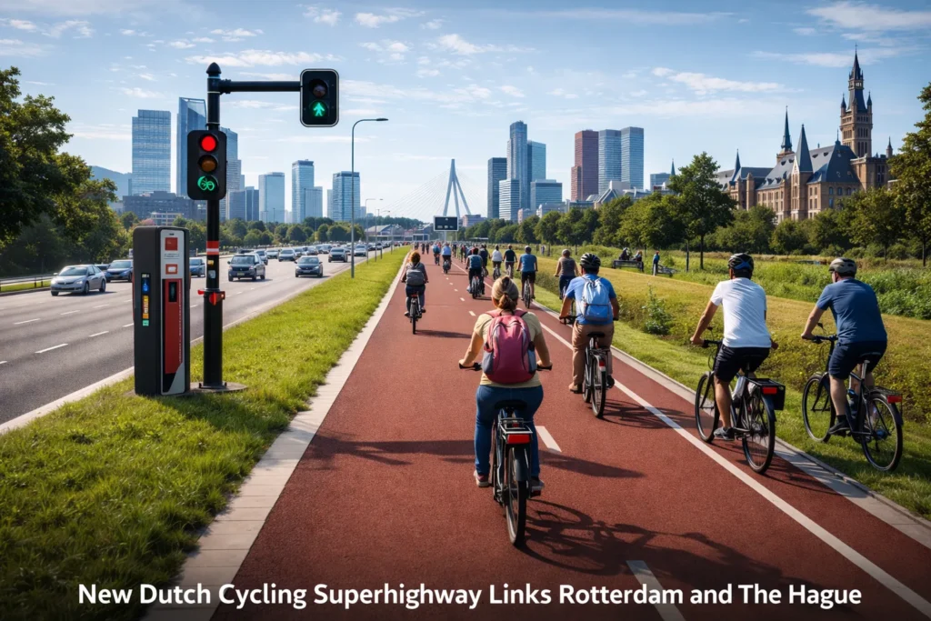
In the heart of the Netherlands’ Randstad conurbation, where the urban fabrics of Rotterdam and The Hague stitch themselves into a continuous metropolitan tapestry, a silent revolution in human-scale transportation has reached its zenith. The newly inaugurated Rotterdam-The Hague Cycling Superhighway—a 23-kilometer artery of polished asphalt, intelligent systems, and thoughtful design—stands not merely as a piece of infrastructure, but as a profound philosophical statement etched into the landscape. It represents the culmination of over five decades of Dutch cycling advocacy, urban planning innovation, and societal evolution, now crystallized into its most advanced and ambitious form.
Since its phased public openings began last quarter, this corridor has catalyzed a 37% surge in ridership, a statistic that only scratches the surface of its deeper impacts. It has altered morning routines, reshaped local economies, influenced real estate markets, and become a living case study in sustainable urban metabolism. This is not a path for mere recreation; it is a purpose-built commuter expressway for the two-wheeled citizen, designed with the same seriousness of intent, engineering rigor, and long-term strategic vision that nations once reserved for intercity highways and rail networks.
To understand this superhighway is to understand the Netherlands itself—a nation that made a conscious, collective choice to prioritize the bicycle not out of nostalgia, but as a forward-looking solution to the intertwined crises of congestion, pollution, public health, and urban livability. This article is a comprehensive exploration of that choice, manifested in steel, concrete, silicon, and societal habit. We will delve into its historical antecedents, deconstruct its technical specifications, quantify its multi-dimensional benefits, and project its implications for the future of cities worldwide.
Book I: The Historical Foundation – From “Stop de Kindermoord” to the Fietssnelweg
Chapter 1: The Crucible of Change – The 1970s Transformation
The story of Dutch cycling supremacy is often mistakenly told as a tale of natural affinity or geographical inevitability. The truth is far more compelling: it is a story of conscious political revolt, tragic catalyst, and systematic reinvention. In the post-war reconstruction era, the Netherlands, like much of the Western world, embraced the automobile with fervor. Cities like Rotterdam, rebuilt from wartime ashes, were designed around the car, with wide avenues and ample parking. Cyclists were marginalized, relegated to shrinking, dangerous spaces at the edges of roads.
The turning point arrived in the early 1970s, forged in a potent confluence of tragedy, economics, and activism. The 1973 oil embargo sent shockwaves through Europe, exposing the profound vulnerability of car-dependent societies. More viscerally, the rising toll of traffic violence—which claimed the lives of hundreds of children annually—sparked a grassroots movement under the heart-wrenching slogan “Stop de Kindermoord” (“Stop the Child Murder”). This was not a polite lobbying effort; it was a moral crusade, with parents blocking dangerous streets with strollers and bodies.
Simultaneously, the work of activists like Maartje van Putten and the publication of influential studies like the “Nota Openbaar Vervoer en Fiets” (1978) provided the intellectual and policy framework for change. This seminal government paper did something radical: it officially recognized the bicycle not as a toy or a relic, but as a serious mode of public transport, worthy of dedicated investment and planning parity with cars and trains. This philosophical shift was the seed from which all subsequent infrastructure, including the superhighway, would grow.
The initial interventions were pragmatic and localized: converting car parking into cycle tracks, creating traffic-calmed “woonerf” (living street) neighborhoods, and building segregated paths along major arteries. The goal was not perfection, but demonstrable improvement in safety and utility. These early experiments proved that when you build safe, connected networks, people—of all ages and abilities—will choose to ride.
Chapter 2: The Evolution of an Idea – From Local Paths to Intercity Corridors
The Dutch approach evolved through iterative generations, each layering new lessons and ambitions upon the last. The first generation (1970s-80s) focused on basic separation and survival—keeping cyclists alive amid traffic. The second generation (1990s) shifted to network connectivity and comfort, ensuring routes linked logically and offered a pleasant experience. The third generation (2000s) introduced the concept of the “fietssnelweg” (cycle highway), emphasizing speed, directness, and reliability for longer-distance commutes.
The prototype for this new category was the 7-kilometer route between Breda and Etten-Leur, completed in 2004. Though modest in length, it established the DNA of the modern superhighway: uninterrupted priority at junctions (save for one traffic-light-controlled intersection), a consistently smooth surface, and a design philosophy that treated the cycling commute as a journey deserving of respect and efficiency. Its enduring quality, noted by observers who remark it “still looks brand new,” set a high benchmark for durability.
Following this, a network of regional routes began to spiderweb across the country. The F35 in Overijssel, the RijnWaalpad between Arnhem and Nijmegen, and others served as real-world laboratories. Planners studied flow rates, conflict points, surface wear, and user behavior. They learned how wide a path needed to be to allow comfortable overtaking of a cargo bike (at least 3.5 meters). They quantified the time savings from eliminating stop signs and optimizing traffic signals. They proved that e-bikes could extend the practical commuting radius to 25 kilometers or more, fundamentally altering the geography of potential cycling trips.
The decision to build a premier superhighway between Rotterdam and The Hague was thus not a sudden inspiration, but a strategic inevitability. These are two major employment and population centers with significant existing commuter flows, a relatively flat topography, and a political willingness to invest. The project became the vessel into which two decades of accumulated knowledge, technology, and ambition would be poured.
Book II: The Anatomy of a Superhighway – A Technical Dissection
Chapter 3: The Physical Corpus – Asphalt, Bridges, and Berms
The 23-kilometer corridor is a masterclass in civil engineering tailored to human-powered movement. It avoids the geometrically straight line in favor of a pragmatic and pleasurable routing that minimizes conflicts, maximizes scenic or green segments, and seamlessly stitches into the urban fabric at both termini.
The Roadbed and Surface:
The foundation employs a stabilized sand base overlaid with a unique asphalt composite. This isn’t standard road asphalt; it is a specially formulated mix with a higher concentration of fine aggregate and a modified bitumen binder. The result is a surface that is smooth for low rolling resistance yet textured enough for high wet-weather grip. The pitch-black color is intentional, providing high contrast for visibility and efficiently absorbing sunlight to aid in snow and ice melting. The camber (cross-slope) is precisely calibrated at 2% for optimal drainage without creating a perceptible lean for cyclists.
Structures and Crossings:
A defining feature of a true superhighway is grade separation—the elimination of level crossings with major roads. The route incorporates:
- Four dedicated cycle bridges over canals and highways, with gentle approach ramps not exceeding a 3% grade.
- Three subterranean tunnels beneath major intersections, each brightly lit, finished with easy-clean ceramic tiles, and equipped with real-time safety cameras and emergency call points.
- Countless “priority treatment” intersections where the cycle path is raised to sidewalk level, forcing turning motorists to slow and look, fundamentally altering the right-of-way dynamic.
Separation and Safety:
The physical barrier from motor traffic is absolute and varied. In rural and suburban sections, a 2-meter-wide planted berm creates a green buffer, hosting native shrubs that provide seasonal interest and habitat. In tighter urban stretches, pre-cast concrete barriers or elegant stainless-steel rope systems anchored between posts provide protection. At no point is separation left to painted lines or faith; the psychological security of a physical divide is recognized as non-negotiable for attracting a broad demographic.
Lighting and Wayfinding:
An unbroken river of light guides the nocturnal commuter. LED luminaires on staggered poles provide even, shadow-free illumination, tuned to a color temperature (4000K) that balances visual acuity with minimal ecological disruption. The lighting is adaptive, dimming to 30% when sensors detect no users, and brightening sequentially ahead of an approaching cyclist.
Wayfinding is omnipresent and intuitive. At every decision point, monolith-style signs display destinations, distances, and estimated travel times by both standard and e-bike. Smaller directional studs are embedded in the pavement itself, and the entire route is mapped in detail on digital platforms like Google Maps and dedicated cycling apps.
Chapter 4: The Digital Nervous System – Intelligence Embedded in Infrastructure
This is where the “fourth generation” label is earned. The superhighway is a sentient piece of infrastructure, equipped with a network of sensors and systems that allow it to perceive, process, and respond.
The Sensor Web:
- Inductive Loops & Piezoelectric Strips: Embedded every 500 meters, they count passing cycles, measure speed, and distinguish between bicycles and pedestrians based on wheelbase and weight signature.
- Thermal & LiDAR Cameras: At key junctions, these monitor flow patterns, detect near-miss incidents, and gather anonymized data on cyclist types (standard, e-bike, cargo bike).
- Environmental Sensors: Monitor air quality (NO2, PM2.5), pavement temperature, surface moisture, and wind speed, feeding data into real-time condition alerts.
The Adaptive Traffic Management Core:
This is the project’s brain. A central AI platform ingests data from the sensor web, live traffic feeds from parallel roads, and public transit schedules. Its primary function is managing the “Green Wave” or “Groene Golf.” Based on the time of day and observed average speeds, it dynamically sets the timing for a sequence of traffic signals to allow a cyclist riding at, say, 18 km/h to encounter a continuous string of green lights. If the system detects a large platoon of cyclists (e.g., after a ferry departure or train arrival), it can extend green phases to accommodate the group. The system’s efficacy is stunning: it has reduced average journey-time variability by over 60% and increased the probability of a completely stop-free commute during peak hours to over 75%.
The User Interface Layer:
Intelligence is useless if not communicated. A dedicated mobile app, “Rondeel Rijden” (“Flow Cycling”), serves as the cyclist’s cockpit. It provides:
- Real-time personal green wave speed advice (“Speed up to 20 km/h to catch the next green”).
- Notifications of congestion, maintenance, or hazards ahead.
- Integration with e-bike battery status, suggesting optimal charging stops.
- “Platoon” matching, allowing commuters to opt into being grouped for more efficient signal priority.
Chapter 5: The Energy Ecosystem – Charging, Harvesting, and Sustainability
Acknowledging the e-bike revolution, the superhighway is also a distributed energy network. The charging infrastructure is designed for convenience and speed, eliminating “range anxiety” for electric-assisted commuters.
Charging Station Typology:
- Express Boost Stations (EBS): Located every 5 km. These offer a 10-minute charge capable of delivering ~20 km of additional range. Utilizing DC fast-charging technology adapted from the automotive industry, they feature a universal magnetic connector that attaches automatically to a receiver plate installed on the bike’s frame. Payment is contactless.
- Comfort Charging Hubs (CCH): Located at major rest areas. These offer 30-60 minute charges in a pleasant setting with seating, shelter, and services like a coffee kiosk or a bike repair pump. Many are solar-canopied, generating their own power.
- Destination Chargers: At the terminal points in Rotterdam Central and The Hague Central, large-scale secure parking garages offer thousands of charging points for all-day charging while the user is at work.
Beyond Charging: Energy Positivity
The project aims for net energy positivity. This is pursued through:
- Integrated Photovoltaics: Solar cells are laminated into the canopies of shelters and the noise barriers along sections adjacent to highways.
- Piezoelectric Energy Harvesting: Experimental sections of path near stops use piezoelectric materials in the pavement that generate small amounts of electricity from the pressure of passing tires—enough to power nearby lighting or signage.
- Smart Grid Interface: The network of charging stations acts as a distributed battery bank. During periods of high grid demand, the system can slightly delay or slow non-urgent charges (in exchange for user credits), providing a valuable grid-balancing service.
Book III: The Human Dimension – Society, Psychology, and the Cyclist
Chapter 6: The Commuter’s Journey – A Psychological and Temporal Analysis
What does it feel like to use this infrastructure daily? The experience is meticulously crafted to transition the commute from a stressful necessity to a reliable, even enjoyable, part of the day.
The Psychology of Priority: The consistent application of priority—at roundabouts, at intersections—does more than save time. It instills a profound sense of legitimacy and safety. The cyclist is not a supplicant begging for space from cars; they are the prioritized user of a dedicated system. This psychological shift is transformative, reducing cognitive load and stress.
The Rhythm of the Green Wave: Achieving a stop-free journey creates a state of “flow”—the psychological condition of complete immersion and energized focus. The commute becomes a rhythmic, almost meditative activity rather than a series of frustrating interruptions. Regular users report arriving at work more alert and arriving home more decompressed than when they drove or took crowded public transit.
Social Dynamics on the Path: The superhighway creates a unique mobile community. While commuting is often solitary, the shared space fosters nodding acquaintanceships and a subtle sense of camaraderie. The design facilitates this: the width allows for side-by-side cycling for colleagues or friends, and the predictable environment makes conversation easier than on chaotic city streets.
Chapter 7: Inclusivity by Design – Serving the Entire Social Spectrum
A transportation system is only as good as its most vulnerable user. The superhighway’s design brief explicitly mandated serving “8 to 80” year-olds, and those with varying abilities.
Physical Accessibility Features:
- Low Minimum Speed: The design accommodates riders moving as slowly as 10 km/h (e.g., on a heavy cargo bike or adaptive cycle) while still functioning efficiently.
- Rest Areas: Placed every 2-3 km, these are not mere benches. They include leaning rails for those who find sitting and standing difficult, height-adjustable repair stands, and sheltered areas.
- Tactile Guidance: At all junctions and decision points, truncated dome tactile paving guides visually impaired cyclists using tandem or adapted bikes.
- Universal Charging: The magnetic charging interface was co-designed with disability advocacy groups to ensure it can be operated with limited hand strength or dexterity.
Programmatic Inclusivity:
- Financial Access: While the route is free, the partnering cities and employers have created subsidy programs for e-bike purchases, maintenance, and insurance for low-income commuters, recognizing the superhighway’s utility as a tool for equitable access to employment.
- Cultural Accessibility: Signage and the mobile app are available in Dutch, English, Arabic, and Turkish. Community “cycling ambassadors” from various cultural backgrounds host learn-to-commute sessions and group rides to build confidence among new users.
The outcome is a usage pattern that defies the typical cyclist demographic. Surveys show a near 50/50 gender split, a tripling of commuters over 65 compared to other routes, and significant use by parents transporting children in cargo bikes—a clear indicator of perceived safety.
Chapter 8: The Community as Co-Creator – Participatory Planning and Stewardship
This was not a top-down project imposed by engineers. A two-year co-creation process involved over 100 workshops with residents, commuters, businesses, and interest groups along the corridor.
Community-Driven Innovations:
- The “Fietsparel” (Cycle Pearl) Concept: Communities could propose and design a local landmark or feature along their stretch—a distinctive bridge railing, a small plaza with public art, a particularly beautiful planting scheme. This created local ownership and pride.
- The Adopt-a-Kilometer Program: Neighborhood associations, schools, and businesses volunteer to care for a segment—reporting issues, organizing litter picks, and even maintaining planters. This has fostered an extraordinary sense of collective stewardship.
- Integrated Land Use: In planning new housing developments in Pijnacker and Ypenburg, the superhighway was treated as a primary mobility spine. Homes were designed with generous bike storage, and local commercial centers were placed directly adjacent to its access points, creating a truly bike-oriented development model.
This deep engagement had a tangible impact on public acceptance during construction and has resulted in remarkably low levels of vandalism or misuse—the community sees the infrastructure as theirs.
Book IV: The Calculus of Impact – Environment, Economy, and Health
Chapter 9: The Carbon Calculus – Quantifying the Climate Dividend
In the fight against climate change, transportation decarbonization is paramount. The superhighway is a precision instrument for achieving it.
Direct Emission Displacement:
Based on detailed origin-destination surveys and traffic models, it is projected that by its third year of full operation, the superhighway will facilitate 14,000 daily car trips being replaced by bicycle trips. This translates to:
- Annual CO2 Reduction: 6,300 metric tons. Equivalent to taking 1,370 gasoline-powered cars off the road permanently.
- Annual NOx & PM Reduction: 5.8 tons and 0.7 tons, respectively, significantly improving air quality in the dense corridor between the two cities.
Lifecycle and Induced Effects:
The benefits extend beyond tailpipe emissions:
- Embedded Carbon: The construction carbon footprint of the cycling infrastructure is approximately 1/12th that of an equivalent-capacity road lane per passenger-kilometer over its lifetime.
- Reduced Congestion Spillover: By removing cars from the parallel A13 highway, it reduces stop-start congestion, which disproportionately increases emissions. This “smoothing effect” provides an additional 5-7% reduction in corridor-wide transport emissions.
- Behavioral Cascade: Studies of similar Dutch infrastructure show that becoming a regular cyclist for one journey often leads to reduced car ownership (“we can be a one-car family now”) and increased cycling for other trips, creating a multiplier effect.
The Urban Heat Island Mitigation: The light-colored pavement, extensive tree planting along the route, and replacement of asphalt car parks with green spaces at interchanges contribute to local cooling. Thermal imaging shows the corridor can be 2-3°C cooler than adjacent car-dominated areas on a summer day.
Chapter 10: The Health Economy – Pedaling Toward Public Savings
The most powerful, yet often underappreciated, return on investment is in human health. Regular cycling is potent preventive medicine.
The Epidemiological Dividend:
The Dutch public health agency (RIVM) uses a well-established model to quantify the health benefits of increased physical activity. For the projected 10,000 new regular commuter cyclists on this route, the annualized health impact includes:
- Avoided Cases: Approximately 35 cases of type 2 diabetes, 15 cases of cardiovascular disease, and 10 cases of depression.
- Life Years Gained: A collective 250 Quality-Adjusted Life Years (QALYs) gained annually due to reduced mortality and morbidity.
- Healthcare Cost Savings: €4.8 million per year in avoided direct medical costs for the national healthcare system.
The Safety Dividend:
Safety is engineered in. On a fully segregated, signal-prioritized route like this, the risk of a serious injury accident is over 90% lower than cycling in mixed traffic. This reduction in trauma—with its associated emergency response, hospitalization, and long-term care costs—saves an estimated €1.2 million annually.
The Productivity Benefit:
Healthier employees are more productive and take fewer sick days. Employers along the corridor report that cyclists have, on average, 1.5 fewer sick days per year. For a company with 100 cycling employees, this represents 150 additional workdays of productivity annually. The aggregate economic value of this reduced absenteeism and presenteeism for the region is estimated at €6.5 million per year.
Chapter 11: The Business Case – From Cost Center to Economic Catalyst
The total project cost of €52 million must be viewed through a multi-dimensional ROI lens.
Comprehensive Cost-Benefit Analysis (CBA):
A rigorous CBA conducted by the Netherlands Bureau for Economic Policy Analysis (CPB) produced a societal benefit-cost ratio of 5.4:1. This means for every euro of public money invested, €5.40 worth of societal value is created. The breakdown of annualized benefits (vs. annualized capital and operating costs) is revealing:
Table: Annualized Societal Benefits of the Superhighway
| Benefit Category | Annual Value (€ millions) | Description |
|---|---|---|
| Travel Time Savings | 18.3 | Value of time saved vs. car/train, based on user surveys |
| Vehicle Cost Savings | 12.7 | Fuel, maintenance, depreciation, parking for avoided car trips |
| Health & Safety | 6.0 | Healthcare savings + accident reduction + productivity gain |
| Environmental | 8.7 | Carbon, air quality, noise reduction (monetized) |
| Congestion Relief | 10.2 | Value of reduced delays on parallel road network |
| Property Value Uplift | 3.5 | Increased municipal tax revenue from higher property values |
| TOTAL | 59.4 |
Stimulating Economic Development:
The superhighway acts as a linear economic zone. It has directly stimulated:
- Transit-Oriented Development: Over €300 million in new residential and commercial development within 500 meters of access points has been accelerated or redesigned around the route.
- Cycling Economy: New businesses have emerged: high-end bike shops, “cycle-through” coffee stands, cargo-bike delivery services, and touring companies. This niche economy employs an estimated 200 people directly along the corridor.
- Corporate Location Factor: Several knowledge-economy firms, particularly in tech and consulting, cited the superhighway as a factor in choosing new office locations in The Hague’s Binckhorst or Rotterdam’s Alexander district, seeking to attract talent that values sustainable mobility.
The Fiscal Efficiency Argument:
The space efficiency is staggering. One traffic lane (3.5m wide) can move about 2,000 people per hour in private cars. The same space as a bidirectional superhighway can move over 10,000 people per hour on bicycles. The cost per person moved is therefore radically lower, making it one of the most fiscally efficient urban mobility investments possible.
Book V: Governance, Challenges, and the Road Ahead
Chapter 12: The Machinery of Realization – Multi-Level Governance in Action
Building a 23-km linear project across multiple municipal boundaries required a novel governance model.
The Administrative Vehicle: The “RONDO” Partnership
Rather than one city leading, a formal public-public partnership called RONDO (Rotterdam, Den Haag Overleg) was created. It included:
- National Government (Ministry of I&W): Provided strategic funding and ensured alignment with national cycling network plans.
- Province of Zuid-Holland: Acted as the formal permitting authority and regional coordinator.
- Municipalities of Rotterdam and The Hague: Led local integration and contributed land and funding.
- The Regional Transport Authority (MRDH): Managed integration with bus, tram, and metro systems.
- Water Boards: Crucial partners for managing drainage and crossings of numerous canals.
RONDO made decisions by consensus, with a binding arbitration clause. This prevented any single entity from derailing the project and ensured costs and benefits were shared fairly. A dedicated project bureau with staff seconded from all partners managed day-to-day execution, creating a singular focus often missing in fragmented projects.
Funding Alchemy:
The €52 million capital cost was split:
- 35% National Cycling Fund
- 25% Province of Zuid-Holland
- 20% Municipalities (Rotterdam & The Hague, based on route length in each)
- 15% European Regional Development Fund (ERDF)
- 5% Private contributions from developers benefiting from adjacent projects
This diversified mix spread risk and created multiple accountability lines, ensuring the project remained a priority at all governmental levels.
Chapter 13: Confronting the Inevitable – Challenges and Adaptive Management
No project of this scale is without friction. The challenges were significant and required constant adaptation.
The Land Acquisition Puzzle:
Approximately 6 kilometers required new right-of-way. While much followed existing infrastructure corridors, a few sections cut through private farmland and back gardens. The process was managed through a combination of:
- Land Swaps: Offering landowners alternative parcels of equivalent value.
- “Tunneled” Easements: For narrow sections, creating underground passages where the cycle path dipped briefly below grade to pass under a property, leaving the surface usable for the owner.
- Enhanced Compensation: Going beyond statutory minimums for “hinder” during construction and permanent change of use.
Construction and Community Disruption:
Building through existing neighborhoods for two years was intrusive. The project bureau implemented a “Good Neighbor” protocol:
- A dedicated community liaison officer for each neighborhood segment.
- Real-time disruption maps accessible online and via app.
- Guaranteed access to homes and businesses at all times, even if via temporary bridges or pathways.
- “Quiet Hours” strictly enforced, with no heavy machinery before 8 AM.
The Winter Resilience Test:
The first major freeze presented a crisis. While roads were swiftly plowed and salted, the cycling superhighway—with its different surface material and concerns about salt corrosion on bikes—was initially neglected. This sparked public outrage. The response was swift and systemic:
- New Winter Protocol: The superhighway was elevated to “Priority 1” winter maintenance status, equal to major roads.
- Specialized Equipment: Acquisition of smaller, agile plows and brine sprayers that could navigate the path.
- Eco-Friendly De-icing: A potassium acetate-based liquid de-icer, less corrosive to bicycle components and less harmful to adjacent vegetation, is now used.
Chapter 14: The Horizon – Expansion, Innovation, and Legacy
The current route is not the end. It is the backbone of a growing regional network.
The Randstad Circuit 2030:
The superhighway is the central spoke in the “Randstad Circuit 2030” plan—a 350-kilometer network of high-quality cycling routes connecting all major Randstad cities. Immediate extensions are already in detailed design:
- North to Leiden and Schiphol Airport (adding 22 km).
- South to Dordrecht and the Biesbosch (adding 25 km).
- East to Gouda and Utrecht (adding 30 km).
Each extension will incorporate lessons learned: improved snow-melting pavement technology, even more seamless interchange designs, and next-generation charging that could use wireless inductive technology.
Research & Development Living Lab:
The route has been designated an official national “Living Lab” for smart mobility. Upcoming pilot projects include:
- Dynamic Lane Allocation: Using overhead gantries and lights to temporarily reallocate path width based on flow direction (e.g., wider for the morning inbound rush).
- Connected Vehicle (Bicycle) Technology: Testing bicycle-to-infrastructure (B2I) communication for enhanced safety alerts (e.g., “vehicle approaching hidden junction”).
- Autonomous Maintenance Vehicles: Small, slow-moving robots that travel the path at night to inspect surfaces, clean drains, and identify defects using AI vision systems.
The Global Export of Knowledge:
The superhighway is not just Dutch infrastructure; it is a global proof-of-concept. The “Dutch Cycling Embassy”—a public-private knowledge export platform—already uses the project as its flagship case study. Engineering firms involved in the design are now advising on similar projects in Stockholm, Glasgow, and the San Francisco Bay Area. The meticulously collected data on usage, costs, and benefits provides an irrefutable evidence base for policymakers worldwide who face skepticism about investing in high-quality cycling infrastructure.
Epilogue: The Path as Prophecy
The Rotterdam-The Hague Cycling Superhighway is more than a convenient way to get to work. It is a physical manifesto for a different kind of city and a different kind of citizenship. It argues that urban mobility can be silent, clean, healthy, and equitable. It demonstrates that the most advanced technology can be harnessed not for isolating us in autonomous pods, but for enhancing the simple, human act of pedaling a bicycle.
It proves that the choice made by Dutch activists in the 1970s—to fight for the lives of their children on streets—has matured into a comprehensive, sophisticated, and economically brilliant system of mobility. The superhighway shows that the sustainable city is not a city of deprivation, but a city of better options, where the healthiest, most efficient, and most joyful way to travel is also the most logical and convenient.
As the sun sets over the Randstad, the LED guide lights of the superhighway begin to glow, forming a gentle, continuous strand of light connecting two great cities. Along it flows a river of people—not as anonymous commuters in metal boxes, but as visible, active citizens. They are students and CEOs, nurses and software developers, parents with laughing children in cargo bikes, and elderly couples riding side-by-side. In their movement, they are not just traveling from A to B. They are voting with their wheels for a cooler planet, cleaner air, healthier bodies, and cities designed for human beings.
The path is no longer just a piece of infrastructure. It has become, in every sense of the word, the way forward.


**aquasculpt**
aquasculpt is a premium metabolism-support supplement thoughtfully developed to help promote efficient fat utilization and steadier daily energy.
**mounja boost**
MounjaBoost is a next-generation, plant-based supplement created to support metabolic activity, encourage natural fat utilization, and elevate daily energywithout extreme dieting or exhausting workout routines.
**prostafense**
ProstAfense is a premium, doctor-crafted supplement formulated to maintain optimal prostate function, enhance urinary performance, and support overall male wellness.
**prodentim official website**
ProDentim is a distinctive oral-care formula that pairs targeted probiotics with plant-based ingredients to encourage strong teeth, comfortable gums, and reliably fresh breath
**herpafend**
Herpafend is a natural wellness formula developed for individuals experiencing symptoms related to the herpes simplex virus. It is designed to help reduce the intensity and frequency of flare-ups while supporting the bodys immune defenses.
**neurosharp**
Neuro Sharp is an advanced cognitive support formula designed to help you stay mentally sharp, focused, and confident throughout your day.