A Comprehensive Guide to the New Rules Transforming High-Altitude Mountaineering
Part One: The Awakening
Chapter 1: The Ghosts on the Mountain
The wind was screaming. Not the kind of wind that rattles your windows at home or sends leaves skittering across your lawn, but the kind of wind that picks up frozen ice pellets and shoots them at you like a million tiny needles. It was the kind of wind that steals your breath the moment you open your mouth, that freezes your eyelashes together until you can’t blink, that makes the world disappear into a swirling, endless white void where up and down lose all meaning.
High on the slopes of an 8,000-meter peak in the Himalayas, a climber we’ll call Marco was in serious trouble. He had been climbing with a guide, part of a commercial expedition trying to reach the summit of one of the world’s tallest mountains. The morning had started promisingly enough—clear skies, moderate winds, the kind of day that makes climbers feel like the mountain might actually let them succeed. But in the mountains, weather changes faster than anywhere else on Earth. By mid-afternoon, the clouds had rolled in, and by late afternoon, a full whiteout had descended.
A whiteout is one of the most dangerous situations a climber can face. It’s not just fog or clouds—it’s a phenomenon where the sky, the snow, and the ground all blend into one blinding, disorienting wall of white. You cannot see your hand in front of your face. You cannot tell up from down. Your inner ear, which helps you keep your balance, goes haywire because it gets conflicting signals from your eyes and your body. Climbers have been known to walk off cliffs in whiteouts, or walk in circles until they collapse from exhaustion, because their brains simply cannot process where they are or where they’re going.
Marco became separated from his guide in that whiteout. One moment, he could see the dark shape of his guide just a few feet ahead, a ghostly figure moving through the mist. The next moment, the guide vanished into the whiteness as if he had never existed. Marco called out, but the wind ripped his voice away before it could travel more than a few feet. He stumbled forward, trying to find the trail, trying to find anyone, but every step took him further from safety and deeper into the white void.
For hours, Marco wandered. He had no idea if he was going up or down, toward camp or away from it. His oxygen was running low. The cold was seeping through his layers. His mind, deprived of oxygen and exhausted from the effort, was starting to play tricks on him. He saw shapes that weren’t there, heard voices in the wind. He was, by any reasonable measure, dying.
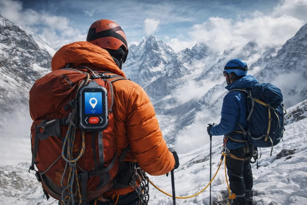
But Marco had one thing that climbers of previous generations didn’t have. Strapped to his harness, in a pocket designed for easy access, was a small brick-shaped device about the size of a deck of cards. It was heavy for its size, filled with electronics and a powerful battery. On its face was a covered button, bright red and impossible to miss.
With frozen fingers that felt like clubs at the ends of his arms, Marco fumbled for the device. He found it, pulled it out, and with the last of his strength, opened the protective cover and pushed the button.
He didn’t know if it would work. He didn’t know if anyone would hear. But it was the only thing he could do.
Nearly 2,000 miles away, in a rescue coordination center in Kathmandu, Nepal, a screen lit up. An alarm sounded—not a loud, scary alarm that would panic everyone in the room, but a soft, insistent chime that got the attention of the person on duty. A blinking dot appeared on a digital map of the Himalayas. Next to the dot, coordinates appeared. Next to the coordinates, a name appeared: Marco. And next to the name, an ID number linked to his expedition and his emergency contacts.
Within minutes, the rescue coordinator was on the phone with Marco’s expedition base camp. Within an hour, a helicopter rescue operation was being planned. They knew exactly where Marco was. They knew his last known direction of travel. They knew how long he had been stationary. All from that single button push.
Ten years ago, Marco’s story might have ended very differently. He might have wandered for hours, eventually collapsing from exhaustion and cold. His body might have been found years later, if ever, by another climbing team. He would have become one of the ghosts of the mountain—one of the estimated 200 to 300 climbers whose bodies remain on Everest alone, frozen in time, serving as grim landmarks for those who follow.
But Marco survived. He was rescued by a helicopter that flew directly to his coordinates, plucking him from a ridge where he had finally stopped wandering and huddled against a rock for shelter. He spent three days in a hospital in Kathmandu recovering from frostbite and exhaustion, and then he flew home to his family.
His survival is a direct result of one of the most significant rule changes in the history of modern mountaineering: the mandatory requirement for GPS-based emergency tracking devices on the world’s highest peaks.
This isn’t just a story about a piece of technology. It’s not just a story about new rules and regulations. It’s a story about people—about climbers chasing dreams, about guides risking their lives to save others, about families waiting anxiously at home, and about the hard, practical lessons learned from tragedy. It’s about balancing the wild, free spirit of adventure with the responsibility to come home alive.
To understand why this rule exists and why it matters, we have to go back to the beginning. We have to understand the problem that these authorities were trying to solve.
For decades, climbing a giant like Everest or K2 was like playing a deadly game of hide-and-seek—except the person hiding didn’t want to be found, and the people seeking were racing against time in the most dangerous environment on Earth.
When something went wrong on a high mountain—a sudden storm, a fall into a crevasse, a case of severe altitude sickness, a stroke or heart attack caused by the extreme conditions—the climber in trouble became a needle in a very large, very dangerous haystack. And that haystack was the size of a mountain.
Imagine trying to find a lost person on a mountain the size of Everest. It’s not just big; it’s incomprehensibly vast. Mount Everest stands 29,032 feet above sea level. But its size isn’t just vertical. The mountain and its surrounding peaks cover hundreds of square miles of rugged, icy terrain. It’s a three-dimensional maze of ice cliffs, hidden crevasses that can be hundreds of feet deep, vast sloping faces of rock and ice, and ridges that stretch for miles at altitudes where the air is too thin to breathe.
In the past, when a climber went missing, rescue teams faced an almost impossible task. They would have to rely on a last-known location reported by a fellow climber or guide, which could be hours old by the time a rescue could be organized. They would scan the slopes with binoculars and telescopes from base camp, hoping to spot a colored jacket or a waving arm. They would send out small search parties to climb to the last known location and look around, but those search parties were also at risk. They were exhausting themselves at high altitude, using up precious oxygen, and exposing themselves to the same dangers that had taken the missing climber.
It was slow. It was inefficient. And it was incredibly risky for the rescuers themselves.
This system, if you could call it a system, led to too many tragedies. Climbers would get into trouble, and by the time a search could be properly organized, they had vanished into the vastness of the mountain. They became part of the landscape. Their stories remained untold. Their final hours remained a mystery to everyone except the mountain itself.
These ghosts—the climbers who were never found, or whose bodies were discovered years later by accident—served as a grim reminder of how quickly a dream can turn into a disaster. On Everest alone, it’s estimated that around 200 bodies remain on the mountain. Some are in places where they can be seen by passing climbers, earning nicknames like Green Boots, a famous landmark on the Northeast route who has guided countless climbers on their way to the summit, though no one knows his real name or his story. Others are hidden in crevasses, buried by avalanches, or lying in remote areas that no one visits.
The authorities—including the governments of Nepal and Pakistan, mountaineering associations, and rescue organizations—didn’t make this rule lightly. They didn’t wake up one day and decide to add more bureaucracy to an already permit-heavy process. They looked at the data. They studied the patterns. They analyzed the tragedies.
What they saw was concerning. The number of climbers attempting high peaks was going up every year. In recent seasons, Nepal has issued record numbers of climbing permits for Everest. More people meant more potential for accidents. But the success rate of rescues wasn’t keeping pace with the increasing number of climbers.
The main problem, they realized, wasn’t the rescuing part—it was the finding part. Once a rescue team could locate a climber, they were usually able to mount an effective rescue. But finding the climber in the first place was taking too long. Hours, sometimes days, were wasted on search efforts. And in the mountains, hours can mean the difference between life and death.
They realized that if they could eliminate the search from search and rescue, they could save countless lives. If they could know exactly where a climber was the moment something went wrong, they could dispatch help immediately, directly to that location, without wasting precious time looking in the wrong places.
The tracker was the obvious answer. It wasn’t about controlling climbers or monitoring their every move. It wasn’t about limiting freedom or spoiling the adventure. It was about giving climbers a better chance to come home. It was about providing a lifeline that could be thrown across thousands of miles of ice and rock. It was about turning the ghosts of the mountain into survivors.
Chapter 2: A Deadly Season
Sometimes it takes a tragedy to force change. Sometimes it takes a series of tragedies. For the mountaineering authorities in Nepal, the wake-up call came during a particularly deadly climbing season—a year that would go down as one of the deadliest in the history of Everest climbing.
The numbers were stark and sobering. During that climbing season, there were multiple confirmed fatalities on the slopes of Mount Everest. But that wasn’t even the worst part. In addition to those deaths, several other climbers were declared missing. They simply vanished. They walked into the clouds or the snow or the darkness, and they never came back. Their families were left with no closure, no body to mourn, no final resting place to visit. They became ghosts.
That brought the total to a shocking number of people who either died or disappeared on a single mountain in a single season. For context, that’s more than the total number of climbers who died on Everest in the entire decade of the 1980s. It was a stark reminder that despite all the advances in gear, weather forecasting, and guiding, the mountain was still deadly.
But here’s the thing about those missing climbers: they might have been found if the rescuers had known where to look. If each of those climbers had been carrying a tracker, the search teams would have known their last known positions. They would have had a place to start looking. They might have found bodies to bring home to grieving families. They might even have found survivors.
That season wasn’t just deadly on Everest. Other peaks in Nepal also claimed lives. Annapurna, which has one of the highest fatality rates of any 8,000-meter peak, saw its share of tragedies. K2, across the border in Pakistan, also recorded deaths. But it was the sheer number of missing climbers on Everest that really got the attention of officials.
The government of Nepal realized they had a problem. They couldn’t control the weather. They couldn’t control the altitude. They couldn’t control the decisions climbers made when they were exhausted and oxygen-deprived. But they could control the tools that climbers carried. They could require a device that would eliminate the missing part of the equation.
In the following year, the announcement came: all climbers attempting to scale Mount Everest would be required to wear tracking devices. The satellite-linked chips would be rented from the government as part of the permit issuing process. They would be stitched into the mountaineer’s clothes and handed back after the descent.
The rule wasn’t just about Everest. It applied to all the high peaks in Nepal, which is home to eight of the world’s ten highest mountains. But Everest, as the most famous and most climbed of them all, became the symbol of this new approach to safety.
The timing made sense. The short Everest climbing season usually comes in the spring, when weather conditions are most favorable. The announcement came just ahead of the next season, giving climbers and expedition companies time to prepare. By the time the first teams started arriving at base camp, the trackers were ready and waiting.
Some climbers grumbled about the added cost and the extra gear. Some worried about privacy and being tracked. But most understood the logic. After one of the deadliest years in nearly a decade, something had to change. The trackers were that change.
Chapter 3: Voices from the Slopes
To really understand how trackers are being received in the climbing community, you have to talk to the people who are actually using them—the climbers themselves. Their opinions vary widely, but there are some common themes that emerge from conversations with those who have experienced the mountains both before and after the tracker requirement.
The Experienced Climber
Take Sarah, a British climber who has summitted Everest twice and is planning a third attempt. She remembers climbing before trackers were mandatory, when communication was limited to sporadic radio calls and handwritten notes left at camps. In those days, her family would go weeks without hearing from her, not knowing if she was safe or if something had gone wrong.
Honestly, I was skeptical at first, she admits. I’ve been climbing for twenty years, and I’ve always prided myself on being self-sufficient. The idea of having a tracker felt like admitting I couldn’t handle things on my own. It felt like cheating, somehow, like I was relying on technology instead of my own skills and judgment.
But after using a tracker on her last climb, her opinion changed. It wasn’t for me—it was for my family. My mum spent the whole climb following my progress on the tracking website. She could see when I reached each camp, when I was moving, when I was resting. She slept better knowing I was okay. And if something had gone wrong, she would have known immediately that help was on the way. That peace of mind is worth carrying a little extra weight.
Sarah acknowledges that the tracker changed her own experience as well. I found myself thinking less about what might go wrong, she says. In the past, there was always this nagging worry in the back of my mind—what if I fall, what if I get lost, what if no one finds me? With the tracker, that worry just isn’t there. I can focus on the climbing, on the mountain, on the experience. It’s liberating, in a way.
The First-Time Climber
Then there’s James, an American climber attempting Everest for the first time. For him, the tracker is a source of confidence, not a burden. He’s not a professional climber with decades of experience. He’s an ordinary person who saved for years to afford this dream, and he’s acutely aware of his limitations.
I’m not a professional climber, he explains. I’m a guy with a dream and enough savings to make it happen. I know my limitations. I know I’m not the strongest climber on the mountain. Having a tracker makes me feel like if I get into trouble, someone will find me. It’s like a safety net.
James acknowledges the criticism that trackers might encourage inexperienced climbers to take more risks. I can see that argument, he says. But for me, it’s the opposite. Knowing I have a tracker doesn’t make me more reckless—it makes me more confident. I’m still scared, still careful, still respectful of the mountain. But I’m not terrified. And that helps me make better decisions.
He pauses, considering his words. Fear can kill you up there, he continues. If you’re too scared, you make bad choices. You freeze up when you need to move. You panic when you need to think clearly. The tracker takes the edge off that fear. It lets me focus on the climb instead of the what-ifs.
The Skeptic
Not everyone is convinced. Marco, an Italian guide with decades of experience, still has reservations about mandatory trackers. He’s been climbing since before GPS was widely available, and he remembers a time when mountaineering was a purer pursuit.
The mountain should not become a theme park, he argues. When you require everyone to carry a tracker, you are saying that everyone deserves to be rescued, no matter what. But mountaineering has always included the possibility that you might not come back. That is part of what makes it meaningful.
Marco worries that trackers create a false sense of security. People think, I can push the button and someone will come. But rescues are not always possible. In bad weather, at night, in an avalanche—no tracker can fix that. The tracker is not a guarantee of survival.
He also worries about the impact on climbing culture. When I started guiding, climbers were self-reliant, he says. They carried their own gear, made their own decisions, accepted their own risks. Now, more and more, climbers rely on technology. They trust the device instead of trusting themselves. That is dangerous.
Despite his reservations, Marco carries a tracker on all his climbs. I follow the rules, he says with a shrug. And if one of my clients gets into trouble, I want to be able to find them. So I carry it. But I don’t have to like it.
The Family Member
Perhaps the most powerful perspective comes not from climbers but from their families. Maria, whose husband died on Everest before trackers were mandatory, wishes things had been different.
He went missing during a storm, she says quietly. They searched for three days and never found him. For months, I hoped he might walk out of the mountains, that he’d been taken in by another expedition and just couldn’t communicate. The not knowing was worse than anything.
If her husband had been carrying a tracker, she would at least have known where he was. She would have had closure. I think about that every day, she says. A little device could have given me that. It wouldn’t have brought him back, but it would have given me peace.
For Maria, the tracker debate isn’t philosophical. It’s deeply personal. And her story illustrates why so many climbers—and their families—have embraced the new technology. It’s not about the climbers themselves. It’s about the people who love them and wait for them at home.
Chapter 4: The Guide’s Perspective
To really understand the impact of these tracking devices, you have to talk to the people on the front lines every day: the guides and Sherpa who lead climbers up the world’s highest peaks. For them, trackers aren’t a philosophical debate or a theoretical concern. They’re a practical tool that changes how they do their jobs, how they manage their teams, and how they handle emergencies.
The Challenge of Keeping a Team Together
Imagine being a guide responsible for a team of five or six climbers on a mountain like Everest. You’re leading people from all over the world, with different fitness levels, different experience levels, different personalities, different motivations. They’re all dealing with the altitude, the cold, the exhaustion, the fear. And you’re trying to keep them together and moving in the right direction while also managing your own climb.
In the past, if someone fell behind or got lost in a storm, you faced a heartbreaking choice. Do you go back to look for them, risking the safety of the rest of your group? Do you send another guide back, reducing the support for the remaining climbers? Or do you push on, hoping they can find their own way down, hoping they’ll be okay?
None of those options were good. Each one involved risk and uncertainty. Each one could lead to tragedy. Guides carried the weight of those decisions for years afterward, second-guessing themselves, wondering if they could have done something different.
The Tracker Solution
Now, with trackers, that calculation has changed. Guides can issue a tracker to every member of their team. They can see on their own device exactly where everyone is, in real time. If one client is moving slowly, the guide knows. If a client has stopped moving altogether, the guide knows. If a client is heading off-route, the guide knows.
This information allows guides to make better decisions. They can call a client on the radio and say, You’re drifting left, come back to the right. They can send one guide back to help a struggling climber while the rest of the team continues safely. They can make the call to have a client turn back early based on their actual position and progress, not just a guess.
Pemba Sherpa, a veteran guide who has summitted Everest over ten times, explains it simply. Before trackers, my biggest worry was losing a member in the fog or a storm. You could be five feet away and not see someone. Now, I can see them on my device. I know exactly where everyone is. It is like having eyes in the back of my head.
He laughs at the image. I don’t actually have eyes in the back of my head, he says. But the tracker is the next best thing.
Managing Multiple Teams
For lead guides responsible for multiple teams, trackers are even more valuable. They can monitor all their guides and all their clients from base camp. They can see where bottlenecks are forming on the route. They can track the progress of each team and coordinate their movements to avoid crowding.
This big-picture view helps prevent the kind of traffic jams that have become a problem on popular peaks. When climbers are stuck waiting in line at high altitude, they burn through their oxygen supplies and increase their risk of frostbite and exhaustion. With trackers, guides can space out their teams, sending them at different times to avoid congestion.
It also helps with logistics. If a team is moving faster than expected, base camp can have supplies ready earlier. If a team is moving slower, base camp can adjust schedules and prepare for a later arrival. The tracker data feeds into every aspect of expedition planning.
Rescue Coordination
When something does go wrong, trackers make guides’ jobs easier and safer. If a client triggers an SOS, the guide knows immediately and can see exactly where they are. They can respond directly, without searching. They can coordinate with rescue services, providing accurate location data and updates on the situation.
This coordination is crucial in the chaos of an emergency. When every second counts, not having to search saves time. And saving time saves lives.
In one recent incident, a client on Pemba’s team fell into a crevasse. The fall was sudden and unexpected—one moment the client was walking along, the next moment the snow gave way and he was gone. In the past, the team would have had to carefully search for the crevasse, probe with poles, and hope they found the right spot before the client succumbed to cold or injury.
But this client was wearing a tracker. Pemba could see exactly where he had been when he fell. The team went straight to that spot, located the crevasse, and pulled the client out within thirty minutes. He survived with minor injuries.
Without the tracker, Pemba says, we might have searched for hours. He would have died.
The Emotional Toll
There’s also an emotional side to this that’s often overlooked. Guides carry a tremendous burden of responsibility. They feel personally accountable for the safety of their clients. In the past, when something went wrong, that burden was even heavier because of the uncertainty.
Pemba describes it this way. Before, if a client went missing, you would spend days searching, hoping, praying. You would blame yourself. You would wonder if you could have done something different. It was terrible.
Now, he says, if something happens, we know where they are. We can go straight to them. We can do everything possible to save them. And if we can’t save them, at least we know we did everything. At least we can bring them home to their families.
That peace of mind matters. Guides risk their lives every time they go up the mountain. They deserve tools that make their job safer and more effective. Trackers provide that.
Part Two: The Technology
Chapter 5: What Exactly Is a Mandatory Tracker?
Let’s clear up a common confusion right away, because this is where a lot of people get mixed up. When people hear GPS tracker, they often think of the map app on their smartphone. They imagine pulling out their phone, opening Google Maps or Apple Maps, and seeing a little blue dot that shows where they are. They imagine being able to share that location with friends or family, or using it to navigate through unfamiliar terrain.
But here’s the reality: a smartphone is completely useless at 26,000 feet. It’s not just useless—it’s worse than useless because it gives a false sense of security. Let me explain why.
First, the cold. At high altitude, temperatures can drop to forty degrees below zero Fahrenheit, which is also forty degrees below zero Celsius, the point where the two scales meet and the cold becomes truly indescribable. At those temperatures, a smartphone battery dies in minutes. The chemical reactions inside the battery slow down and eventually stop altogether. The screen freezes and becomes unresponsive. The delicate electronics inside the phone can’t handle the extreme cold—components contract, connections break, and the phone simply stops working.
Second, the lack of cell service. Smartphones rely on cell towers to communicate. Those towers are everywhere in cities and towns, but they don’t exist on the side of a mountain. There’s no 5G at 8,000 meters. There’s no 4G, no 3G, no signal at all. A smartphone becomes a brick—a very expensive, very fragile brick that does nothing but add weight to your pack.
Third, the power issue. Even if a smartphone could survive the cold and find a signal, which it can’t, its battery would be drained within hours by the constant searching for a network. Climbers on high mountains are out for weeks. They need devices that can last for days or weeks on a single charge, not hours.
The devices that are now mandatory on high peaks are a completely different breed of animal. They are rugged, purpose-built beacons designed for one main job: sending your exact location to the outside world, no matter where you are, no matter what the conditions.
Think of them as a cross between a heavy-duty walkie-talkie and a satellite phone, but designed specifically for emergencies. They don’t have fancy touchscreens or apps. They don’t play music or take photos. They do one thing, and they do it incredibly well.
These devices communicate directly with satellites orbiting hundreds of miles above the Earth. They don’t need cell towers. They don’t need Wi-Fi. They just need a clear view of the sky—and on a mountain, you usually have that, even in bad weather. The signals they send are powerful enough to punch through clouds and snow, reaching the satellites even in the worst conditions.
The devices are built to survive extreme conditions. They’re waterproof, meaning they can be submerged in water without damage. They’re shockproof, meaning they can be dropped on rocks without breaking. They’re designed to keep working even after being buried in snow or exposed to the worst weather the mountains can throw at them. Their batteries can last for days in active mode and weeks or even months in standby mode. Some use regular AA batteries that can be replaced in the field, which is useful for long expeditions. Others have rechargeable batteries that can be topped up at base camp between climbs using solar panels or generators.
When you press the SOS button on one of these devices, it sends out a powerful signal that doesn’t contain a message, just a coded ID and a location. That signal is picked up by a satellite and relayed to a ground station, which then alerts rescue authorities. Within minutes, someone somewhere in the world knows that you’re in trouble and exactly where you are.
That’s the tracker. That’s the device that’s now saving lives on the world’s highest mountains. It’s not a fancy gadget or a toy. It’s a serious piece of safety equipment that can mean the difference between life and death.
Chapter 6: PLBs Versus Satellite Messengers
When you start looking into tracking devices for mountaineering, you’ll quickly discover that there are two main types available. They do similar things, but they work in different ways and have different strengths. Understanding the difference is important because the right choice depends on what kind of climbing you’re doing and what you need from your device.
Personal Locator Beacons
PLBs are the no-nonsense, professional-grade devices. They’re the ones you see rescue services using, the ones that are registered to you like a car license plate, the ones that have exactly one job: saving your life in an emergency.
When you buy a PLB, you register it with the national authority in your country. In the United States, that’s NOAA, the National Oceanic and Atmospheric Administration. In Canada, it’s the Canadian Beacon Registry. In the United Kingdom, it’s the Maritime and Coastguard Agency. You provide your name, your address, your emergency contacts, and a description of the types of activities you do. That information is stored in a database that search and rescue authorities around the world can access.
When you activate a PLB in an emergency, it sends a unique signal to a network of government-owned search and rescue satellites called the COSPAS-SARSAT system. This is an international network that’s been operating since the 1980s and has helped rescue tens of thousands of people worldwide. The system includes satellites in low Earth orbit that constantly circle the globe, listening for distress signals, and geostationary satellites that hover over fixed points, providing continuous coverage of large areas.
The signal from a PLB goes straight to the authorities. There’s no middleman, no commercial service, no monthly fee. It’s a direct line to the people who can send help. The satellites pinpoint your location and alert the nearest rescue coordination center, which then dispatches the appropriate resources.
PLBs are incredibly reliable. They’re built to military specifications and tested extensively. They have powerful batteries that can transmit for twenty-four hours or more. They’re designed to work in the worst conditions imaginable—buried in snow, submerged in water, dropped from height, exposed to extreme temperatures.
The downside of PLBs is that they’re one-way devices. They send a signal, but they don’t receive anything. You don’t know if your signal was received. You can’t communicate with rescuers. And they’re for emergencies only—you can’t use them to send a quick message to your family or check the weather. They’re strictly for when things go seriously wrong.
Satellite Messengers
Satellite messengers are more common among recreational climbers and adventurers. They’re like a two-way satellite communication hub you can hold in your hand. They offer more features than PLBs, but they also require a subscription and are slightly less rugged.
The key feature of a satellite messenger is two-way communication. Most of them have an SOS button that works just like a PLB, alerting a twenty-four-hour professional response center staffed by real people who can coordinate rescues. But they also allow for texting. A climber can send a message to their family saying, Made it to Camp Two, feeling good, or Running a day late, but safe. They can receive weather forecasts and updates from base camp. They can communicate with guides and other team members.
This constant, low-stakes communication is a game-changer for logistics and family peace of mind. Imagine being the parent or spouse of someone climbing Everest. In the past, you might go weeks without any news, not knowing if they were safe or if something had gone wrong. Every day without news was a day of worry. With a satellite messenger, you can get regular updates. That I’m OK message means more than you can imagine.
Satellite messengers use commercial satellite networks like Iridium or Globalstar. The Iridium network consists of sixty-six cross-linked satellites in low Earth orbit, providing truly global coverage, including the poles. The Globalstar network also provides good coverage, though it’s not as complete as Iridium’s. These networks are designed for two-way communication, so they can handle not just emergency signals but also regular messages.
The devices themselves are smaller and lighter than they used to be, and battery life is good—typically several days of active use or weeks on standby. Modern messengers are pretty tough, though they’re not quite as rugged as PLBs. They can handle the conditions on most mountains, but they might not survive the absolute worst-case scenarios.
The downside of satellite messengers is that you have to pay for a subscription, which can be expensive. The devices themselves cost money, and the monthly plans add up. You might pay several hundred dollars a year for a basic plan, and more for advanced features like weather forecasting. And because they’re more complex, with more features and functions, there’s more that can go wrong.
Which One Is Better?
For high-altitude mountaineering, both types are acceptable and both meet the mandatory requirements in most places. Many climbers carry both—a PLB as a backup for absolute emergencies and a messenger for daily communication and coordination. This gives them redundancy, which is always good in the mountains, and the benefits of both systems.
But if you had to choose one, a satellite messenger with two-way communication is probably the better choice for most climbers. The ability to get weather updates, communicate with base camp, and send reassuring messages to family is valuable. And in an emergency, two-way communication with the response center can be crucial—you can tell them what’s wrong, what you need, and how to find you.
The important thing is that both types do the essential job: they tell rescuers exactly where you are when you need help. Whether you choose a PLB or a messenger, having one on your harness could save your life.
Chapter 7: How the Beacons Work in the Death Zone
The true magic of these tracking devices becomes most apparent in what climbers call the Death Zone. This is the area above approximately 26,000 feet, or 8,000 meters, where the air pressure is so low that your body cannot function normally. At these altitudes, there’s simply not enough oxygen in the atmosphere to sustain human life for more than a few days.
In the Death Zone, your body is literally dying, minute by minute. Your cells are starving for oxygen. Your brain doesn’t work right—you make poor decisions, you forget simple things, you become irrational. Your judgment is impaired in ways you don’t even recognize. You might take off your gloves without realizing it, leading to frostbite. You might wander off the trail without noticing. You might decide to keep climbing when you should turn back.
Moving is an agonizing effort that requires enormous willpower. Every step feels like you’re carrying a hundred-pound pack, even when you’re carrying nothing. Your muscles scream for oxygen they can’t get. Your lungs burn with every breath. Your heart races, trying to pump what little oxygen there is to your starving tissues.
In this state, a climber cannot give complex directions to rescuers. They might not be able to speak coherently on a radio. They might not even remember their own name or where they are. But they can push a button.
That’s the genius of the tracker. It requires no thought, no skill, no coherent communication. It’s a simple physical action that anyone can perform, even in the most extreme circumstances.
The trackers are designed to be operated with cold, clumsy fingers. The SOS button is usually protected by a cover that prevents accidental activation, but it’s easy to open even with gloves on. Once the cover is open, pressing the button requires just a small amount of force—nothing that would be difficult for a weakened climber.
When that button is pressed, the device springs into action. It immediately begins transmitting a signal that contains the device’s unique ID and its current GPS coordinates. It sends this signal repeatedly, ensuring that at least one transmission gets through even if conditions aren’t perfect.
The device continues transmitting until the signal is acknowledged or the battery dies. Most devices can transmit for twenty-four to forty-eight hours continuously, which is more than enough time for rescuers to respond. In practice, rescues usually happen much faster—within hours of the SOS being triggered.
For satellite messengers with two-way capability, the process is even better. When the SOS button is pressed, the device not only sends the location but also opens a communication channel with the response center. The response center can send messages to the device, asking for more information about the emergency. The climber can respond with simple text messages, giving rescuers crucial details about the situation.
This two-way communication is incredibly valuable. The response center can ask, What is the nature of your emergency? The climber can reply, Fell and broke leg, or Climbing partner unconscious, or Lost in whiteout, need evacuation. This information helps rescuers prepare the right resources before they even leave base camp.
Some newer devices can even transmit pre-programmed messages with a single button press. For example, a climber might have buttons for OK, Need assistance but not emergency, and SOS. This allows for quick, easy communication without typing, which is difficult with cold fingers.
In the Death Zone, where every second counts and every movement is exhausting, this simplicity is a lifesaver. The tracker reduces a complex communication process to a single button push. It’s the ultimate simplification of emergency response.
Chapter 8: The Step-by-Step Journey of an SOS Signal
To truly appreciate how these devices work, it helps to follow the journey of an SOS signal from the moment a climber pushes the button to the moment rescuers are dispatched. It’s a remarkable journey that spans thousands of miles and involves multiple technologies working together seamlessly.
Step One: The Trigger
The sequence begins with a climber in distress. They are lost, their partner is injured, they’re out of oxygen, or they’re too sick to continue. They reach for the device on their harness, open the protective cover, and press the SOS button. In that moment, they’ve done everything they can. The rest is up to technology.
The device immediately begins transmitting a digital signal. This signal doesn’t contain words or pictures—just a coded ID number and the device’s current GPS coordinates. The signal is designed to be as simple and robust as possible, ensuring it can be received even in difficult conditions.
Step Two: The Signal Journey
The signal travels upward at the speed of light. Within milliseconds, it reaches satellites orbiting hundreds of miles above the Earth. For PLBs, these are the COSPAS-SARSAT satellites—a network of government-owned spacecraft that circle the globe, listening for distress signals. For satellite messengers, the signals go to commercial satellites operated by companies like Iridium or Globalstar.
The satellites relay the signal back down to Earth, directing it to ground stations that are part of the rescue network. For PLBs, this might be a national authority like the US Air Force Rescue Coordination Center. For messengers, it goes to private response centers operated by companies like Garmin or SPOT, often located in places like Texas or Ireland.
Step Three: The Alarm Sounds
At the response center, the incoming signal triggers an alarm. A real person sitting at a console sees the alert appear on their screen. They can see the climber’s ID number, the registered information associated with that device, and most importantly, the exact location on a digital map—usually accurate to within a few meters.
The response center operator immediately begins the verification process. For satellite messengers with two-way capability, they’ll send a message to the device: SOS received. What is your emergency? They wait for a response, which might take a few minutes depending on conditions and the climber’s ability to respond.
Step Four: Mobilizing the Cavalry
Once the operator has gathered as much information as possible, they contact the in-country rescue coordination team. For a climber in the Himalayas, that means contacting authorities in Kathmandu. They relay all the information they have: the climber’s identity, the exact coordinates, the nature of the emergency, and any other relevant details.
The local rescue team now has everything they need to mount an effective response. They know exactly where to go. They know what resources to bring—a helicopter for a quick evacuation, a ground team for a technical rescue, medical supplies for a specific injury. They don’t have to waste time searching or guessing.
Step Five: The Rescue
With precise coordinates in hand, the rescue team can go directly to the climber’s location. A helicopter pilot can fly straight to the dot on the map, not wasting precious fuel on visual searches. A ground team can navigate directly to the victim without exhausting themselves looking in the wrong places.
This entire process—from button press to rescue team mobilization—can happen in under fifteen minutes. In many cases, it’s even faster. The time saved by eliminating the search phase is measured in hours, sometimes days. And in the mountains, those hours can mean the difference between life and death.
Chapter 9: The Satellite Networks Behind the Magic
The tracking devices that climbers carry are only half the story. The other half is the network of satellites that receive their signals and relay them to Earth. Understanding these networks helps explain why the trackers work so reliably and why they can be trusted in an emergency.
The COSPAS-SARSAT System
The COSPAS-SARSAT system is the original search and rescue satellite network. It was established in 1979 through an agreement between Canada, France, the Soviet Union, and the United States, and it’s been operating continuously since the 1980s. The name comes from the Russian words for Space System for the Search of Vessels in Distress and the English words for Search and Rescue Satellite-Aided Tracking.
The system uses two types of satellites. Low Earth orbiting satellites circle the globe at an altitude of about 850 kilometers, completing an orbit every hundred minutes or so. As they travel, they listen for distress signals and store them for transmission to ground stations when they come within range. Geostationary satellites hover over fixed points at an altitude of about 36,000 kilometers, providing continuous coverage of large areas.
When a PLB is activated, its signal is picked up by any satellites that are within range. The satellites relay the signal to ground stations called Local User Terminals, which process the information and forward it to Mission Control Centers. These centers determine the location of the distress and alert the appropriate Rescue Coordination Center.
The COSPAS-SARSAT system has been remarkably successful. Since it became operational, it has been responsible for rescuing over 50,000 people worldwide. It’s estimated that the system saves an average of seven lives per day somewhere on Earth. And it’s free for users—there’s no subscription fee because it’s funded by the participating governments.
The Iridium Network
The Iridium network is a commercial satellite system that provides global communication services, including the two-way messaging used by many satellite messengers. It consists of sixty-six active satellites in low Earth orbit, plus spare satellites that can be activated if needed.
What makes Iridium unique is that its satellites are cross-linked—they can communicate with each other directly, without going through ground stations. This means that a signal from a device anywhere on Earth can be routed through the satellite network to a ground station anywhere else on Earth, without requiring that the device be within range of a ground station at the time of transmission.
The Iridium satellites orbit at an altitude of about 780 kilometers and complete an orbit every hundred minutes. Because there are so many of them, at least one satellite is always within range of any point on Earth, providing truly global coverage, including the polar regions that some other systems can’t reach.
Iridium is used by several popular satellite messenger brands, including Garmin’s inReach devices. The network is reliable, secure, and capable of handling not just emergency signals but also regular text messages and even phone calls in some configurations.
The Globalstar Network
The Globalstar network is another commercial satellite system used by some satellite messengers, including the SPOT line of devices. It consists of about twenty-four satellites in low Earth orbit, though the exact number varies as satellites are launched and retired.
Globalstar’s satellites orbit at an altitude of about 1,400 kilometers and use a bent-pipe design—they receive signals from devices and relay them directly to ground stations without storing them or routing them through other satellites. This means that a device must be within range of both a satellite and a ground station at the same time for communication to work.
Globalstar provides good coverage in many parts of the world, but its coverage isn’t as complete as Iridium’s. Some remote areas, particularly in the oceans and polar regions, may not have continuous coverage. For most climbing destinations, however, Globalstar works well.
The Future of Satellite Networks
The satellite networks that support mountain tracking are constantly evolving. New satellites are being launched, old ones are being retired, and the capabilities of the networks are improving. Some companies are even planning to launch constellations of thousands of small satellites to provide high-bandwidth internet service from space, which could eventually be used for tracking and communication as well.
As these networks expand and improve, tracking devices will become even more capable. They’ll be able to transmit more data, more quickly, and more reliably. They’ll work in more places and in worse conditions. The technology that saves climbers today will save even more in the future.
Part Three: The Impact
Chapter 10: Rescue in the Twenty-First Century
The impact of tracking technology on mountain rescue operations has been nothing short of revolutionary. It’s not just about being faster—although speed is certainly important. It’s about being smarter, safer, and more effective for everyone involved.
For Helicopter Pilots
Think about the job of a high-altitude helicopter pilot. These men and women perform one of the most dangerous jobs on the planet. They fly at extreme altitudes where the air is thin and their helicopters have less lift. They navigate through unpredictable winds that can change direction in an instant. They maneuver in tight spaces surrounded by rock and ice. They do all this while searching for a tiny dot of a person on a vast mountainside.
Before trackers, a pilot’s job was exponentially harder. They’d have to fly to a general area where the climber was last seen and start a visual search pattern. They’d crisscross the mountain, scanning with binoculars, hoping to spot a colored jacket or a waving arm. They’d burn precious fuel, extending their time in a dangerous environment, all while the clock ticked down on the victim’s chances of survival.
Now, with a tracker, the pilot flies straight to the dot. They know exactly which ridge to look at, which crevasse to peer into, which icefall to approach. They can plan their approach to maximize safety and efficiency. This saves time, which saves fuel, which allows them to fly higher and farther. It also dramatically reduces the risk to the pilot and the rescue crew. They aren’t searching blindly; they are performing a targeted extraction.
For Ground Rescue Teams
For the brave men and women who go up on foot—the Sherpa, the guides, the members of national rescue services—a tracker is just as vital. When a climber is in a location too low or too dangerous for a helicopter, a ground team must be dispatched.
In the past, ground teams faced the same searching challenges as helicopter pilots, but with the added burden of having to walk. They’d have to climb to the last known location, then fan out and search, all while carrying heavy rescue gear and breathing thin air. The physical toll was enormous, and it reduced their effectiveness when they finally found the victim.
Now, with a tracker, they know exactly where to go. They don’t have to exhaust themselves searching. They can conserve their strength for the actual rescue—for digging someone out of an avalanche, for hauling them up from a crevasse, for carrying them down the mountain. They arrive at the scene fresher, stronger, and better prepared.
For Rescue Coordinators
Back at the coordination center, trackers have transformed the job of planning and managing rescues. Coordinators can see in real time where their teams are and where the victims are. They can track the progress of a rescue operation on digital maps. They can make informed decisions about resource allocation—whether to send another helicopter, whether to call in additional ground teams, whether to evacuate the victim to a particular hospital.
This situational awareness is crucial in complex operations that might involve multiple victims, multiple rescue teams, and challenging conditions. It allows coordinators to manage the big picture while their teams focus on the immediate task of saving lives.
One rescue coordinator in Nepal put it this way. Before trackers, a rescue was a gamble. You’d send a helicopter up and hope you found someone before your fuel ran out. Sometimes you got lucky. Sometimes you didn’t. Now, it’s a logistics operation. We know where they are. We know what we’re dealing with. We can plan. We can prepare. We can execute with confidence.
That confidence translates directly into saved lives. When rescuers know what they’re facing, they can respond more effectively. When they’re not exhausted from searching, they have more energy for rescuing. When they’re not flying blind, they’re safer themselves. It’s a win for everyone.
Chapter 11: The Cost of Safety
This is one of the biggest questions people have about mountain rescues. A helicopter rescue isn’t cheap. In fact, it’s eye-wateringly expensive. A single helicopter flight at high altitude can cost anywhere from three thousand to ten thousand dollars or more, depending on the altitude, the distance, and the complexity of the operation. For a complex rescue involving multiple flights or extended operations, the cost can easily run into the tens of thousands of dollars.
If a climber presses that SOS button, who writes that check? Where does that money come from? The answer is complicated, but it usually boils down to one simple fact: the climber pays.
The Insurance Requirement
Most countries that host high mountains now require climbers to have rescue insurance before they’ll issue a climbing permit. This isn’t optional—it’s mandatory. When you apply for a permit to climb Everest or any other high peak in Nepal, you have to show proof of an insurance policy that specifically covers high-altitude helicopter rescue.
These policies aren’t cheap. They can cost hundreds or even thousands of dollars for a single climbing season. But they provide coverage that can run into the hundreds of thousands of dollars. Most policies cover at least two hundred thousand dollars in rescue costs, and some go much higher.
The insurance requirement ensures that climbers don’t become a burden on the countries they’re visiting. Nepal, for example, is a poor country that can’t afford to underwrite expensive rescues for foreign climbers. The insurance system shifts that cost to the climbers themselves, where it belongs.
The Tracker’s Role
Here’s where the tracker plays a crucial role in the financial side of rescues. Insurance companies are businesses. They don’t like paying out money unnecessarily. They want to be sure that every rescue they fund is legitimate and necessary.
The data from the tracker provides an objective, unbiased record of what happened. It’s like the black box on an airplane—it tells the true story of the incident, without emotion or exaggeration.
Did the climber push the SOS button from a safe lodge at base camp because they had a headache and wanted a free ride down? That’s not a rescue; that’s misuse of the system. The tracker would show their location, their lack of movement, the absence of any emergency. The insurance company could deny the claim, leaving the climber with a massive bill.
Did the tracker show that the climber had been stationary at 27,000 feet for two hours, and then the SOS was triggered? That tells a clear story of someone in genuine distress. The insurance company can confidently pay the claim, knowing it was justified.
Did the tracker show the climber moving erratically, then stopping, then sending an SOS? That suggests a fall or a sudden illness. Again, the insurance company has the evidence they need.
The tracker protects both sides. It protects the climber by providing proof that the rescue was necessary, ensuring their insurance pays out. It protects the insurance company from fraudulent claims. And it protects the rescue services from being called out for non-emergencies.
Who Pays If There’s No Insurance?
What happens if a climber doesn’t have insurance, or if their insurance doesn’t cover the full cost of a rescue? This is a tricky question, and the answer varies by country.
In Nepal, the government has been moving toward a policy of making climbers pay for their own rescues. If a climber doesn’t have insurance, they or their family will be billed for the cost of the rescue. In some cases, this has led to disputes and unpaid bills. In extreme cases, it’s led to climbers being left in dangerous situations because they couldn’t afford rescue.
This is why insurance is so important. It’s not just a bureaucratic requirement—it’s a financial protection for climbers and their families. A few hundred dollars for an insurance policy is a small price to pay for coverage that could save you from bankruptcy or worse.
Chapter 12: The Insurance and Tracker Partnership
The combination of mandatory trackers and mandatory insurance has created a powerful partnership that’s making mountain rescues more effective and more sustainable. These two requirements work together in ways that benefit everyone involved.
How They Work Together
Think of the tracker and the insurance policy as two sides of the same coin. The tracker provides the real-time data that makes rescues possible. The insurance provides the funding that makes rescues affordable. Without the tracker, rescues are slow and uncertain. Without insurance, rescues are financially impossible for many climbers.
The tracker data helps insurance companies make quick decisions about whether to fund a rescue. When an SOS comes in, the insurance company can look at the data and see immediately whether this is a genuine emergency. They don’t have to wait for reports from the scene or argue with the climber afterward. The data is there, objective and clear.
This speed matters. In the past, insurance companies might have hesitated to authorize expensive rescues without clear evidence of need. That hesitation could delay rescue operations, putting climbers at greater risk. Now, with tracker data available instantly, insurance companies can authorize rescues immediately, knowing they’re making the right call.
The Impact on Rescue Services
For the rescue services themselves, the insurance requirement means they don’t have to worry about getting paid. They can focus on their mission—saving lives—without having to think about the financial side. When a rescue is completed, they bill the insurance company and get paid promptly.
This financial stability allows rescue services to invest in better equipment, better training, and better facilities. It ensures that when the next emergency happens, they’ll be ready. It’s a virtuous cycle that benefits everyone.
The Impact on Climbers
For climbers, the combination of tracker and insurance provides peace of mind. They know that if something goes wrong, help can reach them quickly. They know that if they need a helicopter, it will come, and they won’t be bankrupted by the cost.
This peace of mind is valuable in itself. Climbing high mountains is stressful enough without worrying about what happens if things go wrong. Knowing that you have a safety net allows you to focus on the climb itself, to make better decisions, to enjoy the experience more fully.
Of course, no one climbs Everest expecting to need rescue. But the smart climber prepares for the worst while hoping for the best. The tracker and the insurance policy are part of that preparation—essential tools for managing the risks that can’t be eliminated.
Part Four: The Debate
Chapter 13: The Freedom Argument
Not everyone was happy when the mandatory tracker rule was announced. In fact, some climbers were downright angry. Mountaineering has always been about pushing limits, testing yourself against nature, and getting away from the modern world. For many climbers, the mountains represent the last wild places on Earth—places where you can escape the constant surveillance and connectivity of modern life.
For these old-school climbers, being required to carry a tracker feels like being put on a leash. It’s the idea of Big Brother watching your every move, even on the roof of the world. They worry that tracking takes away some of the freedom that makes mountaineering special.
The Philosophical Objection
The philosophical objection to mandatory trackers is real and deserves to be taken seriously. Mountaineering has always involved risk. That risk is part of what makes it meaningful. When you climb a mountain, you accept that you might not come back. That acceptance is a profound part of the experience.
Some climbers argue that requiring trackers reduces that risk artificially. If you know you can be rescued at any time, does that change the nature of the adventure? Does it make the achievement less meaningful? If you’re not truly facing the possibility of death, are you really climbing the mountain?
There’s also a concern that trackers might encourage less experienced climbers to take more risks. If they think, It’s fine, if I get into trouble I’ll just push the button, they might attempt climbs they’re not ready for, putting themselves and rescuers at greater risk.
The Practical Reality
The mountaineering authorities had to weigh these philosophical concerns against the very real, very human cost of losing climbers who could have been saved. They had to balance the ideal of pure adventure against the reality of grieving families and unnecessary deaths.
The compromise they reached is the system we have today. The tracker is for emergency use only. It’s not a live feed for the world to watch. It’s not constantly transmitting your location to a database somewhere. In most cases, it’s just sitting quietly on a climber’s harness, doing nothing. It only speaks when its owner is in desperate trouble.
Think of it like a seatbelt. You don’t get in a car hoping to use it. You hope you never need it. But having it there doesn’t mean you drive more recklessly; it just means you have a better chance if something outside your control goes wrong. The seatbelt doesn’t take away your freedom—it gives you a better chance of living to enjoy your freedom another day.
For most modern climbers, the tracker has become that seatbelt—an essential piece of safety gear they’re glad to have, even if they hope to never use it. It’s not about being tracked; it’s about being found.
What the Trackers Actually Track
It’s also worth understanding what these trackers actually do and don’t do. Most mandatory trackers are not constantly transmitting your location. They’re passive devices that only send a signal when activated. Some newer models can be set to transmit periodically every ten minutes or every hour, but even then, they’re not providing a continuous feed of your movements.
The data that is transmitted is limited—just coordinates and a device ID. It doesn’t include your conversations, your photos, your personal information. It’s not spying on you; it’s just marking your location.
In the rare cases where trackers are used for non-emergency purposes—like monitoring traffic on popular routes—the data is anonymized and aggregated. Rescue services can see that there are fifty climbers on a particular section of the mountain, but they can’t see which climbers are which unless they’ve activated their SOS.
For most climbers, this level of tracking is acceptable. It provides safety without compromising privacy. It’s a reasonable compromise between the desire for freedom and the need for security.
Chapter 14: The Ethical Questions
Beyond the philosophical debate about freedom, mandatory trackers raise a host of ethical questions that don’t have easy answers. As the technology becomes more sophisticated and more widespread, these questions will become increasingly important.
The Question of Responsibility
If a climber has a tracker and chooses not to use it, who is responsible for the consequences? If they get into trouble and die because they didn’t activate their device, is that their fault, or should someone have intervened earlier?
Some rescue services are experimenting with systems that automatically alert authorities if a tracker stops moving for an extended period. This could save lives by triggering rescues before climbers even realize they’re in trouble. But it also raises questions about autonomy. Do climbers want to be rescued whether they ask for it or not? Should they have the right to refuse rescue?
The Question of Equity
Trackers and the insurance required to use them cost money. For wealthy climbers from rich countries, this is a minor expense. For climbers from poorer countries, or for those with limited budgets, it can be a significant burden.
Does the tracker requirement create a two-tiered system where only wealthy climbers can afford to be safe? Should governments subsidize trackers for local climbers who can’t afford them? These are questions that mountaineering authorities are still grappling with.
The Question of Rescue Priority
If multiple climbers are in trouble at the same time, how do rescuers decide who to help first? With trackers providing precise locations for everyone, this question becomes more acute. Do you help the climber who is closest? The one who is most severely injured? The one who activated their SOS first?
These triage decisions are difficult under any circumstances, but they become even more complex when you have perfect information about everyone’s location and condition. Rescuers need clear protocols to guide their decisions and ensure fairness.
The Question of Data Privacy
What happens to all the data collected by trackers? Who owns it? Who can access it? How long is it kept? These questions are particularly important as trackers become more sophisticated and collect more information, including biometric data.
Climbers should have a right to know how their data will be used and to control access to it. But in an emergency, rescue services need immediate access to that data to save lives. Balancing privacy with safety is an ongoing challenge.
Part Five: The Global Picture
Chapter 15: Beyond Everest
While Everest gets all the headlines and attention, the mandatory tracker rule has spread to other giant mountains around the world. The logic is simple: if a peak is high enough and dangerous enough to require a permit, it should probably require a tracker. Climbers on any mountain face similar risks, and the technology that saves lives on Everest can save lives anywhere.
The Himalayan Giants in Nepal
Nepal, as the home of eight of the world’s ten highest peaks, has been the leader in implementing tracker requirements. The government now requires all climbers attempting peaks over 6,500 meters, or about 21,325 feet, to carry a tracker. This includes all the famous 8,000-meter peaks that climbers dream of conquering.
Mount Everest, at 8,848 meters, is the world’s highest mountain and the one that started it all. Every climber attempting Everest from the south side must carry a tracker. The rule applies regardless of which route they take or which side they climb from.
Lhotse, at 8,516 meters, is the fourth highest mountain in the world. It’s connected to Everest by the South Col, and climbers attempting Lhotse follow the Everest route for much of their climb. They’re subject to the same tracker requirements.
Makalu, at 8,485 meters, is the fifth highest mountain. It’s known for its difficult technical climbing and its isolated location southeast of Everest. Trackers are mandatory here as well.
Cho Oyu, at 8,188 meters, is the sixth highest mountain. It’s often considered one of the more accessible 8,000-meter peaks, though it’s still extremely dangerous. Trackers are required.
Dhaulagiri, at 8,167 meters, is the seventh highest mountain. It’s known for its massive scale and challenging weather patterns. Trackers are required.
Manaslu, at 8,163 meters, is the eighth highest mountain. It’s popular with climbers but has also been the site of numerous tragedies, including a major avalanche in 2012. Trackers are required.
Annapurna, at 8,091 meters, is the tenth highest mountain, but statistically one of the deadliest. Annapurna has a fatality rate of around thirty-three percent—meaning one in three climbers who attempt it never come home. Trackers are mandatory here, and for good reason.
The Karakoram Giants in Pakistan
Following Nepal’s lead, Pakistan has implemented similar rules for its famous peaks in the Karakoram range. These mountains are generally more technical and less frequently climbed than the Nepalese peaks, but they’re just as dangerous—if not more so.
K2, at 8,611 meters, is the world’s second highest mountain. It’s often considered more difficult and dangerous than Everest. K2 has a fatality rate of around twenty-five percent—one in four climbers dies attempting it. Trackers are now mandatory here.
Nanga Parbat, at 8,126 meters, is known as the Killer Mountain for its high fatality rate and difficult climbing. It’s the ninth highest mountain in the world, and trackers are required.
Gasherbrum One and Gasherbrum Two, at 8,080 and 8,034 meters respectively, are part of the Gasherbrum massif in the Karakoram. Both now require trackers.
Why These Peaks?
Why set the requirement at 6,500 meters? Because above that altitude, the risks multiply dramatically. The air is thin enough to cause severe altitude sickness. The weather is unpredictable and violent. The terrain is technical and exposed. Rescues become exponentially more difficult and dangerous.
Below 6,500 meters, the risks are still real, but they’re more manageable. Climbers might still benefit from trackers, but the requirement is less urgent. Many countries and parks require trackers on lower peaks as well, but the 6,500-meter line is where it becomes truly essential.
Chapter 16: Around the World
The idea of mandatory tracking devices isn’t limited to the Himalayas. Around the world, countries and park services are adopting similar requirements to protect climbers and improve rescue operations. While the specific rules vary, the principle is the same: know where climbers are so you can find them if something goes wrong.
North America: Denali National Park
In Alaska, Denali, formerly Mount McKinley, is the highest peak in North America at 6,190 meters, or 20,310 feet. While not quite as high as the Himalayan giants, Denali is one of the most challenging climbs in the world due to its extreme northern location, severe weather, and remote setting.
Denali National Park requires all guided mountaineering expeditions to carry communication devices. According to park regulations, each guide must carry a Family Radio Service radio or satellite device, with sufficient extra batteries. Guides must also be proficient in using these devices and able to make emergency calls.
While the park doesn’t specifically require trackers for all climbers, the requirement for guides to carry satellite devices effectively means that most expeditions have tracking capability. The park also has a registration system that helps them know who’s on the mountain and when they’re expected to return.
Europe: The Alps
In Europe, the Alps see millions of visitors each year, from casual hikers to serious climbers. While the peaks aren’t as high as the Himalayas—Mont Blanc, the highest, is 4,808 meters—they’re still dangerous. Avalanches, falls, and weather claim dozens of lives every year.
European rescue services have been at the forefront of adopting tracking technology. In France, the elite Peloton de Gendarmerie de Haute Montagne has deployed satellite safety beacons for its personnel. These beacons regularly transmit their position via satellite, allowing rescue coordinators to track teams in real time.
The PGHM beacons are lightweight, compact, and pocket-sized, with a battery life of sixty hours in active mode or up to two months on standby. They can be detected at long range, up to ten kilometers, with high accuracy, within thirty centimeters, even in remote areas with no cell coverage.
While the PGHM beacons are currently for rescue personnel, the technology is available to climbers as well. Many climbers in the Alps carry satellite messengers, and some countries are considering mandatory requirements for certain routes.
Asia: Taiwan’s High Mountains
Even in Asia, outside the Himalayas, tracking requirements are spreading. Taiwan’s high mountain national parks—Yushan, also known as Jade Mountain, Taroko, and Shei-Pa—have implemented rules requiring climbers to carry GPS devices.
According to Taiwan’s national park regulations, climbers entering ecological protection areas must carry global positioning system equipment and communication devices for emergency contact. The requirement applies to every climbing party, with at least one GPS device per group.
The regulation aims to effectively confirm and grasp the location tracking of personnel entering the ecological protection area, improving the efficiency and effectiveness of mountain search and rescue operations.
South America: The Andes
In South America, the Andes mountains host some of the highest peaks outside Asia, including Aconcagua at 6,961 meters, the highest mountain in the Western Hemisphere. While mandatory tracker requirements aren’t yet universal in the Andes, they’re becoming more common.
Aconcagua Provincial Park in Argentina requires climbers to register their expeditions and carry communication devices. Many climbers choose to carry satellite messengers, and rescue services are equipped to use tracker data in emergencies.
The Global Trend
What we’re seeing is a clear global trend toward requiring tracking devices for mountain climbers. As the technology becomes cheaper, smaller, and more reliable, it makes sense for authorities to require it. The benefits are obvious: faster rescues, safer operations, and more climbers coming home alive.
Different countries implement the requirement in different ways. Some mandate specific devices rented from the government. Others require climbers to carry their own devices. Some require constant tracking; others only require emergency capability. But the direction is clear: trackers are becoming standard equipment on mountains around the world.
Chapter 17: Innovations in the Alps
While the Himalayas get most of the attention when it comes to mountain rescue, some of the most innovative work is happening in the European Alps. Rescue services there have been using satellite technology for years, and their experience provides valuable lessons for other mountain regions.
The PGHM in France
The Peloton de Gendarmerie de Haute Montagne is France’s elite mountain rescue unit. Based in Chamonix at the base of Mont Blanc, the PGHM responds to hundreds of emergencies every year, from minor injuries to major disasters.
In recent years, the PGHM adopted new satellite safety beacons developed by French technology companies. These beacons are lightweight, compact, and pocket-sized, with a battery life of sixty hours in active mode or up to two months on standby. They can be detected at long range, up to ten kilometers, with high accuracy, within thirty centimeters, even in remote white zones with no cell coverage.
What makes these beacons special is their ability to use multiple communication methods. They can connect via Bluetooth to a smartphone, via LoRaWAN, a long-range, low-power network, in covered areas, and via satellite when nothing else works. This multi-link approach ensures that the beacon can always communicate, no matter where it is.
The beacons transmit their position regularly via Echostar satellites, allowing rescue coordinators to track teams in real time. The APIK platform integrates the beacon data into mapping and visualization tools, providing a complete picture of rescue operations.
SARONTAR in Austria
In Austria, researchers have been working on the SARONTAR project, which aims to develop a satellite-based command and control system for alpine rescue. The system uses GPS for positioning and navigation, combined with topographic maps and high-resolution orthophotos for geoinformation.
SARONTAR uses both terrestrial and satellite communication to provide reliable connectivity between rescue forces, mission controllers, and emergency management centers. The system is designed for organizations like mountain rescue services and alpine police, as well as national alerting and warning centers.
The goal is to improve response time, situational awareness, and coordination of rescue forces. By providing real-time information about where rescuers are and what they’re facing, the system helps commanders make better decisions and keeps rescuers safer.
The Safe Mountain Project in Spain
In the Spanish Pyrenees, researchers have developed a system called Safe Mountain to manage risks on popular climbing routes. The system was tested on Aneto, the highest peak in the Pyrenees at 3,404 meters.
Safe Mountain uses beacons installed along the route that communicate with climbers’ smartphones via Wi-Fi and Bluetooth. The beacons detect registered users as they pass and allow climbers to report events, collecting information in real time. Climbers can also download route information from a server, with recommendations based on their experience level and current conditions.
Behind the system is a team of professional guides who ensure the information is accurate and useful. As one guide explained, We take care of filtering the data so that people do not have the wrong data when they start climbing, about the state of the snow or, in summer, when there is no snow, about the state of the glacier, which can be even more dangerous.
The beacons are designed to survive harsh conditions—rain, snow, extreme cold—and to operate with high autonomy. They’re also relatively cheap and easy to implement, making the system scalable to other mountains.
Lessons for the Himalayas
What can the Himalayas learn from these European innovations? Quite a lot, actually. The European systems demonstrate the value of integrated communication, using multiple methods to ensure reliable connectivity. They show the importance of real-time data for coordination and safety. They highlight the need for user-friendly interfaces that climbers and rescuers can actually use. And they prove the value of professional input from experienced guides.
As the mandatory tracker rule spreads and evolves, these lessons will help make the systems more effective and more valuable for everyone involved.
Part Six: The Future
Chapter 18: The Next Generation of Trackers
The technology behind mountain tracking is evolving rapidly. The devices climbers carry today are more capable than those of just a few years ago, and the devices of tomorrow will be more capable still.
Smaller and Lighter
The trend in consumer electronics is always toward smaller and lighter devices, and trackers are no exception. The latest models are barely larger than a deck of cards and weigh just a few ounces. They’re easy to carry and easy to attach to a harness or pack.
As components continue to shrink and batteries become more energy-dense, trackers will get even smaller. Eventually, they might be integrated into clothing or worn as wristbands, becoming almost invisible.
Longer Battery Life
Battery technology is improving steadily. The latest trackers can last for weeks on a single charge in standby mode, and days in active mode. Some use replaceable AA batteries that can be carried in bulk, allowing climbers to stay out for months if necessary.
Future trackers might use solar charging to extend battery life indefinitely. Solar panels integrated into clothing or backpacks could keep trackers charged continuously, eliminating the worry about battery life altogether.
Better Connectivity
Satellite networks are expanding and improving. New constellations of small satellites are being launched, providing better coverage and faster communication. Future trackers will be able to send more data, more quickly, and more reliably than ever before.
Some companies are even working on direct-to-satellite communication for ordinary smartphones. If this technology becomes available, climbers might be able to use their own phones for tracking and emergency communication, eliminating the need for separate devices.
More Features
Trackers are becoming more than just emergency beacons. They’re evolving into comprehensive communication and safety tools. Many already include weather forecasting, two-way messaging, and route tracking. Future models might include:
Real-time weather updates delivered directly to the device, with alerts for approaching storms or dangerous conditions.
Route guidance that helps climbers navigate complex terrain, with warnings about hazards like crevasses or avalanche-prone slopes.
Group tracking that allows guides to see where all their clients are on a single screen, with alerts if anyone falls behind or goes off-route.
Biometric monitoring that tracks heart rate, oxygen saturation, and other vital signs, alerting climbers and guides to potential problems before they become emergencies.
Chapter 19: Biometric Tracking
One of the most exciting developments in mountain safety is the integration of biometric monitoring with tracking devices. Imagine a tracker that not only knows where you are but also knows how your body is doing—your heart rate, your blood oxygen level, your body temperature, your level of exhaustion.
How Biometric Tracking Works
Biometric sensors can be built into clothing, wristbands, or the tracker itself. They measure various physiological parameters and transmit that data along with location information. If a climber’s heart rate suddenly stops, or their blood oxygen drops to dangerous levels, the system can alert rescue services automatically—even before the climber realizes something is wrong.
Some expedition teams are already experimenting with this technology. Climbers wear sensors that monitor their vital signs and transmit the data to base camp, where doctors can monitor their condition. If a climber shows signs of altitude sickness or exhaustion, the doctor can advise them to descend or rest.
The Potential Benefits
The potential benefits of biometric tracking are enormous. In an emergency, knowing the victim’s condition helps rescuers prepare. If someone has stopped breathing, rescuers know to bring resuscitation equipment. If someone has a broken leg, they bring splints and pain medication. If someone is suffering from severe altitude sickness, they bring oxygen and medications.
Biometric data can also help prevent emergencies. If a climber’s heart rate is abnormally high or their oxygen saturation is dropping, they might be advised to descend before they get into serious trouble. Early intervention can prevent a minor issue from becoming a major crisis.
For guides, biometric data provides another tool for managing their teams. They can see which clients are struggling and need extra support. They can identify potential problems before they become obvious. They can make better decisions about who should continue and who should turn back.
The Challenges
Of course, biometric tracking raises its own set of challenges. Privacy is a major concern—do climbers want their medical data transmitted to base camp? Do they want their guides to know their heart rate and oxygen levels? These are personal questions that each climber will have to answer for themselves.
There are also technical challenges. Biometric sensors need to be accurate and reliable in extreme conditions. They need to be comfortable to wear for long periods. They need to have enough battery life to last through a multi-day climb. And they need to transmit data reliably through satellite connections.
The Ethical Questions
Biometric tracking also raises ethical questions. If a climber’s data shows they’re in danger, but they choose to continue anyway, what happens? Can guides override a client’s decision based on data? Should rescue services be dispatched automatically when certain thresholds are crossed?
These questions don’t have easy answers. They’ll need to be worked out as the technology develops. But one thing is clear: biometric tracking is coming to mountain climbing, and it will change how we think about safety and risk.
Chapter 20: Data-Driven Safety
The data collected from trackers is a goldmine for scientists and safety officials. By tracking the routes of hundreds of climbers over many years, they can learn which parts of a glacier are most stable, which sections of a climb are most prone to bottlenecks and delays, and how weather patterns affect climbing routes in real time.
Route Optimization
As tracking data accumulates, authorities can identify the safest and most efficient routes up popular peaks. They can see where climbers tend to get into trouble and take steps to mitigate those risks. They can mark hazardous areas and recommend alternative routes.
This data can also be used to manage traffic on crowded peaks. By tracking the movement of climbers in real time, authorities can identify bottlenecks and take steps to prevent congestion. They can stagger start times, limit the number of climbers on certain sections, and ensure that everyone has enough space to climb safely.
Weather Integration
Weather is one of the biggest risks on high mountains. Storms can appear suddenly, trapping climbers in exposed positions. High winds can make climbing impossible. Cold temperatures can cause frostbite in minutes.
As tracking data accumulates, it will improve weather forecasting for specific mountains and routes. Meteorologists will have better data about local conditions, allowing them to make more accurate predictions. Climbers will have better information about when to climb and when to wait.
Some satellite messengers already include weather forecasting features, allowing climbers to download forecasts for their location. This capability will only improve, giving climbers real-time updates on changing conditions.
Accident Analysis
When accidents do happen, tracker data provides invaluable information for investigators. They can see exactly what happened, where it happened, and how it happened. They can identify patterns and trends that might not be visible from individual incidents.
This information can be used to improve safety protocols, update regulations, and develop better training programs. It can help prevent similar accidents in the future.
Chapter 21: Prevention, Not Just Rescue
The ultimate goal of all this technology isn’t just better rescues—it’s fewer rescues. By helping climbers make better decisions, avoid hazards, and recognize when to turn back, these systems can prevent accidents before they happen.
Risk Alerts
Future tracking systems might include risk alerts that warn climbers when they’re approaching hazardous areas. If a climber is heading toward a known avalanche zone, the system could send a warning. If they’re climbing too fast for safe acclimatization, the system could suggest slowing down.
These alerts wouldn’t replace human judgment, but they would provide valuable information that climbers might not have otherwise. In the mountains, where decision-making is impaired by altitude and exhaustion, any extra information can help.
Fatigue Monitoring
Fatigue is a major factor in many mountain accidents. Exhausted climbers make poor decisions, miss steps, and fail to recognize danger. By tracking a climber’s pace and rest patterns, future systems could identify when someone might be too tired to continue safely.
If a climber has been moving for hours without rest, the system might suggest taking a break. If they’re moving significantly slower than normal, the system might alert them to the risk of exhaustion. If they’ve stopped moving altogether, the system might check whether they’re okay.
Crowd Management
Traffic jams are a growing problem on popular peaks like Everest. When climbers are stuck waiting in line at high altitude, they burn through their oxygen supplies and increase their risk of frostbite and exhaustion. Future systems could help manage this by detecting traffic jams ahead and suggesting waiting or taking an alternate route.
Decision Support
Perhaps most importantly, future systems could provide decision support for climbers facing difficult choices. Should you continue to the summit or turn back? Should you wait out the storm or descend immediately? Should you attempt a difficult section or find an alternate route?
These are the kinds of questions that climbers face every day on the mountain. By providing better information and analysis, future systems could help climbers make better decisions.
Part Seven: The Human Element
Chapter 22: Stories of Rescue
Behind all the technology and regulations, there are human stories. Stories of climbers who were saved by trackers. Stories of families who got closure because they knew what happened. Stories of rescuers who were able to do their jobs more safely and effectively. These stories remind us why the trackers matter.
The Lost Climber Found
In 2024, a climber on a peak in Nepal became separated from his team in a whiteout. He wandered for hours, disoriented and frightened, eventually taking shelter in a small crevasse. His tracker had been activated automatically when he fell, and rescue services had his location within minutes.
A helicopter was dispatched as soon as the weather cleared. The pilot flew directly to the coordinates and spotted the climber’s bright jacket against the snow. Within an hour of the weather improving, the climber was on his way to base camp, cold and shaken but alive.
Without the tracker, he would likely have perished. The search area was vast, and the weather made visual spotting impossible. By the time conditions improved enough for a search, he might have been too weak to signal or too far gone to survive.
The Guide Who Tracked Her Team
A guide on Everest had given each of her clients a tracker. During the summit push, one client fell behind and stopped moving. The guide could see on her device that the client was stationary at a dangerous altitude.
She radioed the client, who reported feeling sick and unable to continue. The guide arranged for a Sherpa to descend and assist the client back to a lower camp while the rest of the team continued safely. The client recovered after descending and was able to try again a few days later.
In the past, that client might have kept going, getting sicker and sicker until they collapsed. Or the guide might have had to turn the whole team around to assist one person. The tracker allowed for a targeted response that saved the client without sacrificing the team’s summit chances.
The Family That Got Closure
A climber died on a remote peak in Pakistan. His body was never recovered—it was somewhere on the mountain, but no one knew exactly where. His family spent years wondering, hoping, grieving without closure.
Years later, a climbing team found his body and, with it, his tracker. The device still contained his last location data, which was shared with his family. They finally knew where he was. They could visit the mountain and say goodbye.
For his widow, the tracker didn’t bring him back, but it gave her something almost as valuable: peace. For years, I imagined him out there somewhere, maybe still alive, maybe just lost, she said. Knowing where he is, knowing he didn’t suffer alone—it helps. It really helps.
The Rescuer Who Came Home
A rescue team was dispatched to save a climber trapped on a steep face. Using the climber’s tracker, they were able to approach from the safest direction, avoiding avalanche-prone slopes and unstable ice.
During the rescue, an avalanche swept down the mountain. Because the rescuers were in a protected location chosen based on the tracker data, they were out of harm’s way. They completed the rescue and returned safely to base camp.
Afterward, the team leader reflected on what might have happened without the tracker. We would have approached from a different direction, following what we thought was the best route. We would have been right in the path of that avalanche. Every single one of us would have died.
The tracker saved two lives that day: the climber’s and the rescuers’.
Chapter 23: Preparing for Your Climb
If you’re planning a high-altitude climb and need to comply with mandatory tracker requirements, here’s what you need to know to prepare.
Research the Requirements
Different countries and peaks have different requirements. Before you book your expedition, research what’s required for your specific climb. Check the official government websites, talk to your expedition company, and read the fine print on your permit application.
Key questions to ask:
Is a tracker mandatory for this peak?
What type of tracker is required?
Do I need to rent a tracker from the government, or can I bring my own?
What are the registration requirements?
What insurance is required, and does it need to cover tracker-related rescues?
Choose Your Device
If you’re bringing your own tracker, choose carefully. Consider factors like battery life, durability, ease of use, communication capabilities, and coverage.
Popular options include the Garmin inReach series, the SPOT Gen4, and various PLB models from manufacturers like ACR and Ocean Signal. Each has its strengths and weaknesses, so research carefully before buying.
Register Your Device
If you have a PLB, you must register it with the appropriate national authority. In the US, that’s NOAA. In Canada, it’s the Canadian Beacon Registry. In the UK, it’s the Maritime and Coastguard Agency.
Registration ensures that when your beacon is activated, rescuers know who you are and who to contact. It’s a critical step that many people forget. Don’t be one of them.
Understand Your Insurance
Make sure your insurance policy covers high-altitude rescue. Standard travel insurance usually doesn’t. You need specialized mountaineering insurance that specifically includes helicopter rescue and medical evacuation.
Read the policy carefully. Understand what’s covered and what’s not. Know how to contact your insurance company in an emergency. Keep your policy number and contact information somewhere accessible, both on the mountain and at home.
Practice Using Your Device
Don’t wait until you’re in an emergency to figure out how your tracker works. Practice using it at home. Turn it on, send a test message if possible, check the battery life, learn the menu system. Make sure you know how to activate the SOS function without looking at the manual.
If your device requires a subscription, make sure it’s active and paid up before you leave. There’s nothing worse than needing rescue and discovering your subscription expired last month.
Plan for Emergencies
Talk with your guide and your team about what to do in an emergency. Who activates the tracker? What information do you send? What’s the plan for different scenarios—injury, weather, separation, illness?
Having a plan makes emergencies less chaotic. Everyone knows their role and what to expect. It increases the chances of a successful outcome.
Respect the Mountain
Remember that a tracker is not a guarantee of survival. It’s a tool, not a magic solution. The mountain is still dangerous. The weather can still kill you. Accidents can still happen.
The best way to survive a climb is to be prepared, make good decisions, and respect the mountain. The tracker is there for when things go wrong despite your best efforts. It’s not a license to take unnecessary risks.
Chapter 24: The Psychology of the Tracker
Beyond the practical benefits, trackers have a psychological impact on climbers that’s worth understanding. Knowing that you can be found if something goes wrong changes the mental experience of climbing.
Reduced Anxiety
Climbing a high mountain is inherently stressful. The altitude, the cold, the danger—all of these create anxiety that can interfere with performance and enjoyment. For many climbers, a tracker reduces that anxiety.
It’s like having a safety net, one climber explained. I know that if something goes wrong, someone will find me. I don’t have to worry about dying alone on the mountain. That lets me focus on the climb instead of the fear.
Increased Confidence
With reduced anxiety comes increased confidence. Climbers who know they can be rescued are more likely to push themselves, to try difficult sections, to attempt ambitious routes. This confidence can be a double-edged sword—it can lead to greater achievement, but it can also lead to overconfidence and poor judgment.
The key is to use the confidence wisely. The tracker should give you the courage to try, not the arrogance to ignore the risks.
Peace of Mind for Families
Perhaps the biggest psychological impact of trackers is on the families waiting at home. In the past, families would go weeks without news, not knowing if their loved ones were safe or if something had gone wrong. Every day without news was a day of worry.
Now, with trackers, families can follow their climbers’ progress in real time. They can see when they reach each camp, when they’re moving, when they’re resting. They can receive messages saying I’m OK. They sleep better knowing that if something goes wrong, they’ll know immediately.
For one climber’s mother, the tracker was transformative. I used to spend the whole climbing season sick with worry, she said. I couldn’t eat, couldn’t sleep, couldn’t focus on anything else. Now I can see where he is, I can see that he’s moving, I can get messages from him. It’s still scary, but it’s manageable.
The Burden of Knowing
There’s also a burden that comes with tracking. When you can see exactly where your loved one is, you also see when they’re not moving, when they’re behind schedule, when something might be wrong. For some families, this constant awareness is actually more stressful than the uncertainty of the past.
It’s a trade-off. Most families prefer to know, even if the knowing sometimes brings anxiety. But it’s worth acknowledging that trackers don’t eliminate worry—they just change its nature.
Chapter 25: The Future of Mountaineering
As tracking technology becomes more sophisticated and more widespread, it will change the face of mountaineering in ways we’re only beginning to understand.
More Climbers, Safer Climbs
One likely outcome is that more people will attempt high mountains. As climbing becomes safer, more accessible, and more predictable, the barriers to entry will lower. This is already happening—the number of climbers on Everest has increased dramatically in recent years, and it will likely continue to increase.
This raises questions about carrying capacity and environmental impact. Can the mountains handle more climbers? Can the fragile ecosystems survive increased traffic? These are questions that authorities will need to address.
Better Training and Preparation
As tracking data accumulates, it will inform better training and preparation. Climbers will know exactly what to expect on each route, what hazards to watch for, what conditions to prepare for. This information will help them prepare more effectively and climb more safely.
New Routes and Challenges
As safety improves, climbers will push the boundaries of what’s possible. New routes will be attempted, new challenges will be overcome. The mountains will continue to be a place of exploration and achievement, even as they become safer.
The End of the Ghosts
Perhaps most importantly, the era of the ghosts—the climbers who vanish into the mountains and are never found—may be coming to an end. With trackers, every climber’s final location will be known. Every family will have closure. Every story will have an ending.
This is a profound change. For centuries, the mountains have held their secrets. Climbers have disappeared into the mist, leaving behind only questions. That era is ending. The mountains are becoming transparent.
Part Eight: Conclusion
Chapter 26: The Beep That Means Hope
The wind still screams on the high mountains. The cold still bites. The altitude still steals your breath and clouds your mind. The risks haven’t gone away, and they never will. The mountains remain what they’ve always been: wild, dangerous, indifferent places where humans are temporary visitors.
But something has changed. A climber alone in a whiteout, lost and frightened, can now reach out and touch the world. A guide worried about a missing client can now see exactly where they are. A rescue team searching for a victim can now fly straight to the spot. A family waiting at home can now watch their loved one’s progress and know they’re safe.
The beep from a small device on a climber’s chest is now a sound of hope. It’s the sound of a connection to the outside world, a digital lifeline thrown across thousands of miles of ice and rock. It doesn’t guarantee that every climber will come home. The mountains will always have the final say. But it guarantees that no climber will ever have to face their final hours completely alone and unfound.
They will have a voice. They will have a signal. They will have a chance.
The mandatory tracker rule isn’t about control or surveillance. It’s not about spoiling the adventure or reducing the challenge. It’s about something simpler and more profound: giving people a better chance to survive their dreams.
When Marco pushed that button on a windswept slope at 26,000 feet, he wasn’t surrendering his freedom or admitting defeat. He was reaching for hope. And hope reached back. Within hours, he was safe, thanks to a device that weighed less than a pound and cost less than a plane ticket to Kathmandu.
His story is being repeated on mountains around the world. In the Alps, on Denali, in the Karakoram, on the great peaks of Nepal, climbers are being found and rescued because of trackers. Families are being spared the agony of not knowing. Rescuers are coming home safe after missions that would have been impossible a generation ago.
The ghosts of the mountain are still there—the ones who climbed before the trackers, the ones who vanished into the mist and never returned. They serve as a reminder of what was and what doesn’t have to be anymore. Their stories are written in the ice, and we honor them by learning from their losses.
For the climbers of today and tomorrow, the tracker is a gift. It’s a piece of technology that embodies the best of human ingenuity: the ability to reach across impossible distances, to connect the isolated with the connected, to bring hope to the hopeless.
So when you see a climber on Everest with a small device clipped to their harness, know what it represents. It’s not just a tracker. It’s a lifeline. It’s a promise. It’s the sound of a beep that means someone, somewhere, is coming to help.
And in the thin, cold air of the Death Zone, where every breath is a struggle and every step is a battle, that beep is the most beautiful sound in the world.
Chapter 27: A Message to Future Climbers
To those who dream of standing on top of the world, of feeling the wind on the highest peaks, of testing yourself against the greatest challenges Earth has to offer: the mountains are waiting for you. They’ve been waiting for millions of years, and they’ll be waiting when you’re ready.
But when you go, go prepared. Carry a tracker. Buy the insurance. Learn how to use the technology. Respect the mountain, but also respect the tools that can save your life.
The climbers of the past climbed without trackers. They accepted the risk of vanishing into the mist. They were brave, and they were foolish, and they were human. We honor them by climbing smarter, by using the tools they didn’t have, by coming home to the families who love us.
The mountains will always be dangerous. That’s part of their appeal. But danger doesn’t have to mean death. With the right preparation, the right tools, and the right mindset, you can climb the highest peaks and come home to tell the tale.
Carry a tracker. Push the button if you need to. And when you stand on the summit, looking out at a world spread beneath your feet, remember the beep that means hope. Remember that you’re not alone up there. Remember that someone, somewhere, is watching and waiting to help if you need it.
Then take a breath, enjoy the view, and start your descent. The mountain has given you its summit. Now it’s time to go home.
Chapter 28: The Final Word
The debate over mandatory trackers will continue. Some climbers will always resist the technology, preferring the purity of self-reliance. Others will embrace it, grateful for the safety it provides. Both perspectives have merit, and both deserve respect.
But for the authorities who make the rules, for the rescue services who risk their lives, and for the families who wait at home, the trackers are a blessing. They turn search and rescue into simply rescue. They turn missing into located. They turn uncertainty into certainty.
In a perfect world, trackers wouldn’t be necessary. Climbers would never get lost, never fall, never need rescue. But we don’t live in a perfect world. We live in a world where people make mistakes, where weather turns without warning, where accidents happen despite our best efforts.
In that imperfect world, trackers save lives. They bring climbers home. They give families closure. They make the mountains safer for everyone.
And that, ultimately, is why they’re mandatory now. Not to control climbers, not to spoil the adventure, but to give everyone who climbs a better chance of coming home.
The beep on the mountain is the sound of that chance. It’s the sound of hope. And in the thin, cold air of the highest places on Earth, hope is the most precious thing of all.
Appendices
Appendix A: Glossary of Terms
Altitude Sickness: A condition caused by exposure to high altitude, where the body struggles to adapt to lower oxygen levels. Symptoms include headache, nausea, dizziness, and fatigue. Severe altitude sickness can be fatal.
Base Camp: The main camp at the foot of a mountain, where climbers acclimatize and prepare for their ascent. Everest Base Camp is at about 5,364 meters.
COSPAS-SARSAT: The international satellite system used for search and rescue. It detects and locates distress signals from PLBs and other beacons.
Crevasse: A deep crack in a glacier, often hidden by snow, that can be extremely dangerous for climbers.
Death Zone: The altitude above about 8,000 meters where there is insufficient oxygen to sustain human life. Climbers in the Death Zone are literally dying, minute by minute.
GPS: Global Positioning System, a network of satellites that provides location information to GPS receivers.
Iridium: A commercial satellite network that provides global communication services, used by many satellite messengers.
PLB: Personal Locator Beacon, a device that transmits a distress signal to the COSPAS-SARSAT satellite system.
Satellite Messenger: A device that provides two-way communication via satellite, including emergency signaling and regular messaging.
Sherpa: An ethnic group from the mountains of Nepal, known for their expertise in high-altitude climbing. Many Sherpa work as guides and support staff for expeditions.
SOS: The international distress signal, derived from Morse code. On tracking devices, the SOS button triggers an emergency response.
Whiteout: A weather condition in which snow and clouds blend into a uniform whiteness, making it impossible to see or navigate.
Appendix B: Recommended Devices
While specific models change as technology evolves, the following types of devices are commonly used by high-altitude climbers:
Garmin inReach Series: Satellite messengers that use the Iridium network for two-way communication, weather forecasting, and emergency signaling.
SPOT Gen4: A satellite messenger that uses the Globalstar network for emergency signaling and basic messaging.
ACR ResQLink: A PLB that transmits to the COSPAS-SARSAT system, with no subscription required.
Ocean Signal RescueME PLB1: A compact PLB with long battery life and reliable performance.
Before purchasing any device, research current models, read reviews, and consult with your expedition company about what’s recommended for your specific climb.
Appendix C: Emergency Protocols
If you need to use your tracker in an emergency, follow these guidelines:
Stay Calm: Panic leads to mistakes. Take a deep breath if you can, and think clearly about what you need to do.
Activate the SOS: Press the SOS button on your device. If you have a two-way messenger, wait for a response and provide as much information as you can.
Stay Put: Unless you’re in immediate danger, stay where you are. Moving makes it harder for rescuers to find you.
Conserve Energy: If you’re waiting for rescue, conserve your energy and body heat. Find shelter if possible. Stay hydrated.
Follow Instructions: If you have two-way communication, follow the instructions from the response center. They’re trained professionals who know what to do.
Be Patient: Rescues take time, especially at high altitude. Helicopters can’t fly in bad weather. Ground teams move slowly. Trust that help is coming and do what you can to survive until it arrives.
Appendix D: Resources
For more information about mandatory trackers and mountain safety, consult these resources:
Government of Nepal Department of Tourism: Official information about climbing permits and requirements in Nepal.
Denali National Park and Preserve: Information about climbing Denali, including communication requirements.
American Alpine Club: Resources for climbers, including safety information and rescue insurance.
The Himalayan Database: Detailed records of climbing expeditions in the Himalayas.
International Climbing and Mountaineering Federation: Global standards and recommendations for mountaineering safety.