Prologue: The Unseen Reservoir
High in the alpine reaches of British Columbia’s rugged mountains, a silent transformation is underway—one that will determine the fate of communities hundreds of kilometers downstream. What begins as individual snowflakes accumulating over months creates a frozen reservoir of staggering proportions. As of mid-January 2026, this natural water tower stands at 127% of its normal volume, a figure that simultaneously promises relief from drought and threatens catastrophic flooding. This is the central paradox of British Columbia’s new hydrological reality: the same snow that could quench summer’s thirst could also drown spring’s awakening.
Across the province, from the coastal communities of Vancouver Island to the ranchlands of the Interior, people are watching the mountains with a mixture of hope and apprehension. Emergency managers review contingency plans, farmers calculate risk against reward, and hydrologists monitor stream gauges with heightened vigilance. All understand that the difference between gradual replenishment and destructive deluge hinges on a delicate balance of temperature, timing, and terrain—a balance increasingly disrupted by the changing climate.
Chapter 1: The Anatomy of a Snowpack
The Science of Frozen Water
Snowpack is not merely accumulated winter precipitation; it is a complex, layered system that functions as British Columbia’s most important natural reservoir. Hydrologists study it not by depth alone, but through a critical metric called Snow Water Equivalent (SWE)—the amount of liquid water contained within the snow. This distinction matters profoundly: ten centimeters of light, fluffy “champagne powder” may contain far less water than five centimeters of dense, wet “Sierra cement” typical of coastal ranges.
The provincial snow survey network, comprising hundreds of automated and manual measurement sites, reveals a story of dramatic regional variation:
- The Liard region in the northwest reports SWE values at 175% of normal, representing an enormous volume of stored water.
- The Upper Columbia basin shows readings 23% above normal, with specific sites like Kicking Horse recording 177%.
- Vancouver Island presents a concerning contrast at just 70% of normal.
- The Okanagan, historically drought-prone, sits at 84%.
This geographic patchwork illustrates a fundamental shift: the rising snowline. As climate patterns change, lower-elevation areas that historically relied on consistent snow accumulation increasingly receive rain, while higher elevations continue to build substantial snowpacks. The result is what ecologist Greg Utzig describes as “an excellent example of what the future looks like”—snowless valleys beneath heavily laden peaks, creating disconnected ecosystems and novel flood risks.
The Historical Context
The current situation exists within a pattern of increasing hydrological volatility. The winter of 2017-18 began with significant snowpack and spring flooding before transforming into one of British Columbia’s most devastating wildfire seasons. November 2021 saw catastrophic flooding when an atmospheric river met already saturated soils, causing billions in damages and revealing systemic vulnerabilities in the province’s infrastructure and emergency response.
What makes 2026 particularly noteworthy is both the magnitude and distribution of the snowpack. Record-high measurements at West Kootenay stations contrast sharply with below-normal readings in coastal and southern interior regions. This uneven distribution complicates provincial water management, as different watersheds face fundamentally different challenges despite existing within the same hydrological system.
Chapter 2: The Mechanics of Melt—How Snow Becomes Flood
The Trigger: Heat and Its Delivery
A substantial snowpack alone does not guarantee flooding. The transformation from stable mountain reservoir to destructive torrent requires specific triggers, the most direct being sustained above-freezing temperatures. When warm air masses establish themselves over snow-covered terrain, energy transfer begins at the snow surface. Initially, meltwater percolates downward, warming the snowpack from within in a process called “ripening.” Once the entire snow column reaches the melting point, runoff accelerates dramatically.
The timing and duration of warmth matter critically. A gradual warming in late April or May, with cold nights that slow the melt, allows for manageable release. An abrupt heatwave in early April, particularly with warm nights, can unleash the snowpack’s stored water in a compressed timeframe that river systems cannot accommodate.
The Accelerator: Rain-on-Snow Events
Perhaps the most dangerous flood scenario occurs when warm precipitation falls on snow-covered terrain. Atmospheric rivers—long, narrow corridors of tropical moisture—can deliver heavy rain to high elevations even in winter and spring. This creates a double hydrological assault:
- The rainfall itself contributes immediate runoff
- The warm rain transfers tremendous thermal energy to the snowpack, accelerating melt through both conduction and the liberation of latent heat
The December 2025 event in the Township of Langley demonstrated this mechanism’s power, where rainfall combined with warm temperatures produced rapid runoff that challenged drainage systems and emergency responders. Historical analysis suggests such rain-on-snow events may be increasing in frequency and intensity as planetary warming expands the atmosphere’s capacity to hold moisture.
Supporting Factors: The Landscape’s Role
Two additional landscape factors critically influence whether snowmelt becomes flood:
Soil Saturation Conditions
- Dry, porous soils can absorb significant meltwater, delaying and reducing runoff
- Already saturated soils from autumn rains or earlier melts become impermeable, converting nearly all meltwater to immediate runoff
- Frozen ground acts as an impermeable barrier, ensuring all melt becomes surface flow
River Channel Characteristics
- Ice cover and ice jams can obstruct flow, creating temporary dams that cause upstream flooding
- Channel capacity reduced by sedimentation or debris from previous floods increases overflow risk
- The sequence of tributary melt—whether all watersheds peak simultaneously or sequentially—determines mainstem river response
Chapter 3: The Human Geography of Risk
Communities in the Crosshairs
The following table illustrates the diverse flood risks across British Columbia’s varied landscapes:
| Region | Snowpack Status | Primary Vulnerability | Historical Precedent | Unique Challenges |
|---|---|---|---|---|
| Fraser River Basin | 126% of normal | Massive populated watershed; extensive floodplain development | 1894, 1948, 1972, 2007, 2021 floods | Dike systems of varying standards; coastal backwater effects |
| Kootenay Boundary | Record highs in West Kootenay | Steep terrain with alluvial fans; debris flow potential | 2012, 2018 Kootenay River flooding | Limited evacuation routes in some valleys |
| Liard Region | 175% of normal | Ice jam dynamics; isolated communities | 1980s ice jam floods in Fort Nelson area | Limited emergency response capacity |
| Thompson-Okanagan | 84% (paradoxical risk) | Rapid runoff from wildfire-scarred slopes; urban creek systems | 2017, 2018 flash flooding | Post-wildfire hydrophobic soils |
| Skeena & North Coast | Above normal | Atmospheric river exposure; highway corridor vulnerability | 2007 floods damaging critical infrastructure | Steep, debris-prone watersheds |
| Vancouver Island | 70% of normal | Rain-on-snow in remaining alpine snowpack; coastal inundation | 2021 atmospheric river events | Aging flood protection infrastructure |
Critical Infrastructure at Risk
Beyond homes and businesses, floodwaters threaten the connective systems that sustain modern society:
Transportation Networks
- The Trans-Canada Highway through the Fraser Canyon follows river corridors vulnerable to washouts
- Rail lines critical for bulk commodity transport sit on floodplains throughout the province
- Many bridges designed for historical flood levels may be inadequate for current extremes
Agricultural Resources
- The Sumas Prairie, reclaimed from Sumas Lake in the 1920s, represents one of North America’s most productive agricultural regions sitting below flood levels
- Dairy operations with limited livestock mobility face particular evacuation challenges
- Specialty crops with specific soil requirements may be permanently lost if topsoil is scoured away
Energy and Utilities
- Hydroelectric facilities face both reservoir management challenges and direct infrastructure vulnerability
- Natural gas infrastructure in northeast BC faces ice-jam related flooding risks
- Water treatment plants often located near rivers for intake access become both vulnerable and critical to post-flood recovery
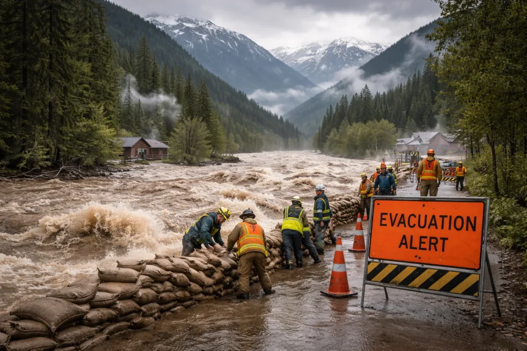
Chapter 4: Frontline Realities—Emergency Response in Action
Provincial Systems and Coordination
British Columbia’s emergency management framework operates through layered coordination:
River Forecast Centre (RFC)
- Operated by the Ministry of Forests, the RFC provides 24/7 monitoring and public advisories
- Uses snow pillow data, river gauges, weather forecasts, and hydrological models to predict flows
- Issues bulletins ranging from “High Streamflow Advisory” to “Flood Warning” with specific impact statements
Provincial Emergency Coordination
- Pre-positions millions of sandbags and kilometers of temporary barriers at strategic locations
- Maintains stockpiles of pumps, generators, and other response equipment
- Coordinates with Canadian Armed Forces for logistical support when municipal resources are overwhelmed
Municipal and Local Response
Local governments serve as first responders, translating provincial warnings into on-the-ground action:
The Township of Langley Model
Following December 2025 rain-on-snow events, Langley implemented a proactive approach:
- Established 24/7 self-serve sandbag stations at municipal works yards
- Implemented systematic ditch and culvert clearing programs before peak melt
- Developed neighborhood-specific flood maps showing drainage patterns and trouble spots
- Created targeted communication protocols for agricultural versus urban areas
First Nations Leadership
Many Indigenous communities have developed innovative approaches:
- The Stó:lō Nation integrates traditional knowledge of Fraser River dynamics with modern forecasting
- Ktunaxa Nation employs community-based monitoring of tributary systems
- Nlaka’pamux communities maintain traditional fish weirs that also function as early-warning systems for flow changes
The Citizen’s Role in Flood Resilience
Individual preparedness remains the foundation of community resilience:
Practical Preparedness Measures
- Property-specific risk assessment: Understanding water flow paths across individual properties
- Backflow valve installation: Preventing sewer backup into basements
- Electrical system modification: Raising panels and appliances above potential flood levels
- Document protection: Digital scanning of essential documents with physical copies stored off-site
Evacuation Readiness
- The “Grab-and-Go” kit: Including medications, pet supplies, important documents, and basic survival gear
- Livestock and animal plans: Pre-arranged evacuation locations and transportation
- Multiple route planning: Accounting for potential road closures and bridge outages
- Communication protocols: Establishing family rendezvous points when cellular networks fail
Chapter 5: The Ecological Dimension—Beyond Human Impact
River Ecosystem Dynamics
Floods represent natural disturbance events that shape aquatic and riparian ecosystems:
Geomorphic Transformation
- Channel widening and migration creates new habitat complexity
- Sediment redistribution forms gravel bars essential for fish spawning
- Large woody debris introduced during floods creates cover and flow diversity
- Nutrient transport from floodplains to channels fuels aquatic food webs
Biological Impacts
- Timing disruption: Early peak flows can strand juvenile salmon in side channels
- Temperature effects: Sudden coldwater releases may shock temperature-adapted species
- Habitat alteration: Some species benefit from renewed habitat while others suffer displacement
- Invasive species spread: Floods can transport invasive plants and animals to new watersheds
The Wildlife Dilemma
Terrestrial ecosystems face profound challenges during flood events:
Upland-Displaced Species
- Large mammals like elk and deer move to higher ground, concentrating populations and increasing predation pressure
- Species with limited mobility, such as amphibians and small mammals, face high mortality
- Disruption of hibernation and denning sites affects reproductive success
The Brisco Elk Herd Case Study
In the Columbia Valley, residents reported in January 2026 that traditional winter habitat had become inaccessible due to unusual mid-winter melting. This forced animals to higher-elevation areas with poorer forage quality, potentially affecting survival rates and increasing human-wildlife conflict at the urban interface.
Chapter 6: The Economic Calculus—Counting the Cost
Direct and Immediate Costs
Flood impacts cascade through economic systems with both immediate and long-term consequences:
Infrastructure Damage
- Transportation network repairs often represent the largest single cost category
- Building and content losses in residential, commercial, and industrial sectors
- Utility restoration including power, water, sewer, and communications systems
- Agricultural infrastructure including irrigation systems, barns, and processing facilities
Business Interruption
- Lost productivity during flood events and recovery periods
- Supply chain disruptions affecting both upstream suppliers and downstream customers
- Tourism impacts extending beyond directly affected areas through perception
- Employment instability in affected regions, particularly seasonal and small business sectors
The Insurance Conundrum
Flood insurance represents a complex and often inadequate component of financial resilience:
Coverage Gaps and Limitations
- Many homeowners mistakenly believe standard policies cover overland flooding
- Business interruption insurance often has lengthy waiting periods before activation
- Agricultural insurance may exclude certain flood-related losses
- High-risk properties face prohibitive premiums or complete unavailability
Government Disaster Financial Assistance (DFA)
- Typically covers only essential, uninsurable losses with maximum limits
- Requires lengthy application processes with complex documentation
- Often fails to cover full replacement value, particularly for specialized items
- May create perverse incentives by effectively subsidizing development in flood-prone areas
Long-Term Economic Transformation
Beyond immediate recovery, floods can reshape regional economies:
Property Value Impacts
- Documented flood history can depress values even with protective measures
- Insurance availability affects mortgage financing and thus market liquidity
- Higher-risk areas may experience demographic shifts as certain populations relocate
Agricultural Restructuring
- Permanent crop loss (orchards, vineyards) may force sectoral changes
- Soil quality alterations through sedimentation or contamination
- Water rights and irrigation system vulnerabilities become investment considerations
Industrial Adaptation
- Manufacturing may relocate from vulnerable floodplains
- Transportation-dependent industries reconsider location decisions
- Energy sector evaluates facility hardening versus relocation
Chapter 7: The Psychological Landscape—Floods in the Human Mind
The Trauma of Displacement
The psychological impacts of flooding extend far beyond property loss:
Immediate Stress Responses
- The acute anxiety of evacuation decisions and execution
- Trauma from witnessing destruction of home and community
- Separation anxiety when families are divided during response
- Survival guilt among those less affected
Long-Term Mental Health Consequences
- Post-traumatic stress disorder prevalence increases significantly in flooded communities
- Depression and anxiety disorders correlate with prolonged displacement
- Substance use often increases as a coping mechanism
- Interpersonal conflict rises under financial and housing stress
Community Cohesion and Fracture
Floods simultaneously test and transform social bonds:
The Emergence of “Therapeutic Community”
- Initial response often generates remarkable cooperation and mutual aid
- Shared hardship can strengthen neighborhood and community ties
- Volunteer efforts provide purpose and meaning amid chaos
- Informal support networks often prove more responsive than formal systems
The Divisions of Recovery
- Inequitable access to resources can create lasting resentment
- Different recovery timelines strain relationships between neighbors
- Blame attribution—toward governments, upstream communities, or development patterns—creates social fractures
- Secondary displacement when some cannot return creates community fragmentation
Intergenerational Impacts
The memory of flood becomes embedded in community identity:
Narrative Formation
- Community stories emphasize resilience, loss, or injustice depending on recovery experience
- Anniversary observations can reinforce trauma or celebrate recovery
- Flood markers and memorials physically embed the event in community space
Behavioral Adaptation
- Changed risk perception affects future decision-making
- Preparedness culture may become embedded or fade with generational turnover
- Land use preferences shift, sometimes toward safer locations, sometimes toward denial of risk
Chapter 8: The Drought Connection—From Deluge to Scarcity
The Hydrological Paradox
The relationship between spring flood and summer drought represents British Columbia’s central water management challenge:
The Storage Trade-off
- Gradual snowmelt through spring and early summer recharges soil moisture and aquifers
- Rapid melt sends water quickly to the ocean, bypassing seasonal storage
- Groundwater systems particularly depend on extended infiltration periods
The 2018 Case Example
Following significant spring snowmelt and flooding, British Columbia experienced one of its worst wildfire seasons. The rapid melt provided little residual moisture for summer, while the floods damaged irrigation infrastructure needed for drought mitigation—a cruel synergy of extremes.
Climate Change Amplification
Scientific projections suggest increasing volatility:
The “Whiplash” Effect
- Climate models project increased precipitation variability
- Warmer atmosphere holds more moisture, increasing both extreme rainfall and evaporation
- Shorter snow-covered seasons concentrate melt into narrower windows
- Earlier melt onset creates longer dry periods before autumn rains
Regional Differentiation
- Coastal areas face more rain-dominated systems with reduced snowpack
- Interior regions may see increased precipitation but as rain rather than snow
- Northern areas experience the greatest warming, affecting permafrost and ice dynamics
Chapter 9: Indigenous Knowledge and Water Wisdom
Traditional Understanding of River Systems
Indigenous communities possess millennia of observation-based knowledge:
Seasonal Round Integration
- Traditional place names often encode hydrological information
- Ceremonial calendars align with specific river conditions and fish runs
- Resource harvesting patterns adapted to normal flood regimes
- Story systems contain encoded observations of extreme events
Observation-Based Forecasting
- Animal behavior as indicators of changing conditions
- Plant phenology signaling seasonal progression
- Ice formation patterns predicting spring melt characteristics
- Atmospheric signs preceding significant weather shifts
Integrating Knowledge Systems
Innovative approaches combine traditional and scientific understanding:
The Stó:lō-SRFC Collaboration
- Traditional knowledge of Fraser River dynamics informs modern modeling
- Elder observations provide ground-truthing for satellite data
- Historical flood markers corroborate paleohydrological reconstructions
- Seasonal indicators supplement instrumental records
Community-Based Monitoring
- Indigenous Guardian programs track local conditions
- Youth engagement in data collection builds intergenerational knowledge transfer
- Language revitalization through environmental terminology
- Digital tools allowing traditional knowledge mapping
Chapter 10: Technological Frontiers in Flood Management
Monitoring and Prediction Advances
Emerging technologies offer improved understanding of flood risk:
Remote Sensing Capabilities
- Satellite-based snow cover mapping at increasingly high resolution
- LIDAR (Light Detection and Ranging) creating precise digital elevation models
- Synthetic Aperture Radar (SAR) measuring snow water equivalent through cloud cover
- Drone-based monitoring of river conditions and ice formation
Modeling Innovations
- Ensemble forecasting incorporating multiple climate scenarios
- Machine learning algorithms identifying patterns in complex hydrological data
- Real-time data assimilation adjusting forecasts as conditions evolve
- High-resolution watershed modeling at community scales
Communication and Warning Systems
Technology transforms how information reaches those at risk:
Targeted Alerting
- Location-based messaging to specific floodplain areas
- Multilingual and accessible format options
- Integration with weather radios and emergency broadcast systems
- Two-way communication allowing situation reporting from the public
Visualization Tools
- Interactive flood inundation maps showing various scenarios
- Virtual reality simulations for emergency planning and public education
- Social media integration with authoritative information sources
- Mobile applications with property-specific risk information
Chapter 11: Policy and Governance—Building Systemic Resilience
The 2024 BC Flood Strategy
British Columbia’s framework for integrated flood management emphasizes:
Key Principles
- Adaptive management with regular review and adjustment
- Multiple lines of defense combining structural and non-structural measures
- Shared responsibility across government, private sector, and individuals
- Ecosystem-based approaches working with natural processes
Implementation Mechanisms
- Integrated Flood Management Plans (IFMPs) for major watersheds
- Updated floodplain mapping with climate change allowances
- Revised development standards for flood-prone areas
- Cross-ministry coordination through the Flood Strategy Secretariat
Land Use Planning Dilemmas
Managing development in floodplains represents perhaps the most challenging policy area:
The Retreat Option
- Property buyouts in highest-risk areas
- Transferable development rights redirecting growth to safer locations
- Conservation easements maintaining floodplain function
- Legacy issues of existing development in vulnerable locations
The Defend Option
- Cost-benefit analysis of protective infrastructure
- Engineering standards accounting for climate change
- Maintenance and financing responsibilities
- Residual risk behind even the best protection
Financial Instruments for Resilience
Innovative approaches to funding flood risk reduction:
Risk-Based Insurance
- Clear risk signaling through premiums
- Bundled incentives for risk reduction measures
- Catastrophe bonds transferring risk to capital markets
- Public-private partnerships for major infrastructure
Development Charges
- Impact fees reflecting true flood protection costs
- Dedicated revenue streams for maintenance and improvement
- Value capture from protected properties
- Cross-subsidization from safer to riskier areas
Chapter 12: Community Innovations—Local Solutions to Global Problems
Nature-Based Solutions in Action
Across British Columbia, communities implement innovative approaches:
Wetland Restoration
- The Sumas River projects reconnecting floodplain wetlands
- Little Campbell River restoration improving water retention
- Comox Valley wetland complexes attenuating peak flows
- Columbia Valley marsh enhancement projects
Agricultural Adaptation
- Delta farm floodable crop trials
- Okanagan water banking and managed aquifer recharge
- Fraser Valley drainage management cooperatives
- Peace River region drought-flood resilient cropping systems
Citizen Science and Community Monitoring
Grassroots efforts complement formal systems:
Community-Based Observations
- Stream level monitoring by local volunteers
- Snow depth measurements in data-sparse areas
- Photographic records documenting conditions and changes
- Traditional knowledge documentation projects
Education and Capacity Building
- School-based monitoring programs
- Workshop series on household flood preparedness
- Neighborhood response team training
- Intergenerational knowledge sharing events
Epilogue: The New Hydrological Reality
As British Columbia faces the spring of 2026, the profound snowpack in its mountains represents more than a seasonal phenomenon—it embodies the complex challenges of a changing climate. The technical measurements—127% of normal, with regional variations from 70% to 175%—tell only part of the story. The complete narrative encompasses ecological shifts, economic vulnerabilities, psychological impacts, and profound questions about how societies adapt to increasing environmental volatility.
The difference between catastrophic flood and managed release, between summer drought and sustainable supply, hinges on countless decisions made at individual, community, and systemic levels. It depends on the integration of scientific forecasting with traditional wisdom, on balancing engineered solutions with natural processes, and on recognizing that flood management and drought preparedness are not competing priorities but interconnected necessities.
British Columbia stands at a hydrological crossroads, facing what experts term “a new regime.” The choices made today—about where to build, how to protect, what to preserve, and how to adapt—will resonate for generations. The snowpack currently gracing the province’s peaks will melt, as it always does. The question is whether its passage will be remembered as another disaster or as the moment British Columbia began navigating wisely toward a more resilient future.
In this endeavor, there are no simple solutions, only complex adaptations. There are no permanent victories, only continuous efforts to understand and work with the water that both sustains and challenges this extraordinary province. As the mountains relinquish their winter burden, they offer not just water, but an opportunity—to build communities that respect rivers’ power, that value water’s worth, and that recognize our fundamental connection to the hydrological cycles that shape this land.