Prologue: The Ghost in the Sky
We live on a blue planet, a world of oceans and continents where rivers carve canyons and shape civilizations. We can see the Mississippi, the Nile, and the Amazon—these arteries of the Earth we can touch and chart. But there is another river system, far more powerful, that flows silently and invisibly above our heads. It is not fed by rain but by the sun’s heat. It is not confined by riverbanks but is a shifting, serpentine vein of moisture that weaves through the lower atmosphere, connecting the tropics to the poles.
For millennia, humans have been at the mercy of this invisible river. It brings life-giving rain to parched lands and unleashes catastrophic floods that wash away cities. Yet, because it is made of vapor, not liquid water, we were blind to it for most of history.
Only in the last three decades have we developed the technology to see it. Using satellites that peer through the clouds and track the heat signature of moisture, we have mapped these aerial veins. The discovery was staggering: the Amazon River, the mightiest on Earth, is dwarfed by the flow of water vapor churning through the atmosphere.
To understand the water crisis, the flood warnings, and the shifting climate patterns of the 21st century, we must first look up. We must track the invisible river.
Part I: The Anatomy of an Invisible River
The Birth of a Sky River
The story of an atmospheric river begins in the warm cauldron of the tropical oceans. Here, the sun’s relentless energy pounds the surface, causing massive amounts of seawater to evaporate. The air becomes thick with humidity, laden with the potential for rain. But it doesn’t just stay put. The Earth’s rotation and global wind patterns act like a massive conveyor belt. They pull this moisture-laden air toward the poles.
Instead of spreading out evenly, this movement organizes into narrow filaments. Imagine a jet stream, but instead of fast-moving air, it is a fast-moving river of water vapor. These are atmospheric rivers: long, sinuous ribbons of concentrated moisture stretching for thousands of kilometers, yet measuring only a few hundred kilometers wide—a delicate ribbon of extreme power in the vast emptiness of the atmosphere.
The formation of these rivers is a complex interplay of atmospheric dynamics. It begins with the Intertropical Convergence Zone, a belt of low pressure near the equator where trade winds from the Northern and Southern Hemispheres meet. Here, the sun-heated air rises, cools, and releases its moisture as torrential tropical rains. But the story doesn’t end there. The upper-level winds, particularly the subtropical jet stream, act as a steering mechanism. They draw this moisture poleward, but not in a uniform blanket. Instead, the interaction of the jet stream with mid-latitude cyclones creates concentrated corridors of moisture transport. These corridors are the atmospheric rivers—the narrow, transient, but intensely powerful channels that move vast quantities of water vapor across the globe.
The process is akin to a fire hose. The tropics are the water source, the jet stream is the nozzle, and the mid-latitude weather systems are the hand that aims the stream. The result is a focused, high-velocity plume of moisture that can travel for thousands of miles before encountering a mountain range or a cold front that forces it to rise and release its cargo.
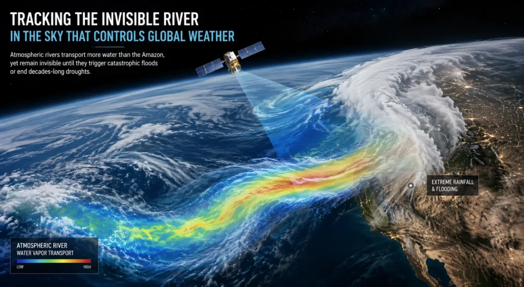
A Window into the Invisible
For a long time, these rivers were predicted but unobserved. The water vapor is invisible to the naked eye; it often sits beneath layers of clouds, hiding from traditional weather satellites that look for visual cues. The breakthrough came with the development of satellite telemetry that measures total precipitable water (TPW). By analyzing microwave radiation emitted by the atmosphere, satellites like those in the Global Precipitation Measurement (GPM) mission can map the concentration of water vapor in the atmosphere as if painting a picture of the “rainfall footprint”. On a satellite map, an atmospheric river appears as a vivid, elongated plume stretching from the tropics toward the continents. It looks uncannily like a river delta on a map, snaking its way across the ocean.
The COSMIC (Constellation Observing System for Meteorology, Ionosphere, and Climate) mission, using GPS radio occultation, has allowed scientists to take a “slice” of these rivers, revealing their vertical structure. They are shallow, usually confined to the lowest 1-2.5 kilometers of the atmosphere, yet they are dense with moisture, carrying a flow of water that is truly biblical in scale. It is through these technological eyes that we have finally begun to map the invisible.
The microwave radiation detected by these satellites is particularly telling. Water vapor absorbs and emits microwave radiation at specific frequencies. By measuring the intensity of this radiation across different channels, scientists can calculate the total amount of water vapor in a column of the atmosphere. The resulting maps reveal the atmospheric rivers as bright, sinuous bands against the darker, drier background. These maps have revolutionized our understanding of global hydrology, revealing that these narrow corridors are responsible for the vast majority of poleward moisture transport in the mid-latitudes.
The satellites also provide other crucial information: wind speed, cloud top temperature, and precipitation intensity. By combining these data streams, forecasters can not only see the river but also gauge its strength and predict its path. The technology has progressed rapidly since the early days, when scientists had to rely on sparse weather balloons and ship reports. Today, a constellation of satellites provides near-real-time coverage of the entire globe, allowing us to track these rivers as they form, evolve, and make landfall.
Part II: The Metrics of Immensity
The Amazon of the Sky
To grasp the scale of these rivers, we must use the Earth’s great surface rivers as a yardstick. The Amazon River, at its mouth, discharges roughly 1.6 x 10^8 kg of water per second. An average atmospheric river moves a volume of vapor that is comparable, but often much greater. Scholars have estimated that the moisture transport in these “tropospheric rivers” was about 38% greater than the flow of the Amazon.
Lest we think this is an anomaly, scientists have calculated that a particularly intense atmospheric river can carry 27 times the flow of the Mississippi River. The instantaneous water vapor flux in a mid-strength atmospheric river is roughly equivalent to the flow of 27 Mississippi Rivers combined. These “Amazon-scale” events are the heavy lifters of the water cycle, accounting for over 90% of the poleward water vapor transport in the mid-latitudes.
To put this in perspective, consider that the Amazon River carries approximately 209,000 cubic meters of water per second at its peak. A strong atmospheric river can carry more than 600,000 cubic meters per second. This is water in vapor form, not liquid, which means it has the potential to fall as rain across a vast area. The energy involved in transporting this much water vapor is immense. It takes approximately 2.26 megajoules of energy to evaporate one kilogram of water. The total energy required to lift an atmospheric river’s worth of water from the ocean surface is measured in terawatts, dwarfing the energy consumption of the entire human civilization.
Furthermore, these rivers are not steady-state features. They pulse and pulse, with their intensity waxing and waning over days. A single atmospheric river event can transport more water than all of the rivers on Earth combined over the same period. This is why they have such a profound impact on global weather. They are the primary mechanism by which the tropics shed their excess heat and moisture to the higher latitudes.
The Scale of Impact
The December 2025 storms that lashed Washington State are a perfect example of this scale in action. Satellite data from NASA’s IMERG (Integrated Multi-satellitE Retrievals for GPM) algorithm showed two distinct “precipitation trails” stretching from the tropics to the US West Coast.
Over the Pacific Ocean, the rainfall was modest, but the imagery revealed the immense stream of water vapor being transported. When that steam hit the Olympic Mountains and the Cascades, it was forced upward. As it rose, it cooled, and the invisible vapor condensed into torrents of rain. IMERG estimated that, in the first half of December alone, the mountain regions received over 24 inches of liquid-equivalent precipitation. This was enough to break river gauges, wash out highways, and cause landslides. It was a stark reminder that the “Amazon” flowing over our heads can pour itself out on a single city in a matter of days.
The impact of such an event extends far beyond the immediate flooding. Consider the economic toll: roads are damaged, bridges are washed out, and power lines are downed. The cost of recovery runs into the billions of dollars. But the impact also includes the disruption of supply chains, the destruction of crops, and the displacement of communities. In the case of Washington State, the December 2025 storms triggered mudslides that blocked rail lines, preventing goods from reaching the coast. For weeks, the region was cut off from vital supplies.
The ecological impact is also significant. Heavy rains can cause soil erosion, stripping nutrients from the land. The runoff can carry pollutants into rivers and estuaries, harming aquatic life. In some cases, the sheer force of the water can reshape the landscape, carving new channels and destroying habitats. The invisible river, when it makes landfall, becomes a visible force of nature, reminding us of its power and its capacity for both creation and destruction.
Part III: The Life-Givers
The “Drought Busters”
For all their destructive potential, atmospheric rivers are essential to life on Earth. They are the planet’s natural mechanism for distributing heat and moisture. For regions like the West Coast of North America, they are the primary water supply. In California, atmospheric rivers account for 30% to 50% of the annual precipitation. It is these few winter storms that fill the reservoirs, saturate the soil, and create the snowpack in the Sierra Nevada that feeds the state’s agriculture and cities for the rest of the year.
The role of atmospheric rivers in ending droughts is critical. Their arrival can be the turning point in a dry season, replenishing water supplies and reviving agriculture. When they are absent, droughts persist. According to research, up to 74% of West Coast droughts are brought to an end by the arrival of an atmospheric river. They are the “drought busters”. In the winter of 2022-2023, California went from 98% drought coverage to just 36% after a “family” of about a dozen atmospheric rivers hit the coast. The snowpack swelled, and the relief was tangible. They are a vital source of freshwater for the human population.
Consider the Central Valley of California, one of the most productive agricultural regions in the world. It relies heavily on the water stored in the Sierra Nevada snowpack. That snowpack is largely built by atmospheric rivers. Without these winter storms, the valley would be a desert. The impact of a single atmospheric river on the state’s water supply can be immense, providing billions of gallons of water that will be used to irrigate crops, support cities, and maintain ecosystems.
The impact extends beyond the West Coast. In the Pacific Northwest, atmospheric rivers contribute to the region’s lush forests and abundant water supply. In the southwestern United States, they are the primary source of moisture for the Colorado River Basin, which supplies water to more than 40 million people. In Europe, atmospheric rivers from the Atlantic bring rain to the British Isles, France, and Spain. In Asia, they replenish the water supplies of Japan, China, and Korea. These rivers are the lifeblood of the planet, sustaining ecosystems and civilizations alike.
A Balancing Act
The science of atmospheric rivers is shifting from pure observation to management. The Center for Western Weather and Water Extremes (CW3E) at Scripps Institution of Oceanography has developed an Atmospheric River Scale (Category 1-5) to rate these storms. This scale helps water managers decide how to operate reservoirs.
A Category 1 or 2 storm is seen as mostly beneficial; it is the slow, soaking rain that recharges groundwater. It is a “water supply” event. However, Category 4 and 5 storms are “primarily hazardous,” capable of overwhelming flood infrastructure. The goal is to harness the water from a weak storm and leave room in the dam to catch the water from a strong one. It is a delicate dance of flood control and water conservation.
The scale is based on the intensity and duration of the atmospheric river, as well as the amount of moisture it transports. A Category 1 storm is relatively weak, producing light to moderate rain. A Category 5 storm is an extreme event, producing heavy rain and flooding. The scale provides a common language for forecasters, water managers, and emergency responders to assess the threat and take appropriate action.
For water managers, the challenge is to balance the need to store water for the dry season with the need to release water to prevent flooding. If a reservoir is too full when a Category 4 or 5 storm hits, the dam may be forced to release water, which could exacerbate downstream flooding. On the other hand, if the reservoir is too empty, a Category 1 or 2 storm may not provide enough water to meet the summer demand. The ability to forecast the intensity of an atmospheric river is, therefore, crucial for making the right decisions.
Forecast-Informed Reservoir Operations are being tested in California, using satellite and aircraft data to guide decisions about when to release water from dams. This approach integrates the latest weather forecasts into reservoir management, allowing operators to anticipate the arrival of an atmospheric river and adjust their operations accordingly. The results have been promising, showing that it is possible to reduce flood risk while maximizing water storage.
Part IV: The Harbingers of Destruction
The Wrath of a Category 5 Storm
When an atmospheric river makes landfall, it is a collision of air and rock. As the moisture-laden air is forced to climb mountain ranges, the water vapor cools, condenses, and turns into rain or snow. This process is known as orographic lift. The physical geometry of the land amplifies the storm; the same river that produced a trace of rain over the ocean can produce catastrophic, record-breaking flooding over the mountains.
The devastation that follows is often exponential in its damage. In the western United States, atmospheric rivers are the primary drivers of flood damages, responsible for roughly $1.1 billion in annual flood damages. This is because the duration and intensity of the storm—the amount of water falling—compound the damage. Research highlights that for the last 40 years, atmospheric rivers have been the primary drivers of flood damages in the western US.
The orographic lift is a powerful mechanism. As the air rises, it cools at the adiabatic lapse rate, which is approximately 10 degrees Celsius per kilometer. The cooling causes the water vapor to condense into cloud droplets, releasing latent heat in the process. This heat further fuels the storm, creating a positive feedback loop that intensifies the precipitation. The result is that the mountains receive far more rain than the coastal plains. In some cases, the difference can be a factor of ten or more. This makes the mountains particularly vulnerable to flooding, as the torrential rain rapidly saturates the soil and triggers landslides.
The damage from a Category 5 storm is not limited to the immediate flooding. The cost of recovery is immense, as roads are washed out, bridges are destroyed, and power lines are downed. The disruption to transportation can last for weeks or even months, isolating communities and hindering relief efforts. The impact on the economy is also significant, as businesses are forced to close, crops are destroyed, and supply chains are disrupted. The human cost is even greater, as people are displaced from their homes, and sometimes, lives are lost.
Anatomy of a “Family” Event
One of the most dangerous aspects of these rivers is that they don’t always travel alone. They often occur in “families”. A single isolated storm might be absorbed by dry soil. But a sequence of back-to-back storms saturates the ground and swells the rivers, setting the stage for catastrophic failure.
In December 2022-January 2023, a series of at least 12 atmospheric rivers hit the West Coast. While they relieved the drought, they also caused the Pajaro River levee to break, flooding an entire community. Historically, 81% of levee breaks in California’s Central Valley are associated with atmospheric rivers. It is in these sequences that the “life-giving” rain becomes a destructive wall of water.
The impact of a “family” of atmospheric rivers is cumulative. The first storm saturates the ground, reducing the capacity of the soil to absorb water. The second storm fills the streams and rivers, raising water levels. The third storm, coming on the heels of the first two, can push the rivers over their banks, causing widespread flooding. The levee breaches are often the result of prolonged high water, as the water pressure gradually weakens the structure. The sequences can be devastating, as communities have little time to recover between storms, and the resources of emergency responders are stretched to the limit.
The 2022-2023 season was a stark reminder of the power of atmospheric river families. California had been in a severe drought, and the arrival of the storms was initially welcomed. But as the storms kept coming, the welcome turned to alarm. The state was pummeled by one storm after another, with virtually no break in between. The cumulative rainfall broke records, and the flooding forced thousands of people to evacuate. The damage was widespread, and the cost of recovery ran into the billions of dollars. The event underscored the need to be prepared for the worst, as even a beneficial feature like an atmospheric river can become a destructive force when it comes in a relentless sequence.
The Madeira Tragedy
The story of the 2010 Madeira flood event serves as a chilling case study of a non-North American impact. Satellite data shows a massive atmospheric river stretching across the Atlantic, streaming moisture from the Caribbean toward Europe. The satellite signatures were clear: a focused plume of total precipitable water with an unusually strong low-level jet. This plume ran into the mountainous island of Madeira, Portugal. The “unusually strong high-level jet” crossed the moisture plume, creating the perfect atmospheric conditions for devastation. The resulting rainfall triggered flash floods and mudslides, causing hundreds of casualties and massive infrastructure damage.
The event was not a freak accident; it was a perfect storm of dynamics that scientists are now learning to identify on satellite maps.
The Madeira disaster is a textbook example of how atmospheric rivers can affect regions far from the tropics. The island was hit by a narrow, focused stream of moisture that had originated in the Caribbean and travelled across the Atlantic Ocean. The mountainous terrain of Madeira acted as a barrier, forcing the air to rise and condense. The result was rainfall amounts that exceeded 500 millimeters in 24 hours in some places. The flash floods swept through the island’s valleys, destroying homes, bridges, and roads. The death toll was over 40, and the economic impact was severe.
The event was a wake-up call for Europe, which had previously thought of atmospheric rivers as a primarily North American phenomenon. In recent years, scientists have discovered that atmospheric rivers affect many parts of the world, including Europe, the Middle East, and Australia. The problem is that many regions are not prepared for such events, as their infrastructure is not designed to handle the extreme rainfall. The Madeira disaster highlighted the need for better forecasting and preparedness, and it spurred research into the impacts of atmospheric rivers in other parts of the world.
Part V: Chasing the Dragons
The Hunters in the Sky
Atmospheric rivers are tricky to study because they are invisible. Clouds obscure them from satellites, and the ocean lacks weather stations. This is where the “storm hunters” come in. It’s a high-stakes operation involving aircraft from organizations like the Air Force Reserve and NOAA. In early 2024, scientists like Anna Wilson were flying through these storms in Gulfstream IV jets, dropping “sondes” (cylindrical sensors) into the heart of the river. As the sensors parachuted down, they sent back real-time data on temperature, pressure, wind, and—crucially—moisture.
These flights are the frontline of forecasting. “We do giant race tracks across the Pacific Ocean,” explains Capt. Nate Wordal. They fly from Japan to Hawaii, following the moisture as it brews, to get a “look” at the data before the storm hits the coast. This data is fed directly into weather models. It is the difference between knowing a storm is coming and knowing precisely how much rain will fall, allowing emergency officials to issue warnings or order evacuations.
The process is both routine and perilous. The aircraft fly through the heart of the storm, where conditions can be severe. The pilots must navigate powerful updrafts and downdrafts, as well as turbulence and icing. The scientists on board work in a cramped cabin, monitoring the instruments and releasing the sondes at precise intervals. The job requires a combination of technical expertise and nerves of steel. But the rewards are immense. The data collected by these flights is invaluable for improving the accuracy of weather models, which in turn helps to protect lives and property.
The sondes are essentially miniature weather stations, packed with sensors and a radio transmitter. They are dropped from the aircraft and, as they descend, they collect data on the vertical structure of the atmosphere. This data is transmitted back to the aircraft and then to forecast centers on the ground. The sondes provide crucial information about the humidity, temperature, and wind speed at different altitudes, which is exactly the information needed to understand the strength and path of an atmospheric river.
The “Atmospheric River Reconnaissance” Program
Since 2016, the Atmospheric River Reconnaissance (AR Recon) program has been building a weather network in the Pacific. Led by Marty Ralph at Scripps, the program coordinates flights to specifically target the atmospheric river itself, not just the cyclone it’s attached to. The goal is to reduce uncertainty. When a weather model has accurate data about the moisture content of an atmospheric river, the forecast for precipitation is vastly improved. This translates into smarter water management—deciding whether to release water from a dam to create capacity, or hold it back to ensure water supplies. It is a remarkable example of using technology to “negotiate” with an invisible force.
The AR Recon program represents a shift in thinking. Previously, weather models focused primarily on the dynamics of the cyclone—the low-pressure system that is often associated with an atmospheric river. However, research showed that it was the moisture content of the atmospheric river itself that was the key to predicting precipitation. By targeting the atmospheric river directly, the AR Recon program provides data that is uniquely valuable for improving forecasts.
The program is a collaboration between the US and the international community. It involves aircraft from NOAA, the US Air Force, and other agencies, as well as scientists from universities and research institutes. The data collected by the program is shared widely, benefiting forecasters around the world. The AR Recon program is a testament to the power of international cooperation in addressing a global challenge. It shows that, by working together, we can make significant progress in understanding and predicting these powerful forces of nature.
Part VI: A Warming Atmosphere, A Swelling River
The Thermodynamic Fuel
The story of atmospheric rivers is changing. Climate change is the new variable. For every degree Celsius the atmosphere warms, it can hold roughly 7% more water vapor. This is the fundamental thermodynamic rule that governs the planet’s hydrology.
As global temperatures rise, the oceans are evaporating more moisture, and the atmosphere has a greater capacity to hold it. This “thirstier” atmosphere supercharges the atmospheric rivers. Research indicates that by 2100, under high emission scenarios, about 70% of mid-latitude atmospheric rivers are projected to carry more moisture than the Amazon River, with 11% of this intensification driven directly by future warming.
The Clausius-Clapeyron relationship, which describes the relationship between temperature and saturation vapor pressure, is the key to understanding this intensification. As the atmosphere warms, its capacity to hold water vapor increases exponentially. This means that even a modest increase in temperature can lead to a significant increase in atmospheric moisture. The result is that the atmospheric rivers of the future will be able to carry much more water vapor than they do today, leading to more intense precipitation events when they make landfall.
The impact of this is already being felt. In recent years, we have seen a number of record-breaking atmospheric river events, such as the 2022-2023 season in California and the 2017 event that caused widespread flooding in the state. These events are consistent with the predictions of climate models, which show that atmospheric rivers will become more intense and more frequent in a warming world. The trend is clear: the invisible river is swelling, and we must prepare for the consequences.
More Than Just Water: The Heat
They are not just “rivers in the sky”; they are also “heat stocks.” They carry vast amounts of latent heat. When that moisture condenses into rain, it releases heat into the atmosphere, warming the local environment.
As climate change intensifies, this heat transport is moving poleward. In high-latitude regions, while the temperature of the storms may be moderated by “Arctic amplification,” there is a noted increase in “humid heatwaves” associated with atmospheric rivers. The combination of high temperature and high humidity (wet-bulb temperatures) is a significant human health risk, especially in areas unaccustomed to tropical humidity.
The latent heat carried by an atmospheric river is immense. Each kilogram of water vapor carries about 2.26 megajoules of latent energy, which is released when the vapor condenses into rain. The total energy released by a single atmospheric river event is equivalent to the explosion of a nuclear bomb every few minutes. This heat can alter the local weather, creating a feedback loop that intensifies the storm. It can also lead to heatwaves, as the warm air is transported to higher latitudes.
The poleward movement of heat is a significant climate feedback. As the Arctic warms, the temperature difference between the tropics and the poles decreases. This can weaken the jet stream, making it more meandering and increasing the likelihood of extreme weather events. The atmospheric rivers, which are often associated with the jet stream, are also affected. The relationship between climate change, the jet stream, and atmospheric rivers is complex, but the overall picture is one of increased volatility and more extreme events.
The Shifting Sands
Atmospheric rivers are not just getting stronger; they are also moving. The satellite era has shown a general poleward shift in their occurrence. They are becoming more frequent in the mid to high latitudes (the Pacific Northwest, Europe, the Arctic) and less frequent in the subtropics.
This is creating a “water divide.” Regions like California are seeing more “rain on snow” events where warm, wet rivers melt the snowpack early, causing flooding and reducing summer water supplies. The Arctic is seeing more moisture, which can lead to ice melt. The subtropics, once reliant on these winter rains, are becoming arid.
The poleward shift is driven by the expansion of the Hadley cells, the large-scale atmospheric circulation patterns that transport heat from the tropics to the poles. As the planet warms, the Hadley cells are expanding, pushing the subtropical dry zones poleward. This means that the regions where atmospheric rivers make landfall are also shifting poleward. The consequences are profound: regions that depend on atmospheric rivers for their water supply may find that the storms are becoming less frequent, leading to more severe droughts. Regions that are not accustomed to these storms may find themselves facing unprecedented floods.
The “rain on snow” events are a particular concern in California. In the past, the snowpack in the Sierra Nevada would slowly melt over the spring and summer, providing a steady supply of water for agriculture and cities. However, as atmospheric rivers become warmer, they are falling as rain at higher altitudes, melting the snowpack prematurely. This leads to flooding in the winter and a reduced water supply in the summer. The problem is likely to worsen as temperatures continue to rise, making water management in California even more challenging.
The Paradox of Extremes
The research reveals a paradoxical future. Even though there may be fewer atmospheric rivers overall, the ones that do occur are going to be much larger—about 25% wider and longer, and carrying 25% more vapor.
This means we are trading a moderate, steady rain for a rare, “fire hose” deluge. This isn’t just a problem for water management; it is a systemic risk. Flood damages from atmospheric rivers across the western U.S. could reach up to $3.2 billion annually by the year 2090—two to three times the historical average. We are moving from a world of “drought busters” to a world where we swing rapidly between “extreme drought” and “extreme flood.”
The paradox is that the total amount of precipitation may not change much in some regions, but the distribution of that precipitation will change dramatically. Instead of receiving a steady rain over several months, a region may receive most of its annual precipitation in a few intense events. This leads to a “flashier” hydrology, with more floods and more droughts. The infrastructure that we have built, which is designed for a more stable climate, will be increasingly unable to cope.
The economic impact is significant. The increased flooding will damage property, disrupt businesses, and strain emergency services. The increased droughts will stress agriculture and water supplies. The cost of adapting to this new reality will be enormous, requiring investments in new infrastructure, better forecasting, and more resilient communities. The invisible river, once a benign feature of the climate, is becoming a threat that we cannot ignore.
Part VII: The Future—Mapping Survival
The Isotope Tracer
To understand the future, we are turning to the past. Scientists are using stable water isotopes—”fossil” signatures in water molecules—to trace where the water vapor in atmospheric rivers comes from and how far it travels. The International Atomic Energy Agency (IAEA) has initiated a Coordinated Research Project integrating isotope tracers into hydrological models. By analyzing the heavy oxygen and hydrogen isotopes in rainfall, scientists can distinguish if the rain came from a local evaporating pool or a distant ocean source. This data helps refine weather models, especially for predicting the path of the moisture plumes in the mid-latitudes.
The isotopes act as a natural tracer, providing a unique fingerprint for different sources of water. For example, water that has evaporated from the Pacific Ocean has a different isotopic composition than water that has evaporated from the Atlantic Ocean. By analyzing the isotopes in rainwater, scientists can determine where the water originated and how it was transported. This information is invaluable for improving our understanding of the global water cycle and for predicting the behavior of atmospheric rivers.
The IAEA’s Coordinated Research Project is bringing together scientists from around the world to develop a standardized approach to isotope tracing. The goal is to integrate isotope data into the weather models that are used to forecast atmospheric rivers, improving the accuracy of those models. The project is still in its early stages, but the initial results are promising. It is a testament to the power of international cooperation and the ingenuity of scientists in tackling a global challenge.
The Human Element
Ultimately, the story of the atmospheric river is the story of our survival. It is the visible “edge” of climate change. We cannot build a wall to keep out the vapor; we must learn to dance with it. The response has been a mix of high-tech forecasting and ancient water management. Forecast-Informed Reservoir Operations are being tested in California, using satellite and aircraft data to guide decisions about when to release water from dams.
It’s a game of precision. “The mild ones are considered beneficial for the water supply, only the very extreme ones are hazardous,” says Qian Cao, a hydrologist at Scripps. We need to learn to embrace the mild ones and survive the catastrophic ones. As Bin Guan of NASA JPL notes, “We tend to highlight the hazardous side but we have to remember that they provide important water supply in dry regions, such as California”.
The human element is perhaps the most important aspect of the atmospheric river story. It is not just about the science; it is about how people respond to the threat and how they manage the resource. The decisions that are made by water managers, emergency responders, and policymakers will determine the impact of these events. The ability to forecast atmospheric rivers has improved dramatically, and the tools are now available to make better decisions. But those tools are only useful if they are used effectively.
The public also has a role to play. People need to be aware of the threat of atmospheric rivers and be prepared to take action when a storm is forecast. This includes having an emergency plan, stocking supplies, and heeding evacuation orders. The more educated and prepared the public is, the less vulnerable they will be to the impacts of these storms. The invisible river is a reminder that we are all connected to the planet’s water cycle, and that we must work together to build a more resilient future.
Epilogue: The Pulse of the Planet
The invisible river is the planet’s circulatory system. It is the connection between the ocean’s heat and the mountain’s snow. It feeds our reservoirs and threatens our cities. It connects the tropics to the Arctic in a continuous, swirling loop of moisture. We are, for the first time, learning to map it, chase it, and understand its moods.
As the 21st century progresses, the tracking of these atmospheric rivers will become as fundamental to our survival as tracking our own heartbeat. In our hands, the technology to see the invisible is a double-edged sword. It warns us of the coming flood, but also reveals the scale of the water we stand to lose. It is a map of our future—a future governed by the invisible rivers in the sky.
The story of the atmospheric river is a story of discovery. It is a testament to human ingenuity, as we have developed the tools to see what was once invisible. It is a story of adaptation, as we learn to live with the power of these storms and to manage their impacts. And it is a story of our future, as the invisible rivers of the sky become an increasingly dominant force in our lives. We have seen that these rivers are the lifeblood of the planet, but also its greatest threat. Our survival depends on understanding them, respecting them, and learning to navigate the turbulent waters of a changing climate. The invisible river is the pulse of the planet, and we must learn to listen to its rhythm.
The journey to understand atmospheric rivers is far from over. New technologies, new models, and new discoveries will continue to shape our understanding of these phenomena. But the fundamental truth remains: the invisible rivers of the sky are a force of nature that we can no longer afford to ignore. They are the key to our water future, and they will determine the fate of nations. As we look to the skies, we must remember that we are not just observing a river; we are observing our own destiny. The invisible river is the ultimate testament to the power and mystery of the natural world, and it is our responsibility to understand it and to protect the life it sustains. The sky is not just above us; it is within us, and it connects us all in a shared, invisible, and powerful flow.