
Imagine the Himalayas not as silent, stoic giants etched against an eternal sky, but as the planet’s greatest, most vulnerable natural reservoir—a living, breathing entity whose frozen pulse dictates the fate of nations. For millennia, these icy peaks have held stories of human adventure, profound spirituality, and immense, life-giving power. Yet, today, a new, critical narrative is unfolding—one dictated by the rapidly accelerating pace of global climate change. The ancient ice is speaking, its message a stark warning of a double-edged sword: catastrophic flooding now, followed by chronic water scarcity later. For the first time, Nepal, a nation historically on the front lines of climate vulnerability, is installing a groundbreaking, permanent technological infrastructure designed to listen, quantify, and respond to this silent, glacial roar.
This is not the script of a distant science fiction novel; it is the urgent reality of a pioneering national mission. Nepal has initiated the deployment of an extensive, real-time glacier monitoring network—a highly sophisticated, resilient web of sensors, stations, and satellite links strategically woven across the unforgiving spine of the Himalayas. This ambitious endeavor represents a momentous shift: moving beyond passive, periodic observation of retreating ice to the active, continuous generation of hyper-local climate data. This data is the nation’s most vital asset in understanding the dramatic ice loss and formulating preemptive defense strategies to safeguard the fragile ecosystems, critical infrastructure, and the nearly two billion people across South Asia who depend on these majestic mountains for survival.
This is the compelling, on-the-ground story of how a resource-constrained nation is leveraging cutting-edge science and proactive courage, transforming widespread anxiety into strategic, data-driven action, and forging a blueprint for climate defense on the roof of the world.
The Whisper Becomes a Roar: Decoding the Unprecedented Pace of the Himalayan Thaw
For decades, the global cryospheric community primarily relied on remote sensing—periodic satellite images—to track the Himalayan glaciers’ relentless, long-term retreat. These distant snapshots, while confirming the rapid loss of ice mass, estimated to be at least ten times faster than the historic average in recent years, only provided an incomplete picture. The critical questions concerning the subtle, day-to-day mechanisms of melt—the localized differences in the ‘why’ and ‘how fast’—remained shrouded in uncertainty. Scientists lacked the fine-grained, in-situ data to truly predict short-term, high-impact events. Trying to model and mitigate such a complex environmental catastrophe with only intermittent satellite data was like trying to diagnose a patient’s life-threatening, minute-by-minute health crisis using only a few old X-rays.
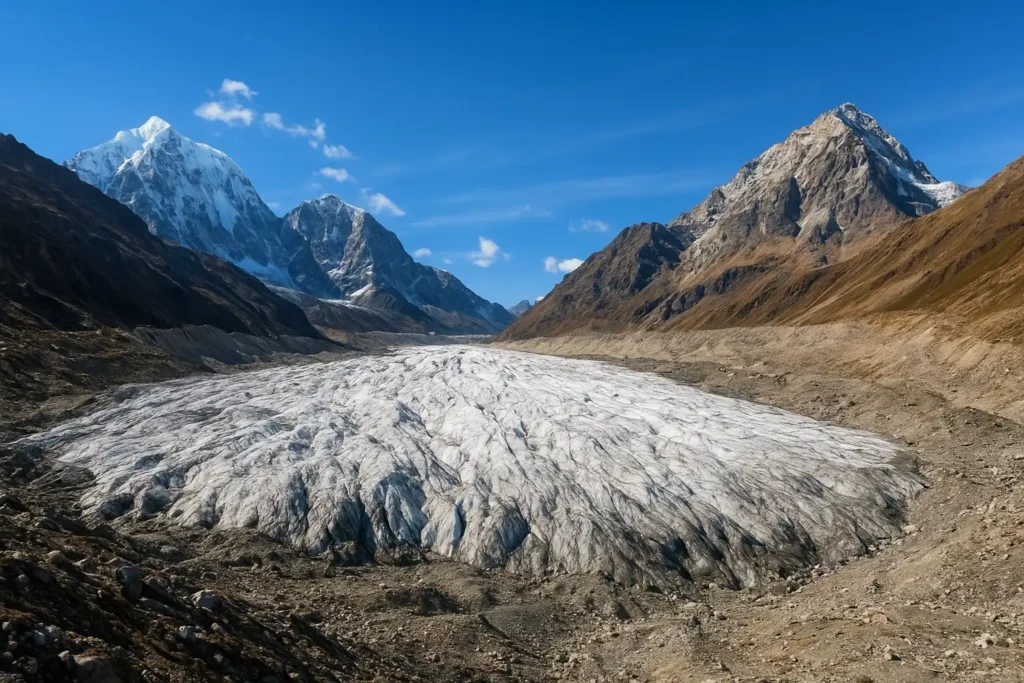
The importance of this ice cannot be overstated. The Himalayan-Hindu Kush mountain range is aptly nicknamed the “Third Pole,” as its ice mass constitutes the largest non-polar repository of frozen fresh water on Earth. These glaciers function as an unparalleled natural regulating mechanism—a colossal, slow-release water tower that stores solid precipitation during the long, cold winter and releases meltwater slowly throughout the dry seasons. This meltwater forms the headwaters of ten of Asia’s most crucial, life-sustaining river systems, including the mighty Indus, Ganges, Brahmaputra, Mekong, and Salween. The discharge from these rivers not only provides drinking water but also irrigates the vast agricultural breadbaskets and fuels the enormous hydroelectric power grids for an astonishing 25% of the global population. The unpredictable and accelerating melt of this critical reserve is therefore an immediate, multi-layered threat to regional water security, food stability, and energy supply, demanding a continuous, high-fidelity monitoring response.
A Network of Hope: The Technological Architecture of Nepal’s Glacier Monitoring System
Nepal’s new initiative signifies a paradigm shift from passive monitoring to active, environmental diagnostics. The country is strategically deploying a permanent constellation of scientific equipment—technological sentinels—on its most critical, high-risk glaciers and glacial lakes. The goal is to move from generalized regional trends to localized, process-based understanding of the melt mechanics.
The technological architecture of this network is designed to withstand the most extreme environmental conditions—sub-zero temperatures, intense solar radiation, heavy snowfall, and high winds—while collecting a multi-faceted stream of synchronous data:
1. The Cryospheric Sensors (Measuring the Ice Loss)
- Ablation Stake Arrays: These are the ground-truth masters. Long, precise rods are drilled deep into the glacier ice in a grid-like pattern across the accumulation and ablation zones. Their daily exposure reveals the exact rate of vertical ice-surface thinning, measured in meters of ice or meters of water equivalent (m w.e.). This is the gold standard for measuring mass balance.
- Ultrasonic Ranging Sensors (URS): Placed on a stable mast above the ice, these sensors use sound waves to continuously measure the distance to the glacier surface below. This provides an automated, high-frequency record of elevation change, capturing melt and accumulation events on an hourly basis, a massive improvement over manual stake readings.
- Ground Penetrating Radar (GPR) Surveys: While not a permanent sensor, GPR is being used periodically at benchmark glaciers to map the thickness and internal structure of the ice. This is crucial for calculating the total remaining ice volume, informing long-term resource planning, and providing vital input for hydrological models.
2. The Meteorological Drivers (Measuring the Cause of Loss)
- Automatic Weather Stations (AWS): These are complex, hardened weather stations deployed at high altitude. They record key atmospheric variables every 10 to 60 minutes, including:
- Air Temperature and Humidity: Direct drivers of sensible and latent heat transfer.
- Wind Speed and Direction: Critical for understanding heat advection and sublimation rates.
- Net Radiometers: These are perhaps the most vital component, measuring the balance between incoming and outgoing shortwave (solar) and longwave (thermal) radiation. This quantifies the exact energy budget driving the melt, especially relevant for understanding the impact of Black Carbon deposition, which dramatically lowers the ice’s albedo (reflectivity).
- Precipitation Gauges: Differentiating between solid (snow) and liquid (rain) precipitation at high altitude, which is crucial for mass balance calculations and understanding how the freezing level is shifting upward.
3. The Hydrological Nerve Center (Measuring the Effect of Loss)
- Glacial Lake Water Level Sensors: These highly specialized sensors are deployed in the dangerous, moraine-dammed glacial lakes. They use high-precision pressure transducers to monitor water depth changes in real-time, instantly alerting scientists to rapid increases from accelerated melt or early signs of moraine instability.
- Seismic and Acoustic Sensors: Installed near moraine dams, these can detect the subtle vibrations or acoustic signals generated by internal ice movement, rockfalls, or the initial stages of a landslide into the lake, which are often the trigger for a catastrophic GLOF event.
- Telemetry and Communication Backbones: The entire system relies on robust, low-power satellite communication to ensure continuous data uplink from extremely remote locations where terrestrial internet or cell service is non-existent. This dedicated telemetry backbone guarantees that the data collected at 5,000 meters reaches the central analysis labs in Kathmandu or international partners within minutes.
This dense, synchronized data stream allows scientists to run sophisticated glacio-hydrological models, moving beyond simple observation to predictive science.
Beyond the Ice: Translating Scientific Data into Civil Defense
The network’s true measure of success lies not in the volume of data collected, but in its swift and effective translation into practical, life-saving civil defense mechanisms and long-term planning tools that impact the populace downstream.
The Early-Warning Sentinel: Mitigating Glacial Lake Outburst Floods (GLOFs)
GLOFs represent the most acute and terrifying natural hazard in the Himalayan context. These unpredictable, high-velocity floods—often releasing volumes equivalent to multiple major city reservoirs in a matter of minutes—can wipe out infrastructure that took years to build.
The monitoring network is the foundation of a sophisticated GLOF Early Warning System (EWS). The real-time data from the lake level, seismic, and meteorological sensors feeds into an automated alert system. For instance, a sudden spike in a lake’s water level combined with a registered seismic signature could immediately trigger a multi-tier warning:
- Level 1 Alert (Scientific): Sent instantly to hydrologists and disaster management centers for expert assessment.
- Level 2 Alert (Community Pre-Warning): A siren or voice-message alert is automatically broadcasted or messaged to downstream villages via radio, satellite phone, or locally installed sirens/speakers.
- Community-Managed Evacuation: This precious lead time, which could be hours instead of minutes, is enough for communities to execute pre-established evacuation protocols to safe zones, dramatically reducing the potential for mass casualties.
The system shifts GLOF management from disaster response to preemptive risk mitigation.
Securing the Future: Planning for Water Scarcity and Food Security
While the GLOF threat is immediate, the long-term threat of water scarcity is chronic and far-reaching. The current period of accelerated melt often leads to increased river flows, masking the impending crisis. However, once the “permanent” ice (the glacier capital) is substantially depleted, the perennial flow of the rivers will drastically diminish during the critical dry season (pre-monsoon and post-monsoon), leading to a crisis known as ‘hydro-stress’.
The glacier mass balance data and runoff models generated by the network are essential tools for national resource planning:
- Hydropower Planning: Data on future projected minimum and maximum flows informs the design and location of new run-of-the-river hydropower projects, ensuring they are resilient to extreme flow variability and GLOF risk.
- Agricultural Adaptation: Water managers can forecast dry season flow deficits decades in advance, guiding national policies on crop diversification (moving toward less water-intensive crops), optimizing irrigation schedules, and managing the inevitable increased reliance on groundwater resources.
- Transboundary Dialogue: By providing scientifically robust, verifiable data on river flow changes, Nepal strengthens its position in water-sharing and resource management discussions with downstream neighbors like India and Bangladesh, transforming a potential geopolitical stressor into a platform for cooperative planning.
The Human Element: Building Community Resilience through Knowledge Transfer
The genius of Nepal’s approach lies in its recognition that the most complex technology is useless without a deeply engaged and knowledgeable human network. The effort extends far beyond installing machinery; it is an intensive, long-term project of human capacity building and knowledge transfer.
Local villagers, especially the youth and community leaders living closest to the vulnerable lakes and glaciers, are being trained not as mere recipients of warnings, but as the system’s de facto operators and sentinels. They receive training in:
- Data Interpretation: Learning to read basic telemetry dashboards, understand alarm thresholds, and recognize environmental signs of risk (e.g., changes in lake color, new moraine cracks).
- Station Maintenance: Learning basic troubleshooting, cleaning solar panels, and minor repairs, ensuring the network’s resilience in the face of extreme weather where scientific teams cannot easily access the site.
- Disaster Drill Implementation: Regularly participating in evacuation drills, refining communication protocols, and mapping safe havens. This integration of ancient, intuitive local knowledge with modern, predictive science creates an essential feedback loop, grounding the high-tech system in practical, lived experience.
This shift empowers mountain communities, moving them from passive subjects of environmental change to active, resilient guardians of their own valleys and the invaluable data stream they host.
A Critical Advancement: Nepal’s Global Role in Cryosphere Research
The international scientific community views Nepal’s commitment as a critical, long-awaited breakthrough. For decades, the remoteness and geopolitical complexities of the Himalayas have resulted in a data deficit—a gaping hole in the global climate monitoring map.
The continuous, high-quality data streaming from Nepal’s benchmark glaciers is now directly feeding into global climate models (GCMs). This regional specificity drastically improves the accuracy of these models, allowing scientists worldwide to make better predictions not only about Himalayan change, but also about far-reaching consequences like global sea-level rise and shifts in monsoon patterns. Nepal is effectively serving as the world’s dedicated cryosphere laboratory, generating essential knowledge for the entire planet. The information provides empirical validation for theoretical models, transforming general climate knowledge into actionable local predictions.
The Ripple Effect: A Model for the Mountain World
The technological deployment and community integration model being perfected in the Nepalese Himalayas offers a powerful and pragmatic blueprint for other high-mountain regions facing similar existential threats, from the South American Andes and the Central Asian Pamirs to the African Rift Valley peaks.
It proves that effective climate adaptation does not require the resources of a developed nation, but rather a clear strategy, political will, and international cooperation focused on tangible, scientific solutions. Nepal’s legacy will be defined not just by its mountains, but by its courage to pioneer a scalable, sustainable, and community-centered approach to climate defense that can be readily adopted across the Mountain World (or “Mountain Cryosphere”).
Looking Ahead: Sustaining the Sentinel Watch
The establishment of this monitoring network is an initial victory, but the work of true climate resilience is continuous. The greatest future challenge is not the collection of data, but its sustained analysis and transformation into long-term policy that guides everything from urban growth to international aid agreements.
Maintaining this complex, high-altitude infrastructure demands sustained funding, political commitment across government transitions, and a continual pipeline of trained local and national cryosphere experts. The network must be expanded to cover the remaining high-risk lakes and key glacier systems, creating a truly comprehensive national shield.
A Story of Proactive Courage: The Heartbeat of the Roof of the World
The epic of Nepal’s glaciers is a microcosm of the global fight against climate change—a story of profound vulnerability woven with threads of incredible ingenuity and resilience. By anchoring a sophisticated technological network across its highest peaks, Nepal is claiming a new role on the global stage.
The real-time data flowing from the roof of the world is infinitely more than just numbers on a dashboard. It is a language of preemptive warning, a precise navigational map for an uncertain future, and an enduring testament to the human spirit’s capacity to face immense, planetary-scale challenges with scientific rigor, intelligence, and proactive courage. The ancient ice is speaking, and in Nepal, for the first time, humanity is not only listening, but learning to act decisively upon its urgent, life-saving message.


Your point of view caught my eye and was very interesting. Thanks. I have a question for you. https://accounts.binance.com/register-person?ref=IHJUI7TF
Thank you for your sharing. I am worried that I lack creative ideas. It is your article that makes me full of hope. Thank you. But, I have a question, can you help me?
I don’t think the title of your article matches the content lol. Just kidding, mainly because I had some doubts after reading the article.
Your article helped me a lot, is there any more related content? Thanks! https://www.binance.com/register?ref=IXBIAFVY