
Introduction: The Cauldron at the Top of the World
There is a moment on the trail to Boiling Lake when the world as you know it ends. It does not end with a sign or a gate. It ends with a sound. One moment, you are deep in the rainforest, surrounded by the soft drip of water from broad leaves, the distant call of a parrot, the rustle of a lizard darting across the path. The air is cool and damp, rich with the smell of wet earth and blooming orchids. You feel small, but you feel comfortable. The forest is a place of life, of green abundance.
Then you push aside a giant fern frond, step over a moss-covered root, and the air changes. It is not a gradual shift. It is a wall of warmth that hits your face, followed by a smell that is sharp, metallic, and ancient—the unmistakable bite of sulfur. The sound of birds fades, replaced by a low, rhythmic rumble. It is a sound you do not just hear; you feel it in your chest, a deep vibration that seems to come from the ground itself, from the rocks, from the very air around you.
You walk forward, climbing a small rise of grey rock, and then you see it.
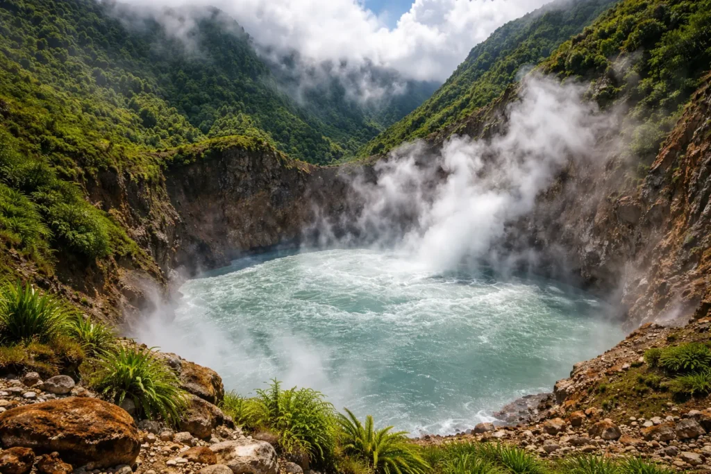
The ground opens up into a massive crater, a natural bowl carved into the side of the mountain. It is filled not with water, but with a churning, seething, grey mass that defies everything you know about lakes. Clouds of steam boil off the surface, drifting across the crater and obscuring the view one moment, then clearing the next to reveal the full horror and majesty of what lies before you.
The center of the lake erupts in a violent column of water and steam, shooting up like a geyser that never stops. Waves of boiling water radiate outward from this central eruption, crashing against the rocky shores with a sound like thunder. The edges of the lake simmer in a constant, roiling boil, sending up bubbles the size of dinner plates.
This is Boiling Lake. It is the second-largest hot spring in the world. At its edges, the water temperature is a constant 92 degrees Celsius—197 degrees Fahrenheit, hot enough to cause third-degree burns in less than a second. The center is so violent, so turbulent, and so impossibly hot that no thermometer has ever been able to measure it. It is a place where the boundary between the surface world and the molten heart of the Earth becomes terrifyingly thin.
For the people of Dominica, the island that is home to this wonder, the lake is a source of pride, a symbol of the raw, untamed power of their homeland. For scientists, it is a living laboratory, a window into the geothermal engines that drive our planet. For adventurers, it is the ultimate challenge, a journey that requires every ounce of physical and mental strength. And for anyone who stands on its shore, it is a humbling reminder that the Earth is not a quiet, settled place. It is alive, it is powerful, and it is still, after billions of years, in the process of becoming.
This is the story of that lake. It is a story that begins millions of years ago, with the birth of an island from the depths of the ocean. It is a story of exploration and discovery, of tragedy and survival, of microscopic life that thrives in the most extreme conditions on Earth, and of the people who have made it their mission to protect this extraordinary place for generations to come.
Part I: The Birth of an Island
The Caribbean’s Hidden Volcano
To understand the Boiling Lake, you must first understand the land it calls home. Dominica is not like other Caribbean islands. While its neighbors—Barbados, Aruba, the Bahamas—are built on ancient, stable limestone platforms or coral reefs, Dominica is a volcanic island, and it is young. In geological terms, it is an infant, still being shaped by the same forces that brought it into existence.
Dominica sits at the heart of the Lesser Antilles volcanic arc. This arc is a chain of islands that stretches from the Virgin Islands in the north to Grenada in the south, forming a gentle curve that separates the Caribbean Sea from the Atlantic Ocean. This arc was created by one of the most fundamental processes in geology: plate tectonics.
Beneath the Caribbean Sea, two massive slabs of the Earth’s crust—the Caribbean Plate and the South American Plate—are slowly colliding. The South American Plate is denser, and as it pushes against the Caribbean Plate, it is forced downward, sliding into the mantle, the layer of semi-molten rock beneath the crust. This process is called subduction.
As the South American Plate descends, it carries water and rock with it. This water lowers the melting point of the surrounding mantle rock, causing it to melt and form magma. This magma, which is lighter than the surrounding rock, rises toward the surface. Over millions of years, repeated eruptions of this magma built up the islands of the Lesser Antilles, including Dominica.
Dominica is unique within this arc because it is the most volcanically active. While many of the other islands are built on the remnants of ancient volcanoes that are now extinct, Dominica’s volcanoes are merely dormant. They are sleeping, not dead. The island is home to nine distinct volcanic centers, each with its own complex system of vents, domes, and craters. These centers are not neatly separated; they overlap and interact, creating a landscape of incredible complexity.
The Nine Volcanic Centers
The nine volcanic centers of Dominica are scattered across the island, from the northern tip to the southern coast. Each has its own character, its own history, and its own signs of life.
- Morne Diablotins: At 1,447 meters (4,747 feet), Morne Diablotins is the highest peak on Dominica. It is a massive, forested volcano that dominates the northern half of the island. Its slopes are covered in dense rainforest, but hidden beneath the green are fumaroles, hot springs, and areas of geothermal activity. Morne Diablotins is considered dormant, but it has not erupted in recorded history.
- Morne Trois Pitons: This is the volcano that concerns us most. Its name means “Mountain of Three Peaks,” and its distinctive silhouette is a national symbol, featured on Dominica’s flag and coat of arms. Morne Trois Pitons is the centerpiece of the national park that bears its name, and it is the home of the Boiling Lake. The volcano is a complex of multiple lava domes, craters, and geothermal fields. It is considered dormant, but its geothermal activity is among the most intense in the Caribbean.
- Morne Plat Pays: Located in the southern part of the island, Morne Plat Pays is another volcanic center with significant geothermal activity. It is home to the Soufrière Sulphur Springs, a popular tourist attraction where hot water bubbles up from the ground. The area around Morne Plat Pays has been the site of several earthquake swarms in recent years, a reminder that the volcano is still active.
- Morne Anglais: This volcano sits just south of Morne Trois Pitons. It is a broad, forested peak that is popular with hikers. While it does not have the intense geothermal activity of its neighbor, it is part of the same volcanic system and is considered potentially active.
- Morne Micotrin: This is the volcano that sits directly beneath the Boiling Lake. Morne Micotrin is a lava dome, a mound of thick, viscous lava that was pushed up from the Earth’s interior. The lake is located in a crater on the flank of this dome. The heat that powers the lake comes from the cooling magma deep beneath Morne Micotrin.
- The Wotten Waven Caldera: This is a large, collapsed volcanic crater located just north of Roseau. The caldera is the source of the hot springs at Wotten Waven, a village famous for its geothermal baths. The area is also known for its “boiling river,” a stream of hot water that flows through the village.
- Grand Soufrière: Located on the east coast of Dominica, Grand Soufrière is a volcanic center that is now largely submerged. It is the site of a large submarine volcano, and it is associated with several hot springs along the coast.
- Fond St. Jean: This volcanic center is located on the southern coast of the island. It is characterized by a series of lava domes and a large, horseshoe-shaped crater that opens to the sea.
- Morne aux Diables: Located at the northern tip of Dominica, Morne aux Diables is the youngest volcanic center on the island. Its name means “Mountain of the Devils,” and it is a broad, forested peak with a large summit crater.
These nine centers are not isolated features. They are all part of a single, interconnected system. The magma that feeds them comes from the same subduction zone. The geothermal fluids that power the hot springs and fumaroles are all part of the same deep circulation system. Dominica is, in essence, a single, massive volcanic edifice, still under construction.
The Kalinago People and the Land
Long before European explorers arrived in the Caribbean, Dominica was inhabited by the Kalinago people. The Kalinago, who called the island “Wait’kubuli”—”Tall is her body”—had a deep and intimate relationship with the land. They understood the volcanoes, the hot springs, and the steam vents in ways that modern science is only beginning to replicate.
For the Kalinago, the landscape was not a collection of inanimate objects. It was alive. The mountains were the bones of ancestors. The rivers were the lifeblood of the Earth. The steam vents and boiling springs were the breath of powerful spirits, places where the ordinary world touched the world of the divine.
The Valley of Desolation, the geothermal field that lies below the Boiling Lake, was considered a particularly sacred place. The Kalinago believed it was a portal to the underworld, a place where the spirits of the dead could be seen and heard. They approached it with reverence and caution. They did not build villages there. They did not hunt there. They left it alone, recognizing it as a place of power that belonged to forces beyond human control.
This reverence for the land is something that has persisted in Dominica, even after centuries of colonization and cultural change. Today, many Dominicans speak of the Boiling Lake with a mixture of pride and respect. They recognize it as a natural wonder that draws visitors from around the world, but they also understand that it is a place that must be treated with care. It is not a theme park. It is not a playground. It is a living, breathing part of their island, and it demands respect.
Part II: The Discovery – A Story of Thirst and Wonder
The Drought of 1870
The story of how the modern world came to know of the Boiling Lake is not a story of scientific exploration or colonial ambition. It is a story of survival, of two men driven by a simple, desperate need: water.
The year was 1870. Dominica was a British colony, and its capital, Roseau, was a bustling port town on the island’s southwest coast. Roseau was a town of wooden buildings, narrow streets, and a thriving trade in sugar, coffee, and limes. But in 1870, Roseau was a town in crisis. A severe drought had gripped the island. The rains that usually fell almost daily in the mountains had stopped. The rivers that flowed down from the interior had shrunk to muddy trickles. The people of Roseau, who depended on these rivers for drinking water, bathing, and washing, were facing a catastrophe.
The British colonial government, responsible for the welfare of the town, took action. They dispatched two men on a mission that would become legendary. Their names were Mr. Watt and Mr. Nicholls.
Watt was a British civil servant, a man of the empire who had been assigned to Dominica to manage the island’s resources. He was a practical man, trained in surveying and engineering. Nicholls was a local Dominican, a man of African and Kalinago descent who knew the island’s interior better than almost anyone. He had spent his life in the forests, hunting, trapping, and exploring. He knew the rivers, the mountains, and the hidden valleys that no European had ever seen.
Their mission was simple: follow the Roseau River upstream into the heart of the island, find the source of the water, and determine if there was a way to secure a more reliable supply for the capital. They were not explorers in the romantic sense. They were surveyors, armed with machetes, compasses, and a desperate sense of purpose.
Hacking Through the Impenetrable
In 1870, the interior of Dominica was one of the most unexplored places on Earth. The rainforest was a wall of green, so dense that sunlight barely reached the forest floor. Giant gommier trees, some reaching 150 feet tall, formed a canopy that blocked out the sky. Beneath them, a tangled understory of ferns, lianas, and vines created a maze so thick that a person could walk for hours and cover only a few hundred yards.
Watt and Nicholls would have been armed with machetes, hacking a path step by step. Every few feet, they had to stop and cut through a new tangle of vines. The ground was steep and slick with mud. The air was thick with humidity, and the heat was oppressive. They were constantly wet—soaked by rain, by river spray, and by their own sweat. Leeches clung to their legs. Flies buzzed around their faces. The roar of the river was a constant companion, but as they climbed higher, the character of the river began to change.
At first, the change was subtle. The cool, refreshing water of the lower stretches began to feel lukewarm. Then, as they pressed on, it became noticeably warm. Then hot. Steam began to rise from the river in places, creating a thin, ghostly mist that hung over the water. They were entering a geothermal zone. They were not just following a river anymore; they were following a plume of superheated water draining from something immense and powerful upstream.
They must have known, at that moment, that they were onto something extraordinary. The water was too hot to be natural. It was coming from somewhere deep, somewhere where the Earth’s own heat was being released. They pressed on, driven by curiosity as much as by their mission.
The Valley of Desolation
After days of brutal travel, the forest began to thin. The giant trees gave way to stunted, twisted vegetation—ferns and mosses that could tolerate the heat and the sulfurous air. Then, suddenly, the green disappeared entirely. They stepped out of the rainforest and into a landscape that defied description.
They had discovered the Valley of Desolation.
It was a wide, flat valley nestled between steep, forested mountains. But the valley itself was barren. The ground was not soil; it was a thick, grey clay, cracked and steaming. Rivers of hot water snaked across the valley floor, their banks lined with bright yellow crystals of sulfur. Everywhere, the ground hissed. Jets of steam, some as thin as a pencil, others as wide as a door, shot out from cracks in the earth. Mud pots—pools of thick, grey mud—bubbled and splattered, sending up globs of clay that hardened in the air.
The air was thick with the smell of rotten eggs—hydrogen sulfide gas, a sign of active volcanism. The temperature was sweltering, not from the sun, but from the heat radiating from the ground beneath their feet. The ground itself was hot. They could feel it through the soles of their boots. It was a scene from a nightmare, or from the pages of a Jules Verne novel about a journey to the center of the Earth.
They crossed the valley, navigating between the mud pots and steam vents, their boots sinking into the soft clay. They had to be careful. A misstep could mean plunging into a hidden pool of boiling water or breaking through a thin crust into a steam vent. They moved slowly, deliberately, testing the ground with their machetes before putting their full weight on it.
On the far side of the valley, they faced one final obstacle: a steep, forested ridge. It was the highest point they had yet encountered, a wall of green that rose up from the barren valley floor. Exhausted, they began to climb.
The Moment of Discovery
What they saw on the other side of that ridge is now the stuff of legend.
They pulled themselves up over the final rocks, pushed aside the last of the stunted vegetation, and found themselves staring into a massive crater. It was roughly 200 feet across, a perfect cauldron carved into the side of the mountain. And it was filled not with clear, still water, but with a churning, grey, violent mass.
The lake was boiling.
A massive column of water and steam erupted from the center of the lake, shooting up dozens of feet into the air. The eruption was not constant; it pulsed, each surge sending a wave of boiling water crashing against the rocky walls of the crater. The sound was deafening—a deep, rhythmic boom, like a massive steam engine running out of control. The ground beneath their feet vibrated with each pulse.
They stood there, frozen, for what must have been minutes. They had found the source of the hot water. This was the headwater of their river. This was the reason the water downstream was hot. But it was utterly, completely undrinkable. They could not bring this water to Roseau. They could not even approach it.
Watt and Nicholls had failed in their original mission. They would return to Roseau with empty hands, unable to solve the drought that was crippling the town. But they had succeeded in something far greater. They had discovered one of the most extraordinary natural wonders on Earth.
The Aftermath
Watt and Nicholls returned to Roseau with maps and descriptions. The news spread quickly. The British colonial authorities were initially skeptical. A lake that boiled? It sounded like a traveler’s tall tale. But Watt was a respected civil servant, and Nicholls was known for his honesty. When other explorers confirmed their discovery, the Boiling Lake was added to the maps of the island.
Within a few years, the lake had become a destination for scientists, adventurers, and curious travelers. The first scientific expedition arrived in 1875, led by a British geologist named Henry Watts. Watts confirmed the temperature of the water at the edges (92 degrees Celsius) and made the first detailed observations of the lake’s behavior. He noted the violent bubbling in the center, the steam clouds that constantly rose from the surface, and the strange, grey color of the water. He also noted the eerie silence of the surrounding area, the absence of birds and animals near the crater.
Watts’ report, published in scientific journals in Europe, cemented the Boiling Lake’s reputation as one of the world’s great natural wonders. It was compared to Iceland’s famous geysers, to New Zealand’s pink and white terraces, to the hot springs of Yellowstone. But the Boiling Lake was different. It was not a geyser that erupted periodically. It was a lake that boiled constantly, without cease. It was, and remains, a phenomenon unique in the world.
Part III: The Anatomy of a Cauldron
A Flooded Fumarole
So what exactly is the Boiling Lake? The simplest way to describe it is as a flooded fumarole. But to understand what that means, you have to understand the plumbing of a volcano.
A fumarole is an opening in the Earth’s crust, usually near a volcano, from which steam and volcanic gases escape. You see them all over the Valley of Desolation—those hissing cracks in the ground. A fumarole is essentially a pressure release valve for the geothermal system below. Magma deep beneath the surface heats up groundwater, turning it into steam. That steam, under immense pressure, finds its way to the surface through cracks and fissures. When it emerges, it creates a fumarole.
Now, imagine that one of those fumaroles is located in a natural depression, a bowl-shaped crater in the side of a mountain. Imagine that this crater is constantly fed by two things: heavy tropical rainfall and a small, hot waterfall that cascades into one side. The water collects in the crater, but the fumarole at the bottom does not stop venting. It is not a crack that can be sealed. It is a direct conduit to a superheated world deep beneath the surface.
The water that collects in the crater is trapped. It cannot drain away because the fumarole is a point of outflow, not inflow. The volcanic gases and superheated steam from below bubble up through the water, heating it from the bottom. Over time, the entire body of water becomes a gigantic, perpetually boiling cauldron.
This is why the lake behaves the way it does. It is not a hot spring in the sense of a pool that fills and then overflows. It is a dynamic system, a balance between the water coming in (rain and the hot waterfall) and the water being boiled away as steam (by the heat from below). When the balance is stable, the lake maintains a constant level. When the balance shifts, the lake changes—sometimes dramatically.
The Heat Source
The heat that powers the Boiling Lake comes from the cooling magma beneath Morne Micotrin, the lava dome on whose flank the lake sits. This magma is not liquid rock; it is a thick, pasty mass of partially molten material that is slowly cooling and solidifying. As it cools, it releases heat into the surrounding rock.
This heat is transferred to groundwater through a process of convection. Cold rainwater seeps down through cracks in the rock, reaching depths of thousands of feet. As it descends, it gets closer to the cooling magma and is heated to temperatures that can exceed 300 degrees Celsius. Under the immense pressure at those depths, the water does not boil. It remains liquid, but it is superheated.
This superheated water is less dense than the cooler water around it, so it begins to rise. It flows upward through the same cracks and fissures that allowed the cold water to descend. As it rises, the pressure decreases, and the water begins to turn to steam. By the time it reaches the fumarole at the bottom of the lake, it is a mixture of superheated water and steam, erupting into the lake with tremendous force.
This system is self-sustaining as long as two things remain constant: the supply of cold rainwater to feed the system, and the supply of heat from the cooling magma below. As long as both are present, the lake will continue to boil.
The Unmeasurable Center
One of the most intriguing facts about the Boiling Lake is that we do not know exactly how hot it is at its core. We know the temperature at the edges is a constant 92 degrees Celsius. That is just one degree below the boiling point of water at sea level. But the edges are the coolest part of the lake. They are where the lake water comes into contact with the cooler rocks of the crater wall, and where the inflow of rainwater and the hot waterfall helps to moderate the temperature.
The center is a different story entirely. This is where the main fumarole, the main volcanic vent, is located. Here, superheated water and steam from deep within the Earth erupt to the surface. The water in this central column is under immense pressure from the weight of the lake above it. Under pressure, water can be heated to temperatures well above 100 degrees Celsius without turning to steam. This is the same principle that allows a pressure cooker to cook food faster.
Geologists estimate that the temperature at the vent itself could be 120, 150, or even 200 degrees Celsius. But no one has ever been able to measure it. Any attempt to lower a thermometer into the center results in the device being smashed by the violent churning or destroyed by the extreme heat. The center of Boiling Lake remains one of the few places on Earth where the exact temperature is not just unknown, but unknowable with current technology.
The Grey Color: A Signature of Life and Geology
Why is the lake grey? If you imagine a boiling lake, you might picture crystal-clear water roiling like a pot on a stove. But the Boiling Lake is a thick, opaque, milky grey. This color comes from two sources.
First, there are the volcanic minerals. As the superheated water and steam rise from deep within the Earth, they dissolve minerals from the surrounding rock. These minerals include silica, sulfur, and various clays. When the water reaches the surface and cools slightly, these minerals precipitate out, forming tiny particles that hang in the water. This is similar to the “glacial milk” you see in rivers fed by melting glaciers, but in this case, the milk comes from the Earth’s interior rather than from ground-up rock.
Second, and perhaps more fascinating, is the presence of life. The lake is home to extremophiles—microorganisms that thrive in extreme conditions. These are not plants or animals. They are tiny, single-celled organisms called archaea and bacteria. They form a kind of microbial mat, a living carpet of microscopic life, that covers the bottom and sides of the lake. As they live and die, they add to the organic matter suspended in the water, contributing to its cloudy appearance.
These extremophiles are not just a curiosity. They are a window into the history of life on Earth. The earliest life forms on our planet were extremophiles, living in the hot, sulfurous, oxygen-poor environment of early Earth. By studying the microbes in Boiling Lake, scientists can learn about the conditions that gave rise to life itself.
The Water Balance
The Boiling Lake is not a closed system. Water is constantly entering the lake and leaving it. The inputs are two: rainfall and a small waterfall that flows into the lake from the north. The waterfall, known as the “Ghost” waterfall because it often disappears in clouds of steam, is itself a geothermal feature. Its water is hot, a sign that it, too, is fed by the same volcanic system.
The outputs are also two: evaporation and steam. The intense heat of the lake causes water to evaporate constantly. You can see this as the clouds of steam that rise from the surface. In addition, a significant amount of water is lost as steam from the fumarole itself. The vent at the bottom of the lake is constantly releasing superheated steam, which bubbles up through the water and escapes into the atmosphere.
The balance between inputs and outputs determines the lake’s level. In normal conditions, the inputs and outputs are roughly equal, and the lake maintains a stable level. But if rainfall decreases—during a drought, for example—the inputs drop, and the lake level slowly falls. If the fumarole becomes more active, the outputs increase, and the lake level falls. If the fumarole becomes less active, or if the waterfall increases its flow, the lake level rises.
This delicate balance is what makes the lake so dynamic. It is not a static feature. It is a living system, constantly adjusting to changes in rainfall, temperature, and the activity of the volcano beneath it.
Part IV: The Mysterious Mood Swings of the Lake
The Drainage Events
If the Boiling Lake were simply a pot of water on a permanent stove, it would be remarkable enough. But it is far more dynamic than that. Throughout its recorded history, the lake has exhibited dramatic mood swings, periods where it has drained almost completely, leaving behind a steaming, hissing pit.
The first documented drainage event occurred in 1880, just ten years after the lake’s discovery. Local residents and British colonial officials reported that the water level in the lake began to drop dramatically. The violent boiling in the center subsided. Within a few weeks, the lake was gone. In its place was a deep crater filled with steam and the sound of rushing water deep below the surface. For months, the crater remained empty, a chasm of hot rock and hissing vents. Then, gradually, the water began to return. The lake refilled, and the boiling resumed.
Similar events occurred in the 1970s, and again in 2004 and 2005. These are not volcanic eruptions in the traditional sense. There is no explosion of ash or lava. Instead, it appears to be a kind of internal plumbing issue.
Scientists believe these drainage events happen when the underground system that feeds the lake becomes blocked or experiences a sudden change in pressure. Imagine the lake as a bathtub with a drain that leads to a deep, hot cave. Normally, the water coming in from rain and the hot waterfall is balanced by the water being boiled away as steam. But if the vent at the bottom of the lake becomes partially blocked, pressure builds up below. Eventually, that pressure has to release. It might force the water to drain down into a new, deeper fissure, effectively unplugging the drain. The lake empties from the bottom, leaving only steam.
Then, over time, the pressure equalizes. The underground water system re-stabilizes. The vent clears, and the lake begins to refill from the top. The whole process can take months or even years.
A Window into the Volcano’s Mood
For volcanologists, these drainage events are incredibly valuable. They are a window into the behavior of the volcanic system deep beneath the lake. When the lake drains, scientists can descend into the crater—carefully, with protective gear—to study the vents, measure gas emissions, and collect samples. It is one of the few times they can get a close-up look at the inner workings of a geothermal system.
During the 2004–2005 drainage event, a team of scientists from the University of the West Indies and the Dominica National Parks Authority descended into the crater. They wore heat-resistant suits and carried gas masks to protect themselves from the sulfurous fumes. They found that the crater was not empty. It was a deep, narrow pit, perhaps 100 feet deep, with a small, intensely hot pool of water at the bottom. The pool was boiling violently, and steam was rising from every crack in the surrounding rock.
They took samples of the water, the gas, and the rock. They measured the temperature of the pool (which was too hot to measure directly) and the composition of the gas. They found that the gas was rich in carbon dioxide, hydrogen sulfide, and sulfur dioxide—all signs of active volcanism. They also found that the rock lining the crater was heavily altered, transformed by years of exposure to hot, acidic fluids into a crumbly, clay-like substance.
The data they collected during that drainage event has helped scientists better understand the Boiling Lake and the volcanic system that powers it. It has also provided a baseline for monitoring future changes. If the lake drains again—and it will, eventually—scientists will be ready to descend once more and add to their understanding.
The 1880 Event: A Contemporary Account
The 1880 drainage event was described in vivid detail by a British colonial administrator named Sir Henry Hesketh Bell. Bell, who later became the Governor of Dominica, visited the lake shortly after it had drained. His account, published in a scientific journal, gives us a glimpse of what the empty crater looked like:
“The lake had entirely disappeared. In its place was a vast, yawning chasm, perhaps 150 feet deep, with sheer walls of black, glistening rock. From the bottom of this chasm rose a column of steam, so dense and so hot that it was impossible to see the bottom. The noise was deafening—a roar like a thousand steam engines, punctuated by sharp cracks and booms. The ground trembled constantly. It was a scene of indescribable desolation and grandeur.”
Bell’s account captures the awe and terror that the Boiling Lake inspires, even when it is empty. The lake, in its drained state, was perhaps even more frightening than when it was full. It was a raw, open wound in the Earth, a direct view into the geothermal engine that powers the island.
The Refilling
The refilling of the lake is as dramatic as the draining. In 2005, after nearly a year of being empty, the lake began to refill. It did not happen slowly, as a bathtub fills. It happened in fits and starts, with sudden surges of water that caused the lake level to rise by several feet in a single day.
Geologists believe that the refilling occurs when the underground blockage clears. The pressure that had built up during the drainage event is released, and the superheated water that had been trapped in deep fissures is allowed to rise to the surface. This water, still at temperatures well above the boiling point, erupts into the crater, quickly filling it.
The refilling of 2005 was captured on video by a local guide. The video shows the crater, still mostly empty, with a small, violently boiling pool at its center. Then, without warning, a massive geyser of water and steam erupts from the pool, shooting up hundreds of feet into the air. When the geyser subsides, the crater is noticeably fuller. Over the course of a few weeks, the lake returned to its normal level, and the boiling resumed.
For the people of Dominica, the refilling was a relief. The Boiling Lake is a symbol of their island, a source of pride. When it drains, there is a sense of unease, a feeling that something is wrong. When it refills, there is a sense of normalcy restored. The lake is back. The island is as it should be.
Part V: The Valley of Desolation – A Walk Through Hell
The Gateway
No journey to the Boiling Lake is complete without crossing the Valley of Desolation. In fact, you cannot reach the lake without going through it. The valley is the lake’s forecourt, its antechamber, a place that strips away the last vestiges of the comfortable, familiar world and prepares you for the raw power that lies ahead.
The name itself—Valley of Desolation—sounds like something out of a fantasy novel. It was given by early explorers who were struck by the utter absence of life in a landscape surrounded by lush, vibrant rainforest. It is a name that has stuck, and it is a name that fits.
A Landscape from Another World
As you descend from the rainforest into the valley, the change is immediate and dramatic. The temperature rises sharply. The cool, damp air of the forest is replaced by a hot, dry wind that carries the sharp smell of sulfur. The ground beneath your feet changes from rich, dark soil to a slippery, grey clay that cakes to your boots.
The valley floor is a vast, open expanse of grey and yellow. There is no grass, no trees, no flowers. The only plants that survive here are a few hardy ferns and mosses that cling to the very edges of the geothermal zone, where the heat is less intense. The silence of the forest is replaced by a constant, percussive soundscape. Everywhere you look, the Earth is hissing, bubbling, and steaming.
- Mud Pots: These are pools of thick, grey mud that bubble and pop with the consistency of a simmering stew. They range in size from a dinner plate to a small car. The mud is heated from below, and as steam rises through it, it creates a rhythmic, glugging sound. Some mud pots are so active that they splatter mud several feet into the air, creating strange, abstract sculptures on the surrounding rocks. The mud is not just hot; it is also acidic, with a pH that can be as low as 2 or 3. Touching it would cause a chemical burn as well as a thermal burn.
- Fumaroles: These are the steam vents. They appear as cracks in the earth from which jets of steam and gas escape. Some are tiny, barely visible wisps. Others are large, roaring vents that sound like a jet engine. The steam is so hot that it can burn exposed skin if you stand too close. The vents are often rimmed with bright yellow crystals of elemental sulfur, a byproduct of the volcanic gases. Sulfur is a fascinating mineral; it is one of the few elements that can be found in its pure, native form. It is also highly flammable. In the Valley of Desolation, the sulfur deposits are so thick that they can be scraped off the rocks with a knife.
- Hot Streams: Several streams flow through the valley. They look like ordinary mountain streams—clear, fast-flowing water—but they are scalding hot. You can see steam rising from them as they cascade over rocks. It is a strange and disorienting sight: a rushing river that would burn you if you touched it. These streams are fed by the same geothermal system that powers the lake. They are the surface expression of the superheated groundwater that circulates deep beneath the valley.
- The Boiling Pool: Just before you leave the valley to climb the final ridge to the lake, you will pass a feature known as the Boiling Pool. It is a small, circular pool of water, perhaps ten feet across. Unlike the mud pots, this is clear water, but it is in a state of constant, violent boiling. It is a miniature version of the main lake, a preview of what awaits. The water in the Boiling Pool is at the same temperature as the edges of the main lake—92 degrees Celsius. It is a reminder that the geothermal activity in the valley is not just on the surface; it is everywhere, just beneath your feet.
Why the Valley Exists
The Valley of Desolation is not a random geothermal oddity. It is an extension of the same volcanic system that powers the Boiling Lake. Deep beneath the valley floor, there are cracks and fissures that allow superheated water and steam to rise to the surface. The difference is that in the valley, the water does not collect into a single, deep basin. It spreads out across a wider area, creating a diffuse field of vents, pools, and streams.
The reason the valley is so barren is simple: the combination of high heat, acidic gases, and mineral-rich soil makes it impossible for most plants to survive. The sulfur in the soil creates a highly acidic environment. The constant heat bakes the roots of any plant that tries to take hold. And the periodic emissions of steam and gas can kill vegetation in an instant.
But the valley is not entirely lifeless. In the cooler areas, at the edges of the geothermal zone, you can find a few hardy plants. There is a species of fern that has adapted to the high sulfur levels. There is a type of moss that can tolerate the heat. And there are, of course, the extremophiles—the microscopic organisms that thrive in the hot springs and mud pots. These organisms are the reason the mud is grey, the water is cloudy, and the sulfur deposits are often covered in a thin, slimy film. They are the hidden life of the valley, invisible to the naked eye but essential to the ecosystem.
The Dangers of the Valley
The Valley of Desolation is a beautiful and awe-inspiring place, but it is also one of the most dangerous places in Dominica. The dangers are many, and they are not always obvious.
- Thin Crust: The ground in the valley is not solid rock. It is a thin crust of clay and hardened mud, often covering pools of boiling water or steam vents. A misstep can mean breaking through this crust and plunging into water that is near boiling. This is why hikers are strictly instructed to stay on the marked path. The path has been tested and is known to be safe. The ground to either side is not.
- Scalding Water: The streams, mud pots, and pools in the valley are all at temperatures that can cause severe burns. Even a splash can be dangerous. Hikers are warned not to touch anything. The water is not just hot; it is also acidic, which means that even a small splash can cause a chemical burn that is slow to heal.
- Toxic Gases: The steam and gas that rise from the fumaroles contain a mixture of volcanic gases, including hydrogen sulfide, carbon dioxide, and sulfur dioxide. Hydrogen sulfide is poisonous in high concentrations. It is also heavier than air, so it can accumulate in low-lying areas. Carbon dioxide is also heavier than air and can cause asphyxiation if it displaces the oxygen. Guides are trained to recognize the signs of gas accumulation and to keep groups moving through the valley quickly.
- Unstable Terrain: The valley floor is constantly changing. New mud pots form. Old ones collapse. Steam vents shift. The ground is soft and slippery. A slope that was stable yesterday could be a mudslide today. Guides assess the conditions daily and adjust the route accordingly.
Despite these dangers, the Valley of Desolation is a place of profound beauty. It is a reminder that the Earth is not a quiet, settled place. It is a dynamic, living system, constantly changing, constantly renewing. Walking through it is a privilege, but it is also a responsibility. You are a visitor in a world that does not care about your safety. You must treat it with respect.
Part VI: The 1997 Tragedy – A Day of Reckoning
A Cloudless Day
For decades, the Boiling Lake was considered a challenging but safe destination. Hundreds of hikers made the journey every year. Local guides knew the terrain, the weather patterns, and the risks. But on a day in August 1997, the lake reminded everyone that it is ultimately a wild, uncontrollable force of nature.
The day started like any other. A group of hikers, led by a respected local guide named Garth Nicholas, set out from the village of Laudat. The group included visitors from abroad, all eager to see one of the world’s great natural wonders. The weather was typical for Dominica—cloudy but calm, with no signs of the violent storms that sometimes sweep through the mountains.
The hike went smoothly. They crossed the Valley of Desolation, climbed Morne Nicholls, and arrived at the lake. Like all guides, Garth positioned his group at a safe vantage point, a rocky area that was known to be stable and well away from the water’s edge. They stood there, taking in the view, listening to the roar of the boiling water, and watching the steam rise from the cauldron.
The Landslide
What happened next occurred without warning.
High above the lake, on the steep, forested slopes of the crater wall, a massive section of earth gave way. It is likely that the slope had been weakened over time by the constant steam and acidic gases from the lake. The rock in that area was not solid granite; it was hydrothermally altered, meaning it had been transformed by years of exposure to heat and chemicals into a crumbly, clay-like substance.
A heavy rain in the days before might have been the final trigger, saturating the weakened rock and causing it to lose its grip. Whatever the cause, the result was catastrophic.
A massive landslide, thousands of tons of rock, mud, and uprooted trees, plunged down the steep slope and crashed directly into the center of the Boiling Lake. The impact was like a meteor strike. It created a massive wave—a tsunami of boiling water—that surged outwards from the point of impact.
The Wave
The group standing at the edge of the lake had no time to react. The wave, traveling at tremendous speed, swept over the rocky outcrop where they were standing. In an instant, Garth Nicholas and several of the visitors were swept off their feet and into the churning, scalding water.
Panic and chaos erupted. The survivors scrambled for higher ground, screaming for help. Two of the visitors managed to pull themselves out of the water, but they were badly burned. One of the other guides, along with another visitor, risked their own lives by wading back into the shallows to pull others to safety.
When the water finally settled, the toll became clear. Garth Nicholas, the guide who had led countless groups to this lake, was gone. A young man from England, a visitor who had come to see the wonder of the natural world, was also missing. They had been swept into the boiling cauldron. They did not survive.
It was the first recorded fatal incident at the Boiling Lake. It sent shockwaves through the tight-knit community of Dominica and forced a complete reassessment of safety protocols at the site.
Aftermath and Legacy
The 1997 tragedy was a turning point. It was a stark, brutal reminder that the Boiling Lake is not a theme park. It is a dangerous, unpredictable natural environment. The landslide had not been caused by a volcanic eruption or an earthquake. It was simply a slope that had given way, a common geological event that, in this particular location, had catastrophic consequences.
In the years following the tragedy, the Dominica National Parks Authority implemented stricter safety measures. The number of licensed guides was regulated, and training was enhanced. Guides are now required to undergo rigorous first aid training and to constantly assess the stability of the terrain. Visitors are strictly forbidden from approaching the water’s edge. Designated viewing areas were established at a safe distance from the lake.
The tragedy also changed the way people talk about the lake. It is no longer spoken of as simply a tourist attraction. It is spoken of with a deep sense of respect, and a clear understanding that the beauty of the place is inseparable from its danger. Garth Nicholas is remembered as a dedicated guide who loved his island. His story serves as a somber reminder that when you enter a place as powerful as Boiling Lake, you are a visitor in a world that operates by its own rules.
The Garth Nicholas Memorial
In the years since the tragedy, a small memorial was established at the trailhead in Laudat. It is a simple plaque, set into a stone, that bears Garth Nicholas’s name and a brief inscription. It reads, in part: “In memory of Garth Nicholas, guide and friend, who loved these mountains and shared their beauty with the world. May his spirit guide us still.”
For many guides, the memorial is a place of reflection. Before leading a group to the lake, they will often pause at the memorial, paying their respects to a man who died doing what he loved. It is a reminder of the risks they take every day, and of the responsibility they bear for the safety of their clients.
Part VII: Life on the Edge – The Extremophiles
A Sterile Lake?
If you were to look at the Boiling Lake, you might assume it is completely devoid of life. The water is too hot, too acidic, too violent for any fish, plant, or insect to survive. And for the most part, you would be correct. There are no fish swimming in its depths. There are no algae blooms on its surface. It is, by any normal definition, a sterile environment.
But life, as it turns out, is far more tenacious than we often give it credit for. The Boiling Lake is home to a thriving community of extremophiles—microorganisms that not only survive in extreme conditions but actually require them to live.
The Archaea
The most famous residents of the lake are a group of single-celled organisms called archaea. For a long time, scientists classified archaea as a type of bacteria. But in recent decades, they have realized that archaea are something entirely different. They are a separate domain of life, as different from bacteria as bacteria are from humans.
Archaea are ancient. They are thought to be among the oldest life forms on Earth, dating back to a time when the planet was a very different place—a time when the atmosphere had no oxygen, the oceans were full of dissolved iron, and the land was a barren, volcanic wasteland. They thrived in the hot springs, deep-sea vents, and sulfurous pools of early Earth. And they are still thriving today in places like the Boiling Lake.
The archaea in Boiling Lake are thermophiles, meaning they love heat. They have special enzymes and cell membranes that do not break down at high temperatures. In fact, if you cool them down too much, they stop functioning. They are perfectly adapted to a world that would kill any other form of life.
Chemosynthesis: A Different Way to Live
Perhaps the most fascinating thing about these extremophiles is how they get their energy. Most life on Earth, from the tiniest plant to the largest whale, depends on the sun. Plants use photosynthesis to convert sunlight into energy. Animals eat plants or other animals to get that stored energy. But in the Boiling Lake, sunlight is scarce. The water is grey and opaque. The steam clouds often block the sun entirely.
Instead, the archaea in the lake use a process called chemosynthesis. They do not get their energy from the sun. They get it from the chemicals in the volcanic vents. They take in hydrogen sulfide, the gas that gives the lake its rotten egg smell, and combine it with carbon dioxide and oxygen to create organic matter. They are essentially eating the volcano.
This is a profound discovery. Before chemosynthesis was understood, scientists believed that all life on Earth ultimately depended on sunlight. The discovery of chemosynthetic ecosystems—first in deep-sea vents, and later in places like Boiling Lake—revolutionized our understanding of life’s possibilities. It showed that life could exist in the dark, in the cold, in the heat, in places that were previously thought to be uninhabitable.
The Microbial Mat
The archaea and bacteria in the Boiling Lake do not live alone. They form a complex community known as a microbial mat. This mat is a thin, layered film of microorganisms that covers the bottom of the lake and the rocks around its edges. In some places, the mat is so thick that it forms a kind of slimy coating, visible to the naked eye.
The microbial mat is a miniature ecosystem. Different types of organisms live in different layers of the mat. At the top, where the water is cooler and there is more oxygen, you find organisms that can tolerate these conditions. Deeper in the mat, where the temperature is higher and the oxygen is absent, you find organisms that thrive in these extreme conditions. The mat is a living, breathing community, constantly adapting to the changing conditions of the lake.
A Window to Other Worlds
The extremophiles of Boiling Lake are not just a scientific curiosity. They are a window into the search for life beyond Earth.
When scientists look for life on other planets or moons, they do not look for green plants or swimming fish. They look for the conditions that extremophiles need to survive. They look for water, for heat, and for chemical energy sources.
Consider Europa, a moon of Jupiter. Europa is covered in a thick layer of ice, but scientists believe there is a vast, liquid ocean beneath that ice. That ocean is kept from freezing by tidal forces from Jupiter, which generate heat. And at the bottom of that ocean, there are likely hydrothermal vents, similar to the vents that power the Boiling Lake. If there is life on Europa, it would almost certainly be chemosynthetic extremophiles, living in the dark, feeding off the chemicals from the vents.
By studying the microbes in Boiling Lake, scientists can develop the tools and techniques they will need to detect similar life on other worlds. A tiny archaea in a boiling lake in Dominica might, in a very real sense, be our best clue to the existence of life elsewhere in the solar system.
The Role of the University of the West Indies
The scientific study of the Boiling Lake’s extremophiles is led by the University of the West Indies’ Seismic Research Centre. This center, based in Trinidad, is responsible for monitoring volcanic activity across the Caribbean. Its scientists make regular trips to the Boiling Lake to collect samples, measure temperatures, and monitor the lake’s behavior.
The research is not easy. Collecting samples from the lake requires specialized equipment. The scientists use long poles with sampling bottles attached to collect water from the edges. They use temperature probes that can withstand the heat. They wear protective suits and breathing apparatus when approaching the fumaroles. It is dangerous work, but it is essential for understanding the lake and the volcanic system that powers it.
The data collected by the Seismic Research Centre is shared with scientists around the world. The Boiling Lake is part of a global network of geothermal research sites, helping scientists understand the fundamental processes that shape our planet.
Part VIII: The Hike – A Step-by-Step Journey
Preparation
For those who are inspired to make the journey to Boiling Lake, preparation is everything. This is not a walk in the park. It is a full-day, strenuous hike that requires physical fitness, proper gear, and a willingness to embrace discomfort. But for those who are prepared, it is one of the most rewarding experiences on Earth.
The first and most important rule: hire a licensed guide. This is not optional. The trail is complex, the weather is unpredictable, and the terrain is hazardous. Guides are trained to navigate the route, assess conditions, and handle emergencies. They also provide a wealth of knowledge about the history, geology, and ecology of the area. A good guide transforms the hike from a physical challenge into an educational and cultural experience.
The Gear
What you wear and carry can make the difference between a memorable adventure and a miserable ordeal. Here is a checklist of essentials:
- Footwear: Sturdy, waterproof hiking boots with good ankle support. The trail is steep, muddy, and uneven. Sneakers or sandals will not suffice. Your boots should be broken in before the hike. New boots can cause blisters that will make the hike unbearable.
- Clothing: Lightweight, quick-dry materials. Long pants are recommended to protect against scratches from bushes and heat from steam vents. A long-sleeved shirt provides protection from the sun and insects. Avoid cotton. Cotton stays wet and can cause chafing and hypothermia if you get caught in rain.
- Rain Gear: A high-quality, waterproof rain jacket. The rainforest lives up to its name. You will likely encounter rain at some point during the hike. A poncho can work, but a jacket with a hood is better. Rain pants are also recommended, especially during the wet season.
- Backpack: A comfortable daypack to carry water, food, and extra layers. Look for a pack with a waist strap to distribute the weight evenly. You will be carrying this pack for six to eight hours, so comfort is key.
- Water: At least 2 to 3 liters per person. Dehydration is a serious risk, especially in the Valley of Desolation where the heat is intense. Consider carrying a hydration bladder (like a CamelBak) for easy access to water. You can refill your bottles at the Breakfast River, but the water should be treated with purification tablets or a filter.
- Food: Pack a high-energy lunch and plenty of snacks. Think sandwiches, nuts, dried fruit, and energy bars. Avoid heavy, greasy foods that will weigh you down. You will need a steady supply of energy to fuel the hike.
- First Aid Kit: Include blister care, antiseptic wipes, bandages, and any personal medications. Blisters are common on this hike, so bring moleskin or blister bandages. Also include pain relievers like ibuprofen for sore muscles.
- Sunscreen and Insect Repellent: Even in the rainforest, sun exposure is possible, especially on the exposed sections of the trail. Insects, particularly mosquitoes and sand flies, can be a nuisance. A hat is also recommended for sun protection.
- Camera: You will want to capture the views, but be mindful of your footing while taking photos. A waterproof camera or a protective case is a good idea, as rain is always possible.
- Swimsuit and Towel: On the way back, there is a cold, refreshing river called Titou Gorge where many hikers take a dip to cool off. The water is cold, clear, and incredibly refreshing after a long, hot hike.
The Route: A Step-by-Step Guide
Step 1: Laudat to Breakfast River (0–1.5 hours)
The hike begins in the village of Laudat, a small community nestled in the mountains. Your guide will meet you at the trailhead, which is marked by a small sign. The trail starts on a wide, well-maintained path that winds through the rainforest. You cross several suspension bridges that sway gently above deep gorges. The first major landmark is the Breakfast River, a cold, clear stream where you can refill your water bottles. This section is relatively easy and serves as a warm-up. The trail is well-graded, and the forest is beautiful. Take your time and enjoy the scenery.
Step 2: Breakfast River to the Valley of Desolation (1.5–3 hours)
After Breakfast River, the trail becomes steeper and more challenging. You begin a steady climb through the forest. The air cools as you ascend. You will hear the calls of parrots and see giant ferns and orchids along the way. The trail narrows, and the footing becomes more uneven. You will encounter sections of steep, muddy slope that require careful footing. Eventually, the forest begins to thin, and you catch your first whiff of sulfur. The temperature starts to rise. You emerge from the trees and descend into the Valley of Desolation.
Step 3: Crossing the Valley of Desolation (3–4 hours)
This is the most unique and challenging section of the hike. You will spend about an hour navigating the valley floor. The path is marked, but you must stay on it. The ground is slippery and unstable. You will pass bubbling mud pots, hissing steam vents, and scalding hot streams. The heat radiating from the ground is intense. Take your time, drink water, and listen to your guide’s instructions. The valley is a sensory overload—the sounds, the smells, the heat. It is a place that demands your full attention.
Step 4: The Ascent to Morne Nicholls (4–5 hours)
On the far side of the valley, you face the final climb. Morne Nicholls is a steep, forested ridge. The trail is narrow and can be muddy. This is the most physically demanding part of the hike. Your legs will burn. Your lungs will work. But when you reach the top, you are rewarded with your first view of the Boiling Lake. The ridge is named after one of the lake’s discoverers, Nicholls. Standing there, looking down at the lake, you can imagine what he must have felt when he first saw it—awe, terror, wonder.
Step 5: The Boiling Lake (5–6 hours)
You have arrived. You will spend about 30 to 45 minutes at the lake. Your guide will direct you to a safe viewing area, well away from the water’s edge. From here, you can see the full scale of the lake—the grey, churning water, the massive steam clouds, the violent eruption in the center. You will feel the heat on your face and hear the deep rumble of the boiling water. This is the moment that makes all the effort worthwhile. Take your photos, but also take a moment to just stand and absorb the experience. It is a place that changes you.
Step 6: The Return (6–9 hours)
The return journey is the same route in reverse. It will feel different. The climbs you descended on the way in become climbs on the way out. The fatigue will set in. But you have the memory of the lake to carry you. Many hikers stop at Titou Gorge on the way back for a swim in the cold, clear water. It is the perfect end to an epic day. Your guide will lead you back to Laudat, where you can rest, rehydrate, and reflect on what you have experienced.
Tips for a Successful Hike
- Start Early: Most hikers begin between 6:00 and 7:00 AM. This allows you to complete the majority of the hike before the midday heat and reduces the risk of afternoon thunderstorms, which are common in the mountains.
- Pace Yourself: The hike is not a race. Take your time. Stop to catch your breath. Drink water regularly. Listen to your body. If you need to rest, tell your guide.
- Listen to Your Guide: Your guide knows the trail, the conditions, and the risks. Follow their instructions without question. If they tell you to stop, stop. If they tell you to stay on the path, stay on the path.
- Be Prepared for Rain: Even on a sunny day, rain is possible. Keep your rain jacket accessible. Protect your electronics in waterproof bags.
- Leave No Trace: Pack out everything you pack in. Do not litter. Do not take rocks or plants as souvenirs. The Boiling Lake is a protected area. Treat it with respect.
Part IX: Beyond the Lake – Dominica’s Geothermal Wonderland
A Geothermal Paradise
The Boiling Lake is the crown jewel of Dominica’s geothermal landscape, but it is far from the only one. The island is dotted with hot springs, steam vents, and volcanic features that are accessible to visitors without the need for a nine-mile hike.
Wotten Waven: Just a short drive from the capital, Roseau, is the village of Wotten Waven. This area is known for its natural hot springs. Locals have built small pools where you can soak in the geothermal waters. It is a popular spot for relaxation and is said to have therapeutic properties. The hot water is channeled directly from the ground, and the pools range from warm to very hot. Some pools are fed by natural waterfalls, creating a mix of hot and cold water. It is a wonderful place to spend an afternoon after the Boiling Lake hike.
Sulphur Springs: Near the town of Soufrière, there is a roadside sulfur spring. Here, hot water bubbles up from the ground and flows into a small pool. The water is rich in sulfur and other minerals, and it is a popular spot for locals who believe it has healing properties. The spring is easy to access, with parking right next to it. It is a good option for visitors who want to experience Dominica’s geothermal activity without a strenuous hike.
Trafalgar Falls: While not a hot spring, Trafalgar Falls is one of Dominica’s most famous natural attractions. It is a pair of spectacular waterfalls—the “Father” and the “Mother”—that cascade down a steep cliff. The Father is the taller of the two, plunging 125 feet into a deep pool. The Mother is smaller but equally beautiful. The area around the falls is lush and green, and there is a hot spring nearby where you can soak your feet after the short hike. The falls are located in the Morne Trois Pitons National Park, just a short drive from Laudat.
The Boiling River: In the village of Wotten Waven, there is a stream known as the Boiling River. It is not boiling in the same sense as the lake, but it is heated by the same geothermal system. The water is warm enough to be comfortable for bathing, and locals have built small pools along its course. It is a peaceful, relaxing spot, surrounded by lush vegetation.
The Bubble Beach: On the south coast of Dominica, near the village of Soufrière, there is a beach known as Bubble Beach. Here, volcanic gases bubble up through the sand, creating a natural spa experience. At low tide, you can dig a hole in the sand and watch as hot water and steam bubble up from below. It is a unique and memorable experience.
The Waitukubuli National Trail
For those who want to immerse themselves even deeper in Dominica’s natural beauty, the Waitukubuli National Trail is a must. This is the longest hiking trail in the Caribbean, stretching 115 miles from the south of the island to the north. It is divided into 14 segments, each with its own unique character. Some segments pass through rainforest, others along the coast, and some through geothermal areas. Segment 8 passes near the Boiling Lake, making it a popular route for experienced hikers who want to combine multiple days of adventure.
The trail was developed with the help of the Kalinago people, and its name, Waitukubuli, is the Kalinago name for Dominica. It is a way to experience the island the way the Kalinago did—on foot, moving through the landscape, connecting with the land. For hikers who complete the entire trail, it is a journey of weeks, a true immersion in the natural and cultural heritage of Dominica.
Dominica’s Waterfalls
Dominica is known as the “Land of 365 Rivers,” and with all those rivers come waterfalls. The island is dotted with hundreds of waterfalls, from small, hidden cascades to massive, thundering falls. Some of the most famous include:
- Middleham Falls: A 200-foot waterfall located in the Morne Trois Pitons National Park. The hike to Middleham Falls is a moderate one, about an hour each way, through beautiful rainforest. The falls plunge into a deep pool that is perfect for swimming.
- Emerald Pool: A beautiful, 40-foot waterfall located in a lush, green grotto. The pool at the base is a deep, emerald green, and it is a popular spot for swimming. The hike to the pool is short and easy, making it accessible to visitors of all ages and fitness levels.
- Sari Sari Falls: A stunning, 165-foot waterfall located on the east coast of Dominica. The hike to Sari Sari Falls is a challenging one, involving river crossings and steep climbs, but the reward is a spectacular waterfall that cascades into a deep, turquoise pool.
- Victoria Falls: A 100-foot waterfall located on the east coast. The hike to Victoria Falls is a moderate one, following a river through a beautiful valley. The falls are wide and powerful, and the pool at the base is perfect for swimming.
Part X: Conservation and the Future
A UNESCO World Heritage Site
In 1997, the same year as the tragic landslide, Morne Trois Pitons National Park was designated a UNESCO World Heritage Site. This was a monumental achievement for Dominica. It placed the park—and by extension, the Boiling Lake—on the global list of places that have “outstanding universal value.”
The UNESCO designation is not just a title. It comes with a responsibility to protect the area for future generations. The park is managed by the Dominica National Parks Authority, which works to balance the demands of tourism with the need for conservation.
The Challenges of Tourism
Tourism is a vital part of Dominica’s economy. The Boiling Lake is one of the island’s biggest attractions, drawing visitors from around the world. But with tourism comes impact. The trail to the lake sees thousands of hikers a year. Each footstep can cause erosion. Improperly disposed waste can contaminate the water. Visitors who stray from the path can damage fragile geothermal features or put themselves in danger.
The National Parks Authority has implemented several measures to manage these impacts:
- Licensed Guides: Only guides who have completed a rigorous training program are authorized to lead groups to the lake. This ensures that visitors are accompanied by someone who knows the terrain and the rules. Guides are required to pass a written exam, a practical test, and a first aid certification. They are also required to complete continuing education courses to stay current on safety protocols and environmental management.
- Trail Maintenance: The trail is regularly maintained to prevent erosion. Boardwalks have been installed in the most sensitive areas of the Valley of Desolation. Drainage channels have been built to divert water away from the trail. Sections that become too eroded are rerouted to allow the old path to recover.
- Waste Management: Hikers are required to pack out all trash. There are no trash cans on the trail. This “leave no trace” policy helps keep the area pristine. Guides carry trash bags and encourage their groups to pick up any litter they see. Human waste is also a concern; hikers are instructed to use designated restroom facilities at the trailhead and to pack out any waste if they need to go on the trail.
- Education: Guides educate visitors about the fragility of the environment and the importance of staying on the path. They explain the dangers of touching the water or approaching the steam vents. They also share the history and cultural significance of the area, helping visitors develop a deeper appreciation for the place.
The Threat of Climate Change
Like all of Dominica, the Boiling Lake faces threats from a changing climate. The island is in the hurricane belt, and in recent years, it has been hit by increasingly powerful storms. In 2017, Hurricane Maria, a Category 5 storm, devastated Dominica. The hurricane caused widespread damage to the island’s infrastructure, including the trail to the Boiling Lake. It took months to clear the fallen trees and repair the damage.
Climate change is also expected to alter rainfall patterns in the Caribbean. The Boiling Lake relies on a delicate balance between water inflow (rain and the hot waterfall) and outflow (evaporation and steam). If rainfall decreases significantly, the lake’s level could drop. If rainfall increases, it could alter the temperature dynamics. Scientists are monitoring these changes closely, but the long-term effects are still unknown.
Geothermal Energy: A Double-Edged Sword
Dominica sits on a vast reservoir of geothermal energy. In recent years, the government has explored the possibility of harnessing this energy to generate electricity. Geothermal power plants use the same superheated water and steam that power the Boiling Lake to turn turbines and generate electricity. It is a clean, renewable source of energy that could help Dominica reduce its dependence on imported fossil fuels.
But geothermal development is a double-edged sword. Drilling into the geothermal system could potentially affect the features that depend on it, including the Boiling Lake. Scientists are studying the potential impacts carefully. Any development would need to be done in a way that does not harm the lake or other geothermal features. It is a delicate balance, and one that the people of Dominica are approaching with caution.
A Model of Resilience
Despite these challenges, Dominica remains committed to protecting its natural heritage. The island has set an ambitious goal of becoming the world’s first climate-resilient nation. This means rebuilding infrastructure to withstand stronger storms, diversifying its economy, and protecting its natural resources, which are its greatest asset.
The Boiling Lake is a symbol of that resilience. It has survived hurricanes, earthquakes, landslides, and its own internal drainage events. It has been there for millennia, and with careful stewardship, it will be there for millennia more.
Conclusion: A Place That Changes You
There are places in the world that you visit, enjoy, and then leave behind. You take a photograph, buy a souvenir, and the memory gradually fades. The Boiling Lake is not one of those places.
The Boiling Lake changes you. It changes you physically. Your legs ache for days after the hike. Your shoulders are sore from the pack. You have cuts and scrapes you do not remember getting. You are exhausted in a way that only a true physical challenge can produce.
It changes you mentally. You have seen something that defies easy description. You have stood at the edge of a cauldron of boiling water, felt the heat on your face, heard the deep rumble of the Earth, and smelled the sulfur in the air. You have crossed a valley that looks like the surface of another planet. You have pushed your body to its limits and found that it could go further than you thought.
It changes you emotionally. There is a humility that comes from standing before something so much larger and more powerful than yourself. The Boiling Lake does not care about your schedule, your problems, or your plans. It does what it has done for centuries, powered by the same forces that built the island itself. It is a reminder that we are small, that the Earth is ancient, and that there are still places in this world that remain wild, untamed, and gloriously indifferent to our existence.
For the people of Dominica, the Boiling Lake is a source of pride, a connection to their volcanic homeland, and a reminder of the power that lies beneath their feet. For the scientists who study it, it is a living laboratory, a window into the geothermal engine that drives the island. For the guides who lead hikers to its shores, it is a sacred place, to be approached with respect and shared with care.
And for the traveler who makes the journey—who wakes up before dawn, laces up their boots, and spends a day pushing through rainforest, crossing a desolate valley, and climbing a steep ridge to stand at the edge of a boiling cauldron—it is something more. It is a story they will tell for the rest of their lives. It is a memory that will never fade.
The Boiling Lake is not just the world’s second-largest hot spring. It is a testament to the power of our planet, a challenge to those who seek it, and a wonder that reminds us of the extraordinary beauty and danger that exist in the natural world. It is, quite simply, one of the most remarkable places on Earth.
Frequently Asked Questions (FAQs)
Q1: How long does the hike to Boiling Lake take?
The round trip typically takes 5 to 7 hours, depending on the pace of the group and the weather conditions. It is a 9-mile (14.5 km) hike with significant elevation gain. The exact time can vary based on fitness levels, how long the group spends at the lake, and the weather.
Q2: Is the hike suitable for children?
The hike is strenuous and is generally not recommended for young children. Older teenagers who are physically fit and have hiking experience may be able to complete it, but parents should carefully assess their child’s ability and endurance. The trail involves steep climbs, slippery sections, and exposure to heat and volcanic gases. It is not a safe environment for young children.
Q3: What is the best time of year to visit?
The dry season, from December to April, is generally the best time. The trails are less muddy, and the risk of heavy rain is lower. However, Dominica’s rainforest climate means rain is always a possibility. The wet season, from June to October, can bring heavy rains that make the trail muddy and slippery. It is also hurricane season, and the trail may be closed if a storm is approaching.
Q4: Do I need to book a guide in advance?
Yes, it is highly recommended. Licensed guides can be booked through tour operators in Roseau, Portsmouth, or at hotels. During the peak tourist season (December to April), guides can be in high demand, so advance booking is advised. Many guides can be booked online before your trip.
Q5: Can I see the lake without doing the hike?
No. The Boiling Lake is located deep within the Morne Trois Pitons National Park and is only accessible by foot. There is no road or vehicle access. The hike is the only way to see it.
Q6: What happens if the weather is bad?
If there is a severe weather warning or if conditions on the trail are deemed unsafe, the National Parks Authority may close the trail. Your guide will make the final call. Safety is the top priority. If the trail is closed, your guide will work with you to reschedule or to arrange an alternative activity.
Q7: Has the lake ever erupted?
The lake itself does not erupt. The volcanic activity is hydrothermal, meaning it involves water and steam, not magma. The drainage events are the closest it comes to dramatic change. There is no risk of a volcanic eruption from the lake itself, but the surrounding volcanic system is active and is monitored by scientists.
Q8: Is it safe to drink the water from the streams?
The streams below the geothermal zone are generally safe to drink if treated with purification tablets or a filter. However, water sources within the geothermal area should never be consumed. They are hot, acidic, and contaminated with volcanic gases. Your guide can advise on safe water sources.
Q9: What should I do if I get injured on the trail?
Your guide is trained in first aid and will carry a basic medical kit. In the event of a serious injury, the guide will coordinate with park authorities to arrange an evacuation. This is one of the many reasons why hiring a guide is essential. Cell phone reception is limited on the trail, but guides have satellite communication devices or radios for emergencies.
Q10: Will I see wildlife on the hike?
Yes. The Morne Trois Pitons National Park is home to a rich diversity of wildlife. You may see the Sisserou parrot (the national bird), the Jaco parrot, hummingbirds, frogs, and lizards. The forest is also home to the agouti and the manicou (a type of opossum), though these are more elusive and are rarely seen during the day. The Sisserou parrot, in particular, is a rare and endangered species found only in Dominica. Seeing one in the wild is a special experience.
Q11: What is the altitude of the lake?
The Boiling Lake is located at an altitude of approximately 2,500 feet (762 meters) above sea level. The hike involves significant elevation changes, with the highest point being the ridge above the lake at around 3,000 feet.
Q12: Are there restroom facilities on the trail?
There are no restroom facilities on the trail. There are restrooms at the trailhead in Laudat. Hikers are instructed to use these facilities before starting the hike. If you need to use the restroom on the trail, your guide will help you find a safe spot away from water sources and the trail, and you will need to pack out any waste.
Q13: Can I take my dog on the hike?
No. Pets are not allowed in the Morne Trois Pitons National Park. The trail is too steep and dangerous for dogs, and the geothermal features pose a serious risk to animals.
Q14: Is there an age limit for the hike?
There is no official age limit, but the hike is not recommended for young children or for elderly individuals with limited mobility. The decision is left to the guide, who will assess the fitness and ability of each member of the group before starting the hike.
Q15: What should I do if I have a medical condition?
If you have a medical condition, such as heart problems, respiratory issues, or joint problems, you should consult your doctor before attempting the hike. You should also inform your guide of any medical conditions before the hike begins. The guide can then make accommodations or recommend against the hike if it is unsafe.
Q16: How much does the hike cost?
The cost varies depending on the guide and the size of the group. Typically, the cost includes the guide’s services, park entrance fees, and sometimes transportation to and from the trailhead. It is best to contact guides directly for current pricing.
Q17: What is the cancellation policy?
Cancellation policies vary by guide. Most guides require advance notice for cancellations and may charge a fee for last-minute cancellations. If the trail is closed due to weather or safety concerns, most guides will offer a full refund or the opportunity to reschedule.
Q18: Can I do the hike on my own without a guide?
Technically, it is possible to hike to the Boiling Lake without a guide, but it is strongly discouraged. The trail is complex, and the risks are significant. In recent years, the National Parks Authority has encouraged all visitors to hire licensed guides for safety and conservation reasons. If you choose to hike without a guide, you do so at your own risk.
Q19: What is the history of the name “Morne Nicholls”?
Morne Nicholls, the ridge that overlooks the Boiling Lake, is named after one of the lake’s discoverers, Mr. Nicholls, the local Dominican who accompanied Mr. Watt on the 1870 expedition. The naming of the ridge is a tribute to his role in the discovery and his knowledge of the island’s interior.
Q20: Is the Boiling Lake the largest hot spring in the world?
No, it is the second-largest. The largest is Frying Pan Lake in New Zealand, which is located in the Waimangu Volcanic Rift Valley. Frying Pan Lake is larger in surface area, but the Boiling Lake is deeper and more consistently active.

Y999gamelogin is my secret weapon for unwinding after work! Seriously, give it a try. You might just like it. y999gamelogin
1eegame definitely stands out. The login is straightforward, and I’ve had some enjoyable sessions. Give it a whirl! 1eegame
666casino is a solid choice if you’re looking for a casino experience. I’ve found it to be pretty reliable. Good for chilling and having some fun. 666casino