

Imagine a place so strange, so perfectly layered, that it feels like Mother Nature’s own Russian nesting doll. A secret hidden in plain sight, where islands live inside lakes, which live on bigger islands, which sit in even larger lakes. This isn’t a scene from a fantasy novel or a dream. This is a real place. This is the Taal Volcano in the Philippines, and its story is one of fire, water, and unbelievable beauty.
For centuries, travelers, geologists, and locals have been captivated by this natural wonder. They call it the “island within a lake on an island within a lake on an island.” Just saying it feels like a tongue twister, and seeing it with your own eyes feels like witnessing a magic trick on a planetary scale. How did such an impossible place come to be? The answer is a thrilling tale written over thousands of years by the powerful forces beneath the Earth’s crust, a saga of apocalyptic destruction, patient creation, and the fragile balance of life.
A Glimpse from Above: Unraveling the Layers of the Puzzle
Before we dive into the dramatic history, let’s untangle this geographical puzzle piece by piece. It’s like solving a fascinating riddle that nature spent millennia crafting.
- The Foundation: Luzon Island. This is the biggest stage, the first and largest doll in the set. Luzon is the largest and most populous island in the Philippine archipelago, a land of bustling megacities like Manila, ancient Banaue rice terraces carved into mountainsides, and lush, tropical forests. It’s the main canvas on which our entire story is painted, providing the geological foundation for the drama that unfolds in its heart.
- The First Frame: Taal Lake. Nestled in the coastal province of Batangas on Luzon Island is a massive, almost perfectly circular body of water called Taal Lake. From a distance, it looks serene and peaceful, but its calm waters hide a violent origin. This isn’t just any lake; it’s a caldera lake. This scientific term, from the Spanish word for “cauldron,” is the first clue to its catastrophic birth—formed not by rivers or glaciers, but by a volcanic explosion so massive it left a gaping, giant hole in the Earth that later filled with water.
- The Centerpiece: Taal Volcano Island. Sitting right in the middle of Taal Lake is a large, 5-kilometer-wide island. This isn’t just a piece of land; this entire island is the Taal Volcano. Think of it not as a single mountain peak, but as a whole volcanic complex—a sprawling landscape of multiple peaks, ridges, and craters all rising from the lake’s surface. It is the phoenix that rose from the ashes of a much older giant.
- The Crater’s Heart: Main Crater Lake. The journey doesn’t end at the island’s shore. A trek to the summit reveals the next incredible layer. There, nestled within a vast, bowl-shaped depression over two kilometers across, is another lake. This is the Main Crater Lake. Its waters are often warm, steam gently rising from its surface, and its color shifts from brilliant emerald green to a milky, acidic gray, acting as a mood ring for the volcano’s simmering activity below. This lake is a direct window into the volcano’s active, restless heart.
- The Final Doll: Vulcan Point. And here’s the final, mind-bending twist. Within that Main Crater Lake is a tiny little speck of land, often no larger than a house. This is Vulcan Point. It is the ultimate geographical novelty: an island within a lake (Main Crater Lake) on an island (Taal Volcano Island) within a lake (Taal Lake) on an island (Luzon). It is the smallest, most fragile doll in the nested set, a testament to the volcano’s ongoing, dynamic creativity.
It’s a setup that defies simple logic and creates one of Earth’s most bizarre and fascinating natural formations, a place that captures the imagination of all who learn of it.
The Birth of a Giant: The Cataclysmic Eruption That Started It All
The story of this impossible island begins not hundreds, but hundreds of thousands of years ago, in a prehistoric world. The area we now know as the serene Taal Lake was not a lake at all. It was a colossal volcano, a prehistoric titan much larger and more powerful than the one we see today. Geologists call this ancient, lost giant the “Ancient Taal Volcano” or the “Taal Caldera.”
This behemoth was a sleeping giant. Deep beneath it, the immense forces of plate tectonics were at work. The Philippine Sea Plate was slowly, relentlessly sliding beneath the Eurasian Plate in a process called subduction. This grinding collision melts solid rock deep underground, creating vast chambers of superheated magma and building up pressure over millennia.
Then, somewhere between 500,000 and 100,000 years ago, the pressure became too great. This ancient volcano staged its final, spectacular performance—a supereruption. The explosion was beyond human comprehension, dwarfing famous historical eruptions. It would have made the 1980 eruption of Mount St. Helens look like a minor event. The energy released was equivalent to thousands of nuclear bombs detonating at once.
Molten rock and ash were blasted dozens of kilometers into the sky, creating a towering column that would have blotted out the sun for weeks, potentially altering the global climate. Deadly pyroclastic flows—superheated, hurricane-speed waves of gas, ash, and rock—raced down the slopes, incinerating everything in their path for miles around. The sound alone would have been deafening, heard across vast distances.
But the most significant change happened after the eruption. The underground magma chamber had emptied itself so completely that it could no longer support the immense weight of the mountain above it. Like a punctured balloon, the entire summit of the giant volcano collapsed inward upon itself, creating a vast, bowl-shaped depression spanning almost 25 kilometers (15 miles) across. This depression is what geologists call a caldera.
For thousands of years, this colossal scar on the landscape sat empty and barren, a desolate wasteland of rock and ash. Then, the healing process began. Rain began to fall. Season after season, year after year, century after century, the rainwater collected in the giant bowl. Streams from the surrounding highlands carried more water into the depression. Slowly, drop by drop, it filled up, creating the pristine, landlocked body of water we now know as Taal Lake. This apocalyptic event set the stage, creating the first and largest frame for the geological drama yet to come. The death of one volcano created the cradle for the next.
The Rising Star: The Formation of Taal Volcano Island
The Earth’s fire was not extinguished by that ancient explosion. It was merely resting, gathering strength for its next act. The same tectonic forces that created the original caldera were—and still are—relentlessly active. The process of subduction continued, melting rock and generating new magma deep beneath the newborn lake.
Beneath the new, quiet waters of Taal Lake, the Earth began to stir again. Magma, being less dense than the surrounding rock, pushed its way upward, seeking a path to the surface. The caldera, which was a wound, now became a cradle for new life—volcanic life. The stage was now set for a spectacular rebirth.
This period of construction was not a single event, but a slow, patient process that took place over tens of thousands of years. Eruption after eruption occurred under the lake. Each time, viscous lava met water, cooling and hardening almost instantly into volcanic rock and glass, building upwards. Explosive eruptions spewed ash and volcanic debris that settled on the lake floor, building up layer by layer. It was a battle between the elements—fire fighting against water, and slowly winning.
Sometime between 5,000 and 10,000 years ago, this growing underwater mountain grew tall enough that it finally broke through the water’s surface, announcing its birth with great plumes of steam and fiery explosions. This was the dramatic formation of what we now call Taal Volcano Island. It is a volcano built from the remnants of its ancient ancestor, a phoenix risen from a watery grave.
The island itself is not a single, perfect cone like Japan’s Mount Fuji. Instead, it is classified as a complex volcano, a messy and fascinating jumble of geological features. It consists of multiple cones, craters, and lava domes scattered across its surface, evidence of its long and violent history of eruptions from different vents. Its formation created a spectacular double-caldera system: the huge, old one (over 20km wide) that holds the main lake, and the newer, smaller volcanic island (5km wide) with its own crater lake, growing rebelliously inside it. This complex structure is a key reason for Taal’s unpredictable and often explosive behavior.
The Lake Within the Volcano: The Creation of the Main Crater
As Taal Volcano Island grew from the lake, it began its own independent life cycle of violence and quiet. It wasn’t a dormant lump of rock; it was a living, breathing geological entity with its own personality. Over the past few millennia, it has erupted more than 30 times, each event shaping and reshaping its own landscape, adding new features and destroying old ones.
Its most significant and defining feature, the Main Crater, was formed by its own powerful explosive eruptions, much like its parent volcano but on a smaller scale. After a particularly violent event, the summit of the new volcano could no longer support its own weight and collapsed inward on itself. This created a smaller caldera right on the island itself, a bowl within a bowl, a crater within a crater.
Just as with its larger predecessor, this new depression began to collect rainwater. It filled over centuries to become the beautiful but eerie Main Crater Lake we see today. This lake is far more than just water; it is a dynamic part of the volcanic system. Its waters are acidic and rich in dissolved minerals like sulfates and chlorides from the volcanic gases (fumaroles) that constantly seep up from below—a constant, bubbling reminder that the powerful forces that built this place are merely sleeping, not gone.
The lake itself acts as a giant thermometer and pressure gauge. Its water level and temperature rise and fall with the volcano’s restlessness. Before eruptions, the water often heats up significantly and its level may rise due to increased hydrothermal activity underground. Its color shifts based on the chemical composition of the gases and the microbial life that thrives in the extreme environment. For this reason, it is a crucial indicator for scientists monitoring the volcano’s activity, a natural early-warning system cradled in the summit.
The Tiny Titan: The Story of Vulcan Point
So, where does the famous “island within a lake on an island” fit in? The final piece of our puzzle, Vulcan Point, is a direct result of Taal’s fiery and unpredictable personality. It is a feature that highlights the ongoing, ever-changing nature of the volcano.
The volcano has been frequently active throughout recorded history. One of its most devastating eruptions in modern times occurred in January 1911. It was a terrible event that lasted for days, claiming over 1,300 lives and reshaping the landscape of the crater once again. The eruption was so violent that it was heard from hundreds of miles away, and ash fell on the city of Manila.
During this eruption, the volcano didn’t just erupt from its main vent. The tremendous pressure underground found a new, weaker path to the surface. A new vent opened up on the side of the existing crater, right on the floor of the Main Crater Lake. This new vent was named Vulcan, after the Roman god of fire.
Vulcan erupted violently, spewing lava and ash. Because it was erupting in shallow water, the material it ejected—primarily ash, cinder, and volcanic blocks—piled up quickly around the vent, forming a small, steep-sided island right there in the middle of the lake. This is how Vulcan Point was born—a volcanic cinder cone born within a lake that sits within a volcano that sits within a lake.
Its existence is temporary in geological terms. It is the most fragile part of the entire system. Past eruptions have destroyed it or submerged it, and later activity has built it back up. Its size and shape change over time. After the 2020 eruption, it was initially submerged but has since re-emerged. It is a tiny titan that represents the perpetual cycle of destruction and creation that defines Taal. It is a symbol that this geological story is still being written, with new sentences and paragraphs added with every rumble and tremor.
A Life on the Edge: The People and Culture of Taal
For all its geological wonder, Taal is not just a spectacle for scientists. It is a home. It is a source of life, identity, and legend. For generations, people have lived on its shores and, until recently, even on the volatile island itself, in a delicate and dangerous dance with the giant they call Bulkang Taal.
The towns surrounding Taal Lake, like Talisay, San Nicolas, Laurel, and the historic town of Taal, are rich with history and culture deeply intertwined with the volcano. The volcano is not just a backdrop; it is a central character in their story. It features in local myths and legends, often portrayed as a powerful deity or a temperamental giant that must be respected and appeased.
Before the major eruption in 2020, there were vibrant communities living directly on Volcano Island. The village of San Nicolas sat within the caldera. The lives of these islanders were a testament to human resilience and adaptation. They were primarily farmers, making use of the incredibly rich volcanic soil to grow incredibly sweet pineapples, juicy tomatoes, and robust coffee beans. The risk of eruption was a constant part of life, but the fertility of the land was a powerful incentive. They were also deeply involved in tourism, working as tour guides, boatmen, and horse handlers, sharing the beauty of their dangerous home with visitors from around the world.
This relationship created a unique culture of respect, faith, and toughness among the people of Batangas. The traditional barong tagalog, a formal Filipino shirt, often features embroidery patterns inspired by the volcano and the lake. Local festivals, such as the fiestas patronales, often include prayers and processions pleading for protection from eruptions and giving thanks for the harvest its soil provides. The volcano’s mood is a common topic of conversation, and knowledge of the landscape is passed down through generations.
The 2020 eruption was a stark reminder of this fragile coexistence. The permanent danger zone was expanded, and the communities on the island were permanently relocated, their way of life irrevocably changed. Yet, the connection remains. The volcano provides sustenance through fishing and tourism for the lakeshore towns. Taal is not just a place to them; it is a living, breathing, and sometimes terrifying force that has shaped their history, their culture, and their very identity.
An Ecosystem Like No Other: Wildlife in a Volcanic World
The unique, layered, and isolated environment of Taal has forced life to adapt in incredible ways, leading to the evolution of species found nowhere else on Earth. It became a natural laboratory for evolution, isolated within its watery walls, creating a living testament to the power of natural selection.
The most famous and tragic resident of Taal Lake was the Taal Sea Snake (Hydrophis semperi). This was a marvel of evolution: a species of sea snake that, scientists believe, became trapped in the lake thousands of years ago when it was still connected to the ocean via narrow channels. As the land shifted and the connection was lost, the snakes were stranded. Over generations, they adapted to live entirely in freshwater, a physiological feat that made them the only known species of sea snake in the world to do so. It was a living fossil, a reminder of the lake’s ancient marine past. Tragically, due to a combination of overfishing (they were often caught in nets), pollution from agriculture and development, and the introduction of invasive species that disrupted the food chain, the Taal Sea Snake is now believed to be extinct. No confirmed sightings have been reported in decades, a devastating loss for global biodiversity.
Another unique resident is the tawilis (Sardinella tawilis). This small, unassuming fish has a story similar to the sea snake. Its ancestors were marine sardines that entered the lake when it was still connected to the sea. When the connection was severed, they were trapped. Over thousands of years, they evolved to thrive in the freshwater environment of the lake, becoming the only known species of sardine in the world that lives entirely in freshwater. For decades, tawilis was a famous local delicacy, its light, crisp flavor beloved by Filipinos and tourists alike. It was typically fried whole and served with a squeeze of local calamansi lime. However, overfishing to meet demand and a decline in water quality led to its population crashing dramatically. In 2019, the International Union for Conservation of Nature (IUCN) declared it an endangered species. This sparked serious conservation efforts, including seasonal fishing bans and stricter regulations, to protect this last remaining unique piece of Taal’s living heritage.
The environment around Taal is a constant reminder of how life can triumph and specialize in the most unexpected places, and how fragile those triumphs can be in the face of both natural change and human activity. The ecosystem is a delicate balance, one that requires active protection to ensure that the story of Taal’s unique biology does not end.
The Restless Giant: Taal’s Modern Activity and the 2020 Eruption
Taal is not a relic of the past; it is one of the most active and dangerous volcanoes in the Philippines and the world. Its history is written in its 34 recorded eruptions since 1572. It is a restless giant, constantly reminding the millions of people living in its shadow of its potent power. Its most recent major chapter began on January 12, 2020, an event that was witnessed and documented by the entire world.
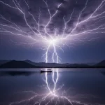
After a period of increased restlessness marked by hundreds of small earthquakes (volcanic tremors) detected by PHIVOLCS sensors, the volcano dramatically announced its awakening. At around 1:00 PM local time, a phreatic eruption—an explosion driven by steam as groundwater interacts with magma-heated rock—sent a massive, churning plume of dark ash and steam over 14 kilometers (9 miles) into the sky. The ash cloud was so vast it was easily visible from space, a dark stain spreading across satellite images. A terrifying and spectacular phenomenon known as volcanic lightning—caused by electrical charges generated by ash particles colliding violently in the plume—crackled through the dark cloud, creating a scene of apocalyptic beauty.
The ashfall was immense. Towns and cities across the Calabarzon region, including parts of Metro Manila over 60 kilometers away, were covered in a thick layer of fine gray ash. It blanketed streets, cars, and homes, turning the world monochrome. It disrupted lives, closed schools and businesses, and grounded flights at the country’s main international airport. The threat of a much larger, magmatic eruption—which would involve the direct ejection of fresh magma—led to one of the largest peacetime evacuations in Philippine history, with over 300,000 people fleeing their homes within the 14-kilometer danger zone.
The days that followed were filled with anxiety. The volcano continued to rumble, spewing lava fountains and creating new fissures on the island. The seismic activity was relentless. The 2020 event was a powerful and sobering reminder that the story of Taal is far from over. The geological forces that built this impossible island are still very much alive and active. The landscape continues to evolve, and the people who live in its shadow must forever be prepared for its next act. It underscored the critical importance of heeding scientific warnings and having robust disaster preparedness plans in place.
Visiting the Impossible: Tourism, Responsibility, and Safety
For decades, seeing Taal up close was a cornerstone of tourism in the Philippines. The classic journey was an adventure in itself, a must-do for any visitor to Luzon. It began with a colorful outrigger boat ride across the serene, seemingly endless waters of Taal Lake, the volcano island growing larger on the horizon. After landing on the volcanic island, visitors would then embark on a hike or a horseback ride up the rugged, ash-covered trails to the crater’s rim, led by local guides who knew every path.
The reward at the top was unanimously considered one of the most breathtaking and unique views on Earth: looking down from the green ridge into the steaming, acidic Crater Lake, with the tiny Vulcan Point often visible in the center, all with the vast expanse of the main Taal Lake stretching out behind you. It was a view that perfectly illustrated the geological puzzle, a real-life lesson that millions of people experienced firsthand.
However, the 2020 eruption changed everything. It highlighted the extreme and unpredictable dangers of the volcano. The Philippine Institute of Volcanology and Seismology (PHIVOLCS) maintains a strict alert level system (0-5), and the Permanent Danger Zone (PDZ) around the island is strictly enforced. While the towns around Taal Lake are open and thriving, venturing onto Volcano Island itself has been prohibited for extended periods since the eruption.
This new reality highlights a crucial lesson for all of us: we must admire such powerful natural wonders with respect and from a safe distance. Sustainable and responsible tourism means following the guidelines set by scientists and local authorities without exception. It means understanding that the volcano’s beauty is inseparable from its danger.
The view from the ridges of nearby towns like Talisay or from the famous Tagaytay Ridge is still stunning and powerful. These vantage points offer a spectacular and safe glimpse of the impossible island without venturing into the heart of the danger zone. Supporting the local economy by visiting these towns, enjoying their restaurants that overlook the lake, and learning about the volcano from museums and cultural centers represents a new, safer chapter in Taal’s tourism story—one that prioritizes life and safety above the thrill of proximity.
The Future of a Legend: Conservation, Science, and Coexistence
The future of Taal is a story still being written, and the volcano itself will continue to be the author. The task for humans is to learn to read its signs and live with its power. This challenge is met head-on by the dedicated scientists from PHIVOLCS and institutions around the world who continue to monitor it 24 hours a day, 7 days a week.
They use a vast array of technology: seismometers to listen to its faintest rumblings and deep magmatic movements; gas sensors on drones and around the lake to measure the composition and volume of its breath; GPS stations and satellite-based radar (InSAR) to detect any minute swelling or deflation of its surface; and thermal cameras and satellite technology to watch for changes in temperature and shape. This constant, vigilant watch is the first and most important line of defense for the millions of people who live in its shadow.
The challenges for the future are immense and multifaceted. It involves:
- Balancing Safety and Livelihoods: Balancing the absolute priority of population safety with the economic needs of the people whose livelihoods have long depended on the lake’s resources and tourism. Finding sustainable industries and supporting displaced communities is a critical social challenge.
- Environmental Conservation: Continuing and strengthening conservation efforts to protect unique species like the endangered tawilis from the threats of pollution, invasive species like janitor fish, and illegal fishing practices. The health of the lake ecosystem is a barometer for the health of the entire region.
- Education and Preparedness: Educating a new generation to understand, respect, and not fear the volcano’s power, ensuring a lasting culture of preparedness and resilience. This involves regular drills, clear communication plans, and integrating volcanic hazards into school curricula.
- Scientific Advancement: Continuing to study Taal to improve eruption forecasting. Every eruption provides new data that helps scientists better understand its complex plumbing system, ultimately leading to more accurate predictions and earlier warnings in the future.
The story of Taal is, in many ways, the story of our planet: dynamic, powerful, beautiful, and sometimes dangerous. It is a testament to the incredible forces that shape our world. The impossible island stands as a permanent reminder of Earth’s creative and destructive power, a geographical marvel that will continue to captivate, humble, and teach us for millennia to come. It is a symbol of both the fragility and the resilience of life, a place where the Earth’s fiery heart beats close to the surface, forever writing its epic story.
A Testament to Earth’s Power: Why Taal Captivates Us
The impossible island of Taal is more than just a quirky geographical fact or a record-breaking oddity. It is a stunning, open-air museum displaying our planet’s dynamic and creative power. It reminds us that the ground beneath our feet is not still and silent, but alive and constantly changing, a thin crust over a churning, fiery interior.
It is a place of breathtaking beauty born from unimaginable violence. It is a profound lesson in humility, showing us our small place in the face of nature’s immense, primordial forces. It is a story of resilience, both of the natural world and the human spirit that chooses to live in its shadow. And it is a thriller—a ongoing, real-time saga of fire and water, destruction and creation, that continues to unfold with every passing day, every tremor, and every quiet steam rising from its crater lake.
It is, without a doubt, one of the most fascinating and awe-inspiring places on Earth. A true Russian doll of nature, hiding its deepest secrets in the heart of the Philippines, waiting for us to listen to its ancient, rumbling story.
Hello there, simply turned into alert to your weblog through Google, and located that it is truly informative. I am gonna be careful for brussels. I’ll be grateful in the event you continue this in future. Lots of folks might be benefited out of your writing. Cheers!
I like the helpful information you provide on your articles. I’ll bookmark your weblog and check again right here regularly. I’m quite certain I’ll be told many new stuff right here! Good luck for the following!
You are a very smart individual!
It’s really a great and helpful piece of information. I’m happy that you just shared this useful information with us. Please keep us up to date like this. Thank you for sharing.
Hmm it appears like your site ate my first comment (it was extremely long) so I guess I’ll just sum it up what I submitted and say, I’m thoroughly enjoying your blog. I too am an aspiring blog blogger but I’m still new to everything. Do you have any helpful hints for rookie blog writers? I’d genuinely appreciate it.
Perfect piece of work you have done, this site is really cool with good information.
Sweet blog! I found it while surfing around on Yahoo News. Do you have any tips on how to get listed in Yahoo News? I’ve been trying for a while but I never seem to get there! Thanks
Valuable info. Lucky me I found your website by accident, and I’m shocked why this accident didn’t happened earlier! I bookmarked it.
Your house is valueble for me. Thanks!…
Hi there, You’ve performed an incredible job. I’ll definitely digg it and in my view suggest to my friends. I’m confident they will be benefited from this website.
I really appreciate this post. I have been looking all over for this! Thank goodness I found it on Bing. You’ve made my day! Thx again!
Glad to be one of many visitors on this amazing web site : D.
Thank you for the sensible critique. Me & my neighbor were just preparing to do a little research on this. We got a grab a book from our local library but I think I learned more from this post. I’m very glad to see such wonderful information being shared freely out there.
Thank you for your sharing. I am worried that I lack creative ideas. It is your article that makes me full of hope. Thank you. But, I have a question, can you help me?
Awesome blog you have here but I was wondering if you knew of any discussion boards that cover the same topics discussed here? I’d really like to be a part of community where I can get comments from other knowledgeable individuals that share the same interest. If you have any recommendations, please let me know. Bless you!